

You are here
Avalanche Advisory for 2013-03-08 07:04:04
- EXPIRED ON March 9, 2013 @ 7:04 amPublished on March 8, 2013 @ 7:04 am
- Issued by Adam Teel - Mt. Shasta Avalanche Center
Bottom Line
For today, the avalanche danger remains LOW for lower aspects and elevations and MODERATE on the mid and upper elevations.. The existing snowpack looks to be handleing the new snow well but with the accompanying winds we should expect some wind slabs, storm slabs, and crossloading. Weak interfaces have been observed in the new storm where slight density changes exist but overall the storm snow is bonding well to the old snow surface.


Avalanche Problem 1: Wind Slab
-
Character ?

-
Aspect/Elevation ?
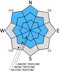
-
Likelihood ?CertainVery LikelyLikelyPossible
 Unlikely
 -
Size ?HistoricVery LargeLargeSmall

In general the winds with the new snow came from the south and the greatest deposition occured on the more northerly slopes.
Avalanche Problem 2: Storm Slab
-
Character ?

-
Aspect/Elevation ?
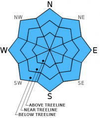
-
Likelihood ?CertainVery LikelyLikelyPossible
Unlikely
-
Size ?HistoricVery LargeLargeSmall
Where the wind hasn't had as much effect the new snow 'sluff' could accumulate and pose a threat. It is unlikely that this sluff could bury someone but sluff managment may be necessary on steeper slopes.
Recent Observations
The new snow fell on a warm old snow surface in mid elevations which should help it bond and adjust to the recently added weight. The wind with the new snow created some soft wind slabs and crossloading in the more exposed areas. There is some weakness in the upper snowpack within the new snow which which produced minimal results from Compression tests and extended column tests. The results occured on a density change which is about 45-45 cm below the snow surface. We can expect this weakness to become stronger with time and slightly warmer temps.
Weather and Current Conditions
Weather Summary
This Morning is clear, cold, and calm. Clouds are expected to move in with a 30 percent chance of snow mid-day and slight chance of thunderstorms. Some clouds will remain until midnight then clearing through Saturday bringing warmer temps. Winds will be light from the north.
WEATHER STATIONS - (last 24 hours):
In Mt. Shasta City at 0500, we have clear skies and a current temperature of 27 F.
On Mt. Shasta: In the Old Ski Bowl (7,600') on the south side of Mt. Shasta, we have a current temperature of 16 F. Snow on the ground totals 116 inches with 5 inches settlement. Temperatures have ranged from 11 F to 32F. At Grey Butte (8,000') on the south side of Mt. Shasta winds averaged 8 mph from the E with a max gust of 21 mph from the ENE. The current temperature is 18 F and temps have ranged 14 F to 30 F.
Castle/Mt. Eddy: Castle Lake - Castle Lake is hosting a current temp of 22 F. In the last 24 hours temperatures have ranged from 22 F to 41 F. Snow depth measures 57" inches with 4 inches of settlement. On Mt Eddy, we have 73 inches of snow on the ground. The current temperature reads 19 F with temps ranging from 16 F to 27 F. Winds have been averaging 2 mph from the SW and gusting to 10 mph from the East.
THIS SEASON: September and October were warm and dry with September recording exactly zero precipitation. November remained warmer than normal with precipitation almost double normal values, 9.16" vs. 5.08". A local weather COOP observed the 2nd wettest November on record. December started out wet and warm, but temperatures cooled and brought snow to very low elevations. Since our avalanche cycle near Christmas, we've had a few small storms that brought some amounts of snow to the area, but did not produced any notable avalanches. January was below normal for precipitation with a long period of high pressure and sun that kept skiing conditions somewhat meager. We've had a few storms in the past few weeks that have brought a pittance of wintery weather, but nothing to write home about! The area has been under siege by high pressure overall and giving us blue bird days for the most part. California and the Sierra Nevada have recorded the driest January and February on record. We currently have 6-10 feet of snow above 6,500 ft. Since September 1st, Mt Shasta sits at 76% of normal, 24.37" recorded; normal 31.9". For 2013, we sit at 23% of normal with 3.67" recorded and 16.02" normal. Since Tuesday we have received 1.7 inches of water which helped boost our percent of normal for the year over ten points.
| 0600 temperature: | 13 |
| Max. temperature in the last 24 hours: | 38 |
| Average wind direction during the last 24 hours: | NE |
| Average wind speed during the last 24 hours: | 8 mi/hr |
| Maximum wind gust in the last 24 hours: | 21 mi/hr |
| New snowfall in the last 24 hours: | 0 inches |
| Total snow depth: | 78-116 inches |
Two Day Mountain Weather Forecast
Produced in partnership with the Medford NWS
| For 7000 ft to 9000 ft | |||
|---|---|---|---|
|
Friday (4 a.m. to 10 p.m.) |
Friday Night (10 p.m. to 4 a.m.) |
Saturday (4 a.m. to 10 p.m.) |
|
| Weather | Sunny in the morning then increasing clouds by mid-day. Chance of precip. with a slight chance of thunderstorms. | Partly Cloudy and clearing after midnight | Sunny |
| Temperature (°F) | 35 | 19 | 41 |
| Wind (mi/hr) | N 5-10 | NE 7-13 with gusts higher | N 5-10 |
| Precipitation SWE / Snowfall (in) | / Less than one | / Less than one | / 0 |
| For 9000 ft to 11000 ft | |||
| Friday | Friday Night | Saturday | |
| Weather | Sunny in the morning then increasing clouds by mid-day. Chance of precip. with a slight chance of thunderstorms. | Partly cloudy then clearing after midnight | Sunny |
| Temperature (°F) | 20 | 7 | 30 |
| Wind (mi/hr) | NE 5-10 | NE Less than one | NE 10-20 mph with gusts higher |
| Precipitation SWE / Snowfall (in) | / Less than one | / Less than one | / 0 |

