

You are here
Avalanche Advisory for 2014-04-05 06:32:57
- EXPIRED ON April 6, 2014 @ 6:32 amPublished on April 5, 2014 @ 6:32 am
- Issued by Nick Meyers - Shasta-Trinity National Forest
Bottom Line
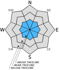
The avalanche danger for all aspects and elevations is LOW. Isolated pockets of MODERATE wind slab and loose snow avalanche danger exists, especially in complex or extreme terrain on N - NE - E - SE aspects.
Normal caution is advised.
Carry a beacon, shovel and probe and know how to use them!


Avalanche Problem 1: Wind Slab
-
Character ?

-
Aspect/Elevation ?
-
Likelihood ?CertainVery LikelyLikelyPossible
 Unlikely
 -
Size ?HistoricVery LargeLargeSmall

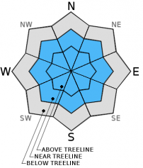
Lingering wind slabs have gained strength and have become difficult to trigger, though not impossible. Instability is most likely to be encountered near and above treeline, especially in complex or extreme terrain on N - NE - E - SE aspects, but not limited to. Wind slabs could be small to large is size.
Northwest winds will pick up today and tomorrow. Wind loading will occur on E - SE - S slopes in the next 24-48 hours and wind slab avalanches will be most sensitive to trigger during that time.
Avalanche Problem 2: Storm Slab
-
Character ?

-
Aspect/Elevation ?
-
Likelihood ?CertainVery LikelyLikelyPossible
Unlikely
-
Size ?HistoricVery LargeLargeSmall
Loose snow avalanches on slopes steeper than 38 degrees and/or extreme terrain will be possible today . These avalanches will likely not be large enough to bury a person, but could sweep one off their feet and into undesireable terrain.
Avalanche Problem 3: Cornice
-
Character ?

-
Aspect/Elevation ?

-
Likelihood ?CertainVery LikelyLikelyPossible
Unlikely
-
Size ?HistoricVery LargeLargeSmall
Small to medium size cornices have formed near ridgetops and bowls over the past weeks. Stay on terra firma when scoping your line or climbing ridge routes!
Recent Observations
Visibility was difficult again above treeline yesterday and thus kept observations on and around Gray Butte. A full tour of all aspects found 10-15cm of new, light density snow on top of a widespread, 1-3cm crust layer that formed over Wednesday and Thursday. Temperatures stayed cool enough to preserve the new snow even late in the day. Formal snowpit tests indicated a weak layer just below the crust on near crust facets with moderate force, but failure and propagation on a slope scale wasn't happening. My inclination is that the poorly developed facets are mending and not developing further.
On an east facing, 40 degree slope, one small wind slab was easily triggered. The slide had a 6 inch crown, was about 15 feet wide and ran about 70 feet down the slope. While not large enough to bury a person, larger slides such as this could be waiting for a trigger. The most common instability observed yesterday was new snow sluffing on top of the 1-3cm crust on steep slopes. Numerous loose, dry snow avalanches were easily triggered from ski cutting slopes near starting zones.
For today, I would expect the same types of instabilities as said above for all aspects/elevation areas until temps warm and the sun comes out. As for the upper mountain, I have not been able to observe snow conditions. It's uncharted territory since this past storm cycle. I would use caution and expect isolated areas hosting small to medium wind slabs, especially after this weekend northwest winds picking up.
----------------------------------------------------
From 4/4/14
The storm cycles of the past two weeks have added precious inches of snow to our low snowpack, extending our season of good climbing and skiing conditions by hopefully a few weeks. We saw a short lived spike in the avalanche danger on Monday of this past week. Numerous, small storm slab avalanches were easily triggered on many aspects steeper than 35 degrees near and above treeline on Gray Butte and one reported slide on the north aspect of Green Butte. Tuesday, our snowpack seemed to adjust well to the new snow (6-8 inches over 48 hours) and no further instability was observed over the week. Wednesday and Thursday the sun came out during the day cooked the new snow to a crisp. Which brings us to our current snow status: generally crispy (read: breakable crust) at lower and mid elevation slopes with pockets of old powder in shaded, cold and protected areas in the trees. Everything above treeline is generally wind blown in exposed areas and packed powder/powder in more protected areas. Southerly winds in the recent days has transported snow onto N - NE slopes and small to medium size, isolated wind slabs could be encountered above treeline on said aspects, albeit difficult to trigger. Overall, the snowpack sits in a transitional phase, working towards melt/freeze, but not their yet. With the weather clearing and temps warming in the coming days, we should see Shasta's famed spring skiing return, hopefully by next week.
For climbers, conditions have been excellent on all routes. With the recent new snow however, be sure to thoroughly read this avalanche advisory. Over snow travel with the new snow will be difficult (i.e. post-holing) without snowshoes/skis/splitboard at this time. The season for climbing Mt Shasta is going to be shifted forward this year. On a normal year with ample snow on the ground, good climing conditions usually start in April and can go all the way into July sometimes. This year is not the case...the best conditions to climb Shasta this year will be NOW through April and potentially May. The extent of good climbing conditions will hinge on our Spring weather. More snow could potentially extend the season and warm days with shining sun will shorten it. While the mountain looks like it's got a thick blanket of snow on it, in reality there is only about 2-5 feet of snow on the ground, depending on aspect and elevation. Good climbing conditions, in general, means snow on the mountain. As the snow melts, rockfall increases and a climb of Shasta becomes more dangerous. All in all, sooner than later will be best for climbing Shasta. Check the climbing advisory on our webpage also!
PLEASE NOTE: Snow conditions on most routes are smooth and firm, especially in the AM hours. Conditions as such have lead to accidents due to slip/falls and failure to self arrest. A slip and fall on smooth, firm and sometimes icy snow can result in a slide for life on the steeper slopes of Mt Shasta. Self arrest skills with an ice axe and proper crampon use are essential for a safe climb. Do not under estimate the importance of proper knowledge and skills with your ice axe/crampons/self arrest techniques. Further, an avalanche beacon, shovel and probe are recommended for any climbers attempting Shasta currently. Lastly, with snow on mountain, the rockfall danger has been low. However, rime ice can plaster exposed rocks on Shasta this time of year. As the days warm, the rime ice will flake off and fall onto climbers below, especially on the Avalanche Gulch route. Ice is like a rock and a HELMET should always be worn.
--------------------------------------------------------------------------------------------------------------------------------------------------------------
While Northgate, Brewer Ck and Clear Ck trailheads are officially closed, the bathrooms are still open with packout bags inside, and one can still access the Mt Shasta Wilderness. However, your summit pass and wilderness permits must be purchased at McCloud or Mt Shasta Ranger Stations. NO DOGS are allowed in the Mt Shasta Wilderness OR Sierra Club Property. Thanks!
---------------------------------------------------------------------------------------------------------------------------------------------------------------
Terrain: Remember most of the terrain that we like to play on is greater than 30 degrees. Avalanches are possible on anything steeper than 30 degrees. Avoid cornices, rock bands, terrain traps and runout zones of avalanche paths.
Weather: Most of our areas avalanche danger will occur 24-48 hours after a storm. We still can see persistent weak layers from time to time and we always will be sure to let you know about that! Heed the basic signs: Wind (significant snow transport and depositions), Temperature (rain/snow/rain/snow, which in turn weakens the snowpack), and Precipitation (Snow or rain add weight and stress to the current snowpack).
Snowpack: If snow accumulates, give the snowpack a chance to adjust to the new snow load before you play on or near steep slopes (greater than 30 degrees). Most direct action avalanches occur within 24-48 hours of recent snowfall. Watch for obvious signs of snowpack instability such as recent natural avalanche activity, collapsing of the snowpack (often associated with a “whumphing” sound), and shooting cracks. If you see these signs of instability, limit your recreation to lower angle slopes.
Human Factor: Don’t forget to carry and know how to use avalanche rescue gear. You should NOT be skiing or climbing potential avalanche slopes without having beacons, shovels, and probes. Only one person in a group should be exposed to potential avalanche danger at a time. Remember, climbing, skiing, and riding down the edge of slopes is safer than being in the center. Just because another person is on a slope doesn’t mean that it is safe. Be an individual! Make your own decisions. Heed the signs of instability: rapid warming, “whumphing” noises, shooting cracks, snowing an inch an hour or more, rain, roller balls, wind loading, recent avalanche activity.
Weather and Current Conditions
Weather Summary
n Mt Shasta City this morning at 0500, we have clear skies with a current temperature of 30F.
On Mt Shasta (South Side) in the last 24 hours...
Old Ski Bowl - 7,600 feet. The Old Ski Bowl weather station has a 1-2 inches of new snow in the last 24 hours. The current temperature is 21F with a low of 20F and a high of 32F. Total snow depth is 77 inches.
Gray Butte - 8,000 feet - The current temperature is 21F. Temps have ranged from a low of 19F to a high 29F. Winds have been mostly calm, averaging 4 mph from the west/northwest with max gusts topping out at 28 mph from the NW also.
Castle Lake and Mt Eddy (West side of I-5)...
Castle Lake - 5,600 feet, the current temperature is 28F with a low of 26F and a high of 49F. Castle Lake has received 1-2 inches of new snow and hosts a current snowpack of 9 inches at the weather station.
Mt Eddy - 6,500 feet, the current temperature is 27F with a low of 22F and a high of 35F. Mt Eddy has received 1-2 inches of new snow and the current snow depth total is 29 inches. Winds have averaged 1 mph, with gusts to 7 mph, out of the southeast.
THIS SEASON: Since September 1st , we have received 13.77 inches of water, normal is 36.59 inches, putting us at 37% of normal. For the year of 2014, Mt Shasta has received 10.95 inches of water with normal being 20.71 inches which puts us at 52% of normal. And lastly, for April we sit at 117% of normal, receiving .54 inches of water, normal is .46 inches. Mt Shasta finished off March at 73% of normal, accumulating 4.37 inches of water with normal being 5.96 inches.
WEATHER SYNOPSIS:
Our gradual drying and warming trend is still happening, albeit slowly! We will see some potential scattered showers and clouds today, otherwise general clearing should continue through the weekend. Northwest flow is setting up which will bring Mt Shasta's familiar northwest winds onto the mountain. We will see the wind pick up today and will blow the hardest on Sunday, and then calm back down on Monday. While not hurricane force, I'd expect 30-40 mph with gusts higher on the upper mountain on Sunday. At this point, April has been a wet one with above normal precipitation amounts, however we are setting up for clear weather next week. But...climbers, skiers and outfitter guides are all hoping for more late winter storms to help prolong the spring season on Shasta...keep doin' yer dance!
Always check the weather before you attempt to climb Mt Shasta. Further, monitor the weather as you climb. Becoming caught on the mountain in any type of weather can compromise life and limb.
| 0600 temperature: | 22 |
| Max. temperature in the last 24 hours: | 29 |
| Average wind direction during the last 24 hours: | Northwest |
| Average wind speed during the last 24 hours: | 4 mi/hr |
| Maximum wind gust in the last 24 hours: | 28 mi/hr |
| New snowfall in the last 24 hours: | 1-2 inches |
| Total snow depth: | 77 inches |
Two Day Mountain Weather Forecast
Produced in partnership with the Medford NWS
| For 7000 ft to 9000 ft | |||
|---|---|---|---|
|
Saturday (4 a.m. to 10 p.m.) |
Saturday Night (10 p.m. to 4 a.m.) |
Sunday (4 a.m. to 10 p.m.) |
|
| Weather | Chance of snow, partly sunny | Chance of showers, mostly cloudy | Mostly sunny, slight chance of rain/snow showers in AM |
| Temperature (°F) | 46 | 34 | 56 |
| Wind (mi/hr) | Northwest 5-15 mph | Northwest 15-20 mph | Northwest 10-15 mph |
| Precipitation SWE / Snowfall (in) | / 0-.5 | / 0-.5 | / 0 |
| For 9000 ft to 11000 ft | |||
| Saturday | Saturday Night | Sunday | |
| Weather | Chance of snow showers, partly sunny | Chance of snow showers, mostly cloudy | Mostly sunny, slight chance of snow showers in AM |
| Temperature (°F) | 28 | 26 | 40 |
| Wind (mi/hr) | Northwest 25-35 mph | Northwest 0-.5 | Northwest/North 40-50 mph, decreasing in afternoon |
| Precipitation SWE / Snowfall (in) | / 0-.5 | / 0-.5 | / 0 |

