

You are here
Avalanche Advisory for 2015-03-28 07:00:33
- EXPIRED ON March 29, 2015 @ 7:00 amPublished on March 28, 2015 @ 7:00 am
- Issued by Jon Dove - Shasta-Trinity National Forest
Bottom Line
The avalanche danger is currently LOW for all elevations and aspects. Loose wet snow instabilities, roller balls, and pin wheels are possible on S-SE-E aspects, especially in the afternoon. Slides large enough to bury a person are unlikely, however, they can knock one off their feet and push them into undesirable terrain. Normal caution is advised.
Carry a beacon shovel and probe. Wear a helmet. Know how to use your ice axe and crampons.


Avalanche Problem 1: Loose Wet
-
Character ?

-
Aspect/Elevation ?
-
Likelihood ?CertainVery LikelyLikelyPossible
 Unlikely
 -
Size ?HistoricVery LargeLargeSmall

Loose wet snow instabilities, roller balls, and pin wheels are possible on S-SE-E aspects, especially during the warmest parts of the day. Slides large enough to bury a person are unlikely, however, they can knock one off their feet and push them into undesirable terrain. Normal caution is advised.
Recent Observations
Our good friend "corn snow" is back in action! The mountain received a fresh coating of new snow at the beginning of the week that made for a day or two of powder skiing/riding. This was followed by warm temperatures and clear skies that paved the way for a couple of days of melt/freeze magic. This has resulted, once again, in producing prime corn snow conditions on Mt. Shasta. If we can't have powder snow, corn is the next best thing. The weather forecast for the next couple of days looks to promote the melt/freeze process and make for a great weekend to get up on Mt. Shasta and enjoy Spring corn snow! Sunny skies and warm temperatures will persist through Monday. Winds will be light to moderate (depending on elevation) staying more northerly in direction.
Observations made yesterday confirmed that the transition from new snow to corn snow was just about complete. A snowmobile assisted climb and ski of the chute below Shastarama on Sargents Ridge was the perfect objective to test snow conditions from below tree line to the upper elevations near 11,000 feet. Snow surfaces were firm in the morning, even below tree line, despite overnight temperatures staying above freezing at elevations below 10,500 feet. From where snowmobiles were parked at about 9,000 feet crampons were necessary to climb directly up the chute below the Shastarama rock outcropping. As we climbed snow was boot supportable with a few inches of penetration of the toe of the boot possible. At times the snow surface was firm enough that only the spikes of the crampon could penetrate requiring French step climbing technique. We started our descent at a few minutes before noon and had perfect corn top to bottom. That being said, only S-SE-E facing aspects were softening. Any aspects that were NW-N-NE facing stayed firm. There was no sign of any loose wet slides in Old Ski Bowl. There was evidence of roller balls, but most of the scattered debris was the result of rime ice that had peeled off of rocks along the ridge top.
Photos:
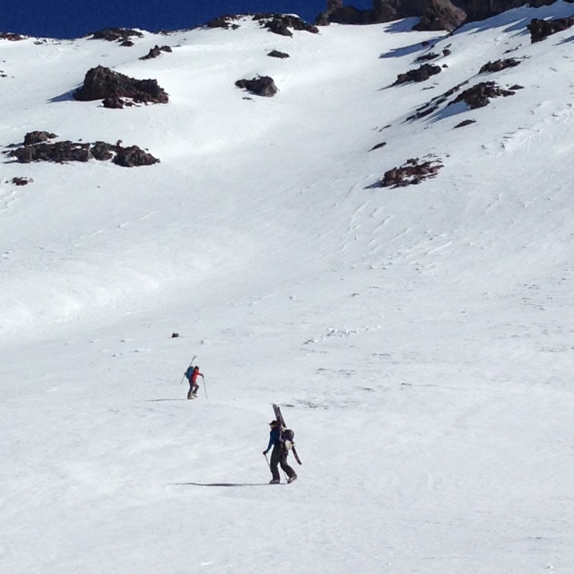
Top Left- Forrest and Alyssa below Shastarama chute on ascent 3/27/2015 - Photo: Jon Dove
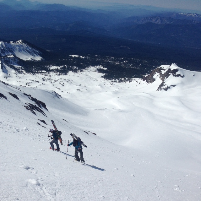
Top Right- Shay and Alyssa climbing up into the Shastarama chute proper 3/27/2015 - Photo: Jon Dove
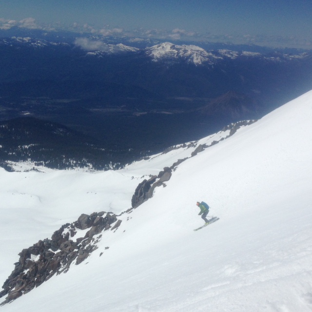
Bottom- Forrest dropping in and slaying the corn, top of Shastarama chute 3/27/2015 - Photo: Jon Dove
Continue to always use safe travel methods: carry situational awareness on your skin up the mountain, choose safe routes and watch for what others are doing, ski one at a time, stop in safe zones!
For folks that plan on climbing Mt. Shasta: Route conditions on Casaval Ridge, Sargents Ridge, and Avalanche Gulch are currently good. Snow conditions have made the melt/freeze transition into supportable firm snow at most elevations and aspects. Snow on more northerly facing aspects may host snow that has not fully transitioned yet, and may be a little punchy. This means that boot penetration of a few inches is possible. Firm snow on W-SW-S-SE-E aspects will soften some during the day making for corn snow conditions. Climbers should be advised that the presence of firm, smooth snow means the possibility for a long fall is present. "Slide for life" conditions exist if self-arrest is not achieved immediately! Ice fall from rime ice that has built up on the Red Banks and other rock outcroppings will be happening even in the early morning hours. A helmet, crampons, and a mountain axe are necessary equipment and should be used.
Castle Lake and Mt Eddy zones are still hosting a shallow snowpack. All areas below about 6,000 feet in the forecast area are hosting patchy snow with dirt showing around trees and in sunny spots. For Castle Lake, skiing is out of the question at this point due to lack of snow.
Report your observations to the MSAC! A photo, a few words... send them in! (nimeyers@fs.fed.us or 530-926-9614)
Sand Flat Winter Trails: OPEN, however snow depths are meager and the Lower Sand Flat road is exposed dirt. We recommend heading up to Bunny Flat and touring up the road or anywhere higher in elevation!
Pilgrim Creek Snowmobile Park: CLOSED due to lack of snow
-------------------------------------------------------------------------------------------------------------------------------
Terrain: Remember most of the terrain that we like to play on is greater than 30 degrees. Avalanches are possible on anything steeper than 30 degrees. Avoid cornices, rock bands, terrain traps and runout zones of avalanche paths.
Weather: Most of our areas avalanche danger will occur 24-48 hours after a storm. We still can see persistent weak layers from time to time and we always will be sure to let you know about that! Heed the basic signs: Wind (significant snow transport and depositions), Temperature (rain/snow/rain/snow, which in turn weakens the snowpack), and Precipitation (Snow or rain add weight and stress to the current snowpack).
Snowpack: If snow accumulates, give the snowpack a chance to adjust to the new snow load before you play on or near steep slopes (greater than 30 degrees). Most direct action avalanches occur within 24-48 hours of recent snowfall. Watch for obvious signs of snowpack instability such as recent natural avalanche activity, collapsing of the snowpack (often associated with a “whumphing” sound), and shooting cracks. If you see these signs of instability, limit your recreation to lower angle slopes.
Human Factor: Don’t forget to carry and know how to use avalanche rescue gear. You should NOT be skiing or climbing potential avalanche slopes without having beacons, shovels, and probes. Only one person in a group should be exposed to potential avalanche danger at a time. Remember, climbing, skiing, and riding down the edge of slopes is safer than being in the center. Just because another person is on a slope doesn't’t mean that it is safe. Be an individual! Make your own decisions. Heed the signs of instability: rapid warming, “whumphing” noises, shooting cracks, snowing an inch an hour or more, rain, roller balls, wind loading, recent avalanche activity.
The Five Red Flags of Avalanche Danger any time of year include: 1) Recent/current avalanche activity 2) Whumpfing sounds or shooting cracks 3) Recent/current heavy snowfall 4) Strong winds transporting snow 5) Rapid warming or rain on snow.
Weather and Current Conditions
Weather Summary
In Mt Shasta City this morning at 0500, we have clear skies and a current temperature of 42 F degrees. Winds picked up at 2:00 am, north 10 to 15 mph with gusts to 20+ mph
WEATHER STATION INFORMATION (0500hrs):
On Mt Shasta (South Side) in the last 24 hours...
Old Ski Bowl - 7,600 feet, the current temperature is 43 F. Snow on the ground totals 82 inches with 1 inch settlement. Temperatures have ranged from 39 F to 54 F.
Gray Butte - 8,000 feet, the current temperature is 42 F. Temps have ranged from 38 F to 50 F. Winds have been variable blowing southerly shifting to more northerly around 2200 and increasing in speed significantly. Winds reached 40-54 mph with gusts to 85 mph, NNW.
Castle Lake and Mt Eddy (West side of Interstate-5)...
Castle Lake - 5,600 feet, the current temperature is 30 F. Temps have ranged from 30 F to 62 F. The Castle Lake area has very little snow left on the ground.
Mt Eddy - 6,500 feet, the current temperature is 31 F. Temps have ranged from 31 F to 54 F in the last 24 hours. Current snow depth is 18 inches with 1 inch settlement. Winds have been averaging 3 mph, with gusts to 9 mph, ENE.
WEATHER SYNOPSIS: A surface high pressure will gain strength over the area bringing mostly sunny skies with some scattered clouds in the afternoon. Temperatures will be 5-10 degrees cooler today than yesterday, yet will still be above normal for this time of year. Temperatures will then increase by about 5 degrees for Sunday and Monday with warm sunny skies. Winds are forecast to be light at 5-15 mph out of the north for near and below tree line. At the mid and upper elevations (above 9,500 feet) winds will be moderate at 15-30 mph with higher gusts, westerly in direction.
THIS SEASON PRECIPITATION: Since October 1st (the wet season) , we have received 31.43 inches of water, normal is 34.93 inches, putting us at 89% of normal. For the month of March, we sit at 1.27 inches of water, normal is 5.43, putting us at 23% of normal. For the year of 2015, we've received 11.91 inches water, normal is 19.72, equalling 60% of normal.
Snow Survey Results for March 2015 for the Sacramento, Shasta and Trinity Watersheds: 49% of normal with at average depth of 37 inches. Historic average for snow is 76.8 inches. Last year at this time we were 36% of normal. Similar years to this year are 1936, 1977, 1988, 1994.
Always check the weather before you attempt to climb Mt Shasta. Further, monitor the weather as you climb. Becoming caught on the mountain in any type of weather can compromise life and limb. Be prepared.
| 0600 temperature: | 43 |
| Max. temperature in the last 24 hours: | 54 |
| Average wind direction during the last 24 hours: | Variable |
| Average wind speed during the last 24 hours: | 8 mph until 2100 then increasing to 40 to 50 mph mi/hr |
| Maximum wind gust in the last 24 hours: | 85 mph mi/hr |
| New snowfall in the last 24 hours: | 0 inches |
| Total snow depth: | 82 inches |
Two Day Mountain Weather Forecast
Produced in partnership with the Medford NWS
| For 7000 ft to 9000 ft | |||
|---|---|---|---|
|
Saturday (4 a.m. to 10 p.m.) |
Saturday Night (10 p.m. to 4 a.m.) |
Sunday (4 a.m. to 10 p.m.) |
|
| Weather | Sunny | Mostly Clear | Mostly Sunny |
| Temperature (°F) | 55 | 35 | 61 |
| Wind (mi/hr) | North 10-15 mph | North 5-10 mph | North Around 5 mph |
| Precipitation SWE / Snowfall (in) | / 0 | / 0 | / 0 |
| For 9000 ft to 11000 ft | |||
| Saturday | Saturday Night | Sunday | |
| Weather | Sunny | Mostly Clear | Partly Cloudy |
| Temperature (°F) | 50 then lowering to 35 in the afternoon | 34 then rising | 50 |
| Wind (mi/hr) | Northwest 20-30 mph with gusts to around 45 mph | West-Southwest 0 | West-Northwest 15-20 mph with gusts to around 30 |
| Precipitation SWE / Snowfall (in) | / 0 | / 0 | / 0 |

