

You are here
Avalanche Advisory for 2016-03-12 07:06:24
- EXPIRED ON March 13, 2016 @ 8:06 amPublished on March 12, 2016 @ 7:06 am
- Issued by Nick Meyers - Shasta-Trinity National Forest
Bottom Line
A winter storm warning is in effect - 10am today to 5am Monday. Moderate to high south wind and rapid accumulation of snow expected. Up to 2.75" snow/water equivalent by 3/14.
Today, the avalanche danger will begin at MODERATE for all elevations and aspects, but will rise to CONSIDERABLE with pockets of HIGH danger late in the day. Heavy precipitation will quickly build wind and storm slabs. Use extreme caution during these series of storms this weekend.


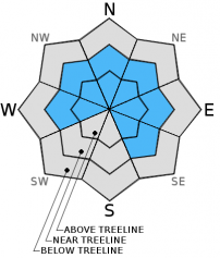
Avalanche Problem 1: Wind Slab
-
Character ?

-
Aspect/Elevation ?
-
Likelihood ?CertainVery LikelyLikelyPossible
 Unlikely
 -
Size ?HistoricVery LargeLargeSmall

Much of the new snow over this past week has simply been too heavy for efficient wind transport. That will change with this weekend's storm as temperatures have cooled and the new snow is much lighter and available for transport. Existing wind slabs are certainly possible, especially at higher elevations, however the most concern lies with NEW wind slab formation. Slopes W-NW-N-NE-E-SE facing, near and above treeline, will wind load due to strong southerly winds. Small to medium size slabs are certain. Rapid precipitation rates with wind will cause the danger trend to rise later today and tomorrow. It won't be until the sun comes back out and we've had a few days of good weather that the danger will lower.
Use caution, conduct stability tests and don't trust those wind slabs. Lack of above treeline observations leave uncertainty concerning wind slab stability. Unstable wind slabs are likely immediately during or just after new snow and wind events. Cross loading of slopes and mid-slope wind loaded areas are more common during extreme wind events. Wind can deposit snow onto leeward aspects MUCH FASTER than snow falling from the sky.
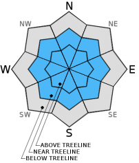
Avalanche Problem 2: Storm Slab
-
Character ?

-
Aspect/Elevation ?
-
Likelihood ?CertainVery LikelyLikelyPossible
Unlikely
-
Size ?HistoricVery LargeLargeSmall
The chances of triggering a storm slab are much better today with the lighter density snow that is falling. New storm slabs on top of our snowpack will form from rapid precipitation rates. Near treeline in areas that are protected from the wind will be the best places to find any storm slab activity. Early this morning, concern is low, however later today and tomorrow, the danger trend will rise.
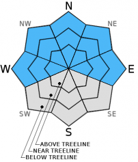
Avalanche Problem 3: Cornice
-
Character ?

-
Aspect/Elevation ?
-
Likelihood ?CertainVery LikelyLikelyPossible
Unlikely
-
Size ?HistoricVery LargeLargeSmall
Cornice formation has been good recently with the sticky, wet snow. Continued cornice development today and tomorrow is certain. The bottom line: stay back, well away from the edge. Identify terra firma like trees or rocks protruding from the snow and keep to those areas. Cornices, small to large, can break and also trigger a slide below. If you're with it, game over.
Recent Observations
A March 11th (yesterday) sojourn up to about 9,000 feet on the south side of Mt Shasta gave way to much better snow conditions compared to the wet cascade chunder of the day prior. Temperatures were already a few degrees cooler yesterday morning and dropped further as the day progressed and the cold front pushed into the area. Snow levels started near 6,000 feet but dropped to about 5,000 feet later in the day. Wet snow was still the standard below 7,500 feet, however conditions changed for the better above that elevation. About 6-9 inches of dryer snow was found in most areas due to light wind speeds. Another 6 inches fell last night. Overall, since last Sunday, March 6th, 44 inches of snow has fallen for a storm total thus far of almost 4 feet! And now...another several feet of snow forecast for today through Monday with, FINALLY, some cooler temps to keep things real in our winter playground. Total height of snow at treeline for the 2015/16 winter is 154 inches.
By golly with all the rapid accumulation of snow we've had at times over the week, you would think we would have seen a few more slides other than the Casaval and East side events early on. Visibility has been a big part of the issue...near and above treeline where we'd expect much of the action...one hasn't been able to see much farther than a 1/4 mile at best, thus limiting safe travel. That doesn't mean we haven't been out digging like a dog, looking for instabilities.
With discussion from cohorts, it's thought that due to the warm nature of the storms over the week with short periods of sun and/or rise in temperatures, the snowpack is simply adjusting quickly and settling out very well, almost as it falls. The heavy, wet and sticky snow is bonding to old surfaces, crusts and to itself. Snow pit stability tests and all other observations have not revealed any glaring, unstable results. The warm nature of the snow storms and sun in between has kept it all glued together, essentially. This does not mean that it's all good to go, however. We can double what new snow we've already received over the week... in the next three days. We're not out of the danger zone yet.
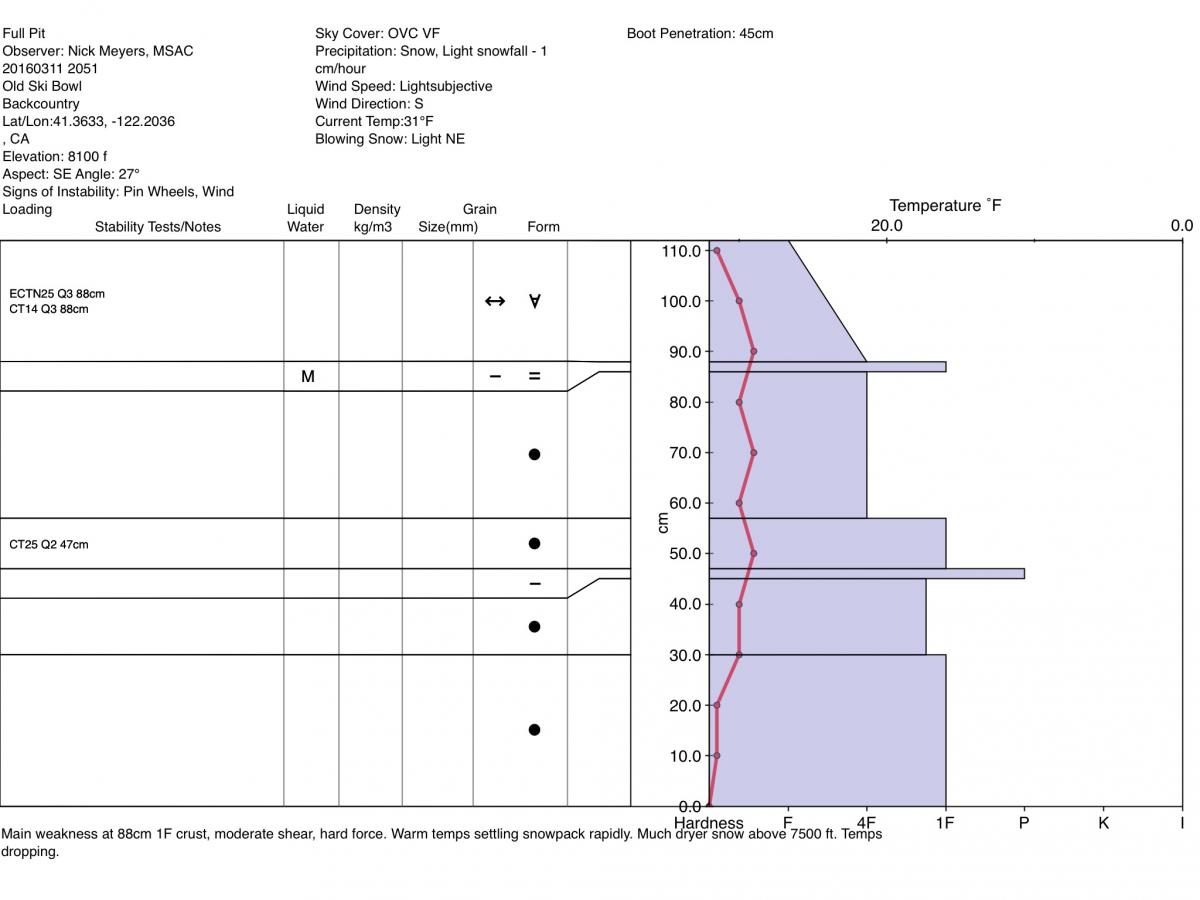
Getting into the dirt of it- Yesterday I dug a pit at 8,100 feet on a southeast aspect/25 degree slope in the Old Ski Bowl area, near treeline. Storm total, new snow since 3/6 was 112cm. The sky was completely obscured, it was lightly snowing with light, gusty winds out of the south/southwest. Air temp: 31 F. We have a right side up snowpack hosting two main crusts with one finger to four finger density hardness snow in between the two crusts. The lower crust, the March 7th crust I've mentioned in past advisories this week, is widespread and quite strong. I don't see any weak layers propagating below this crust. The second crust, occurring on March 10th, is much softer (one finger), sits in the upper portion of the snowpack, and is/was moist snow, partially frozen. Stability tests resulted in not much... multiple compression tests 15-20 @ 88 and 47cm up from the old snow. (The OLD snow is very easily discernable by the way. Just dig, you'll find it.) Extended column tests gave way to ECTN/X 20-30 at 88cm up from old snow. The leading weak layer with all tests was just above the newest March 10th crust layer. Shear and fracture quality were moderate to poor. I did note a nice layer of graupel just above the March 7th crust...something to note as graupel can be a decent weak layer.
Today, all avalanche prone slopes with ample new snow, wind loaded leeward ridge lines, cornices...it should all be suspect. Weaknesses in the snowpack could lie within the new snow from today and tomorrow, OR could step down into the "old" snow layers from the past week.
The snow will pile up quickly, perhaps several inches an hour. The snow pack does not like rapid change! Existing wind slabs will continue to build in size with steady precipitation expected today. Southerly winds will load NW-N-NE-E-SE slopes. Subtle changes in temperature and snow levels will create different density snow layering. It's often that these density changes act as the weak layer. Your 'A" game is going to be necessary and it might just be a good idea to stay off avalanche terrain entirely. Periods/pockets of HIGH avalanche danger are possible immediately during or just after these storms.
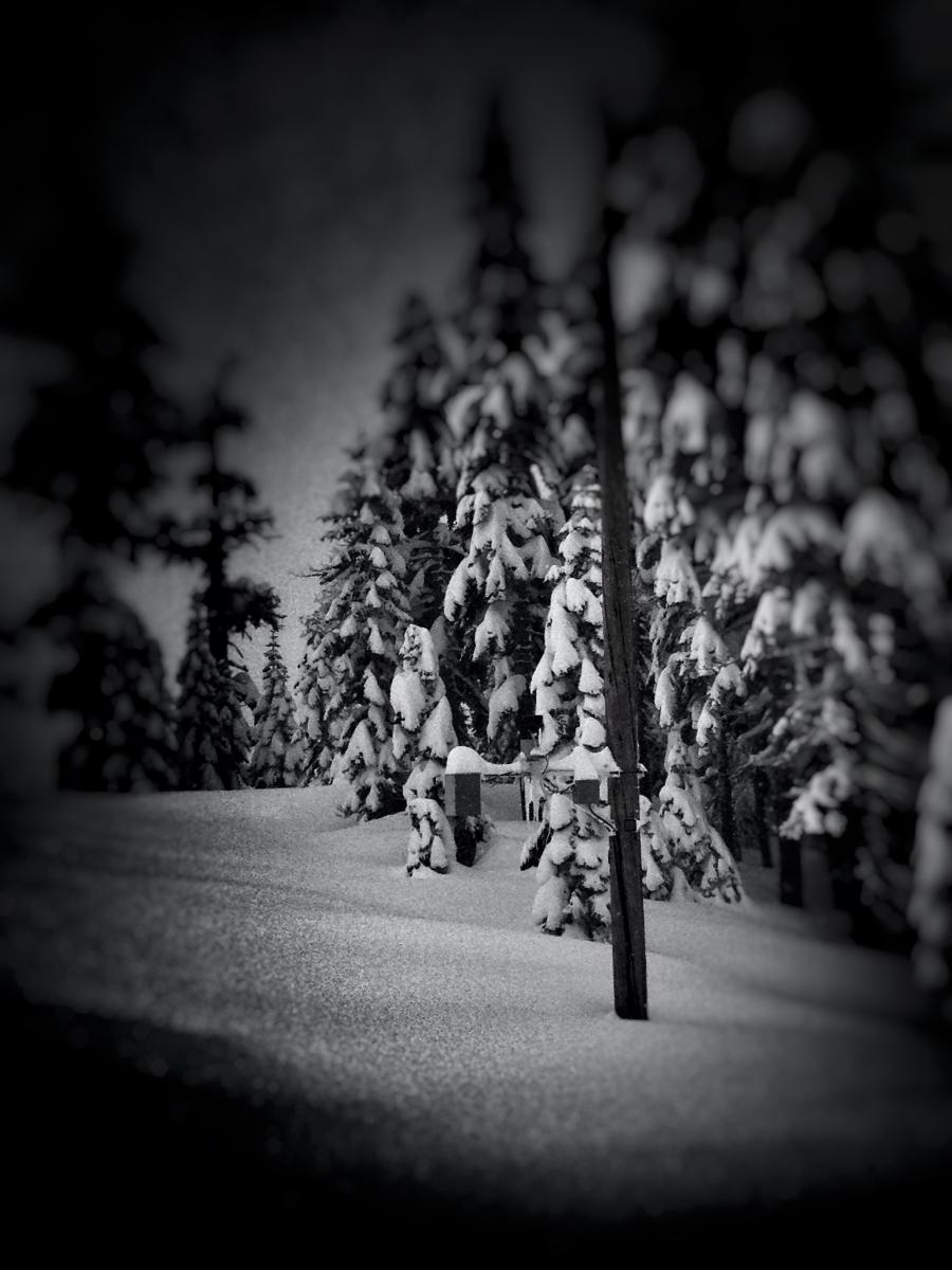
LEFT: Can you see the snow depth sensor? Old Ski Bowl weather station. The snow depth sensor is about 20 feet off the ground! Not buried yet, but getting close! If you're snowmobiling or skiing near it, please do not ride below the sensor. Thanks!
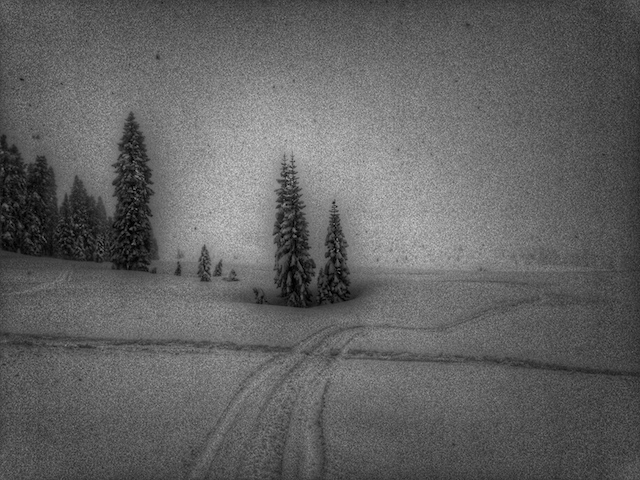
RIGHT: This is how the visibility has been for much of the week near and above treeline on Mt Shasta. This shot taken from the lower ramparts of the Old Ski Bowl, near the weather station.
-----------------------------------------------------------------------------------------------------------------------------------------------------------
LOCAL AREA ROAD, NORDIC, AND SNOWMOBILE PARK STATUS:
The Sand Flat cross country ski trails are in good shape and ready for your cross country skis and snow shoes. These are backcountry routes marked with blue diamonds on trees. Trails are not groomed. Snow shoers, please blaze a parallel trail to cross country skiers staying out of the skin track. These trails can be accessed via the Everett Memorial Highway. Thank you, and enjoy!
The Mt. Shasta Nordic Center is open! These beautiful, groomed trails can be accessed via the Ski Park Highway. http://www.mtshastanordic.org
The Pilgrim Creek & Deer Mountain Snowmobile Parks are open! Trails have not been groomed in the past week and a half due to warm temperatures. Head to our "Education" tab on our website and find the snowmobile section for trail information, grooming status, and other sledder resources.
The Castle Lake Road is CLOSED at the gate. The culvert blew out and we do not know when it will be repaired. The Everett Memorial Highway is plowed to Bunny Flat.
The Five Red Flags of Avalanche Danger any time of year include: 1) Recent/current avalanche activity 2) Whumphing sounds or shooting cracks 3) Recent/current heavy snowfall 4) Strong winds transporting snow 5) Rapid warming or rain on snow.
Weather and Current Conditions
Weather Summary
Good Morning! In Mt Shasta City at 0500, we have a current temperature of 37 F, five degrees cooler than yesterday at this time. Skies are obscured with light rain falling at times, breezy.
On Mt Shasta (South Side) in the last 24 hours...
Old Ski Bowl - 7,600 feet, the current temperature is 23 degrees F. Snow on the ground totals 154 inches with 7 inches new snow and little settlement. Temperatures have ranged from 23 F to 32 F.
Gray Butte - 8,000 feet, the current temperature is 23 degrees F. Temperatures have ranged from 22 F to 28 F. Winds have averaged 10 mph, southwesterly - with gusts to 28 mph, south/southeast.
Mt Eddy Range (West side of Interstate-5)...
Castle Lake - 5,600 feet, the current temperature is 28 degrees. Temperatures have ranged from 28 F to 33 F. Snow on the ground totals 72 inches with six inches new snow and little settlement.
Mt Eddy - 6,500 feet, the current temperature is 25 degrees F. Temperatures have ranged from 25 F to 32 F. Snow on the ground measures 92 inches with 7 inches new snow and little settlement. Winds have averaged 2 mph with a max gust of 13 mph, south/southwest.
Always check the weather before you attempt to climb Mt Shasta. Further, monitor the weather as you climb. Becoming caught on the mountain in any type of weather can compromise life and limb. Be prepared.
---------------------------------------------------
WEATHER DISCUSSION:
If these storms over the week were not enough for you, then Mother Nature has an answer. A major winter storm event is on tap and the worst (or best) of it has even yet to come. A winter storm warning has been issued by the National Weather Service beginning at 10am this morning through 5am Monday. Snow, snow and more snow is in store for the area this weekend. Models suggest approximately 2.75 inches of water by Monday morning. Snow levels will drop to around 4,000 feet today. Above 7,000 feet, snow accumulation amounts could be 4-6 feet by the time the storms end. Winds will blow southerly in nature, moderate and steady at 20-30 mph for most of the weekend at lower to mid mountain levels. Exposed areas and the upper mountain will see gale force southerly winds of 50+ mph with gusts higher. Temperatures have fallen several degrees this morning and should remain that way. A slight warm up will occur Sunday, but not by much and cooling back down by Sunday night / Monday morning. Mt Shasta City should get a little bit of snow also. Any break in the action this weekend will be short lived. It won't be until Monday afternoon that we begin to see much clearing. Miracle March at its finest! Stay safe.
THIS SEASON PRECIPITATION for MT SHASTA CITY: Since October 1st (the wet season), we have received 33.48 inches of water, normal is 32.15 inches, putting us at 104% of normal. For the month of March we've received 7.96 inches of water, normal is 2.65 inches, putting us at 300% of normal, and finally... for the year of 2016 we've received 23.99 inches of water, normal is 16.94 inches, putting us at 141% of normal .
| 0600 temperature: | 28 |
| Max. temperature in the last 24 hours: | 33 |
| Average wind direction during the last 24 hours: | Southerly |
| Average wind speed during the last 24 hours: | 10 mi/hr |
| Maximum wind gust in the last 24 hours: | 28 (Gray Butte) mi/hr |
| New snowfall in the last 24 hours: | 6 (Old Ski Bowl) inches |
| Total snow depth: | 107 inches |
Two Day Mountain Weather Forecast
Produced in partnership with the Medford NWS
| For 7000 ft to 9000 ft | |||
|---|---|---|---|
|
Saturday (4 a.m. to 10 p.m.) |
Saturday Night (10 p.m. to 4 a.m.) |
Sunday (4 a.m. to 10 p.m.) |
|
| Weather | Snow. The snow could be heavy at times. High near 32. Windy, with a south southwest wind 25 to 30 mph, with gusts as high as 50 mph. Chance of precipitation is 100%. New snow accumulation of 10 to 16 inches possible. | Snow. Low around 29. Breezy, with a south wind 25 to 30 mph, with gusts as high as 40 mph. Chance of precipitation is 100%. New snow accumulation of 7 to 11 inches possible. | Snow. High near 35. Windy, with a south wind around 30-35 mph, with gusts as high as 50 mph. Chance of precipitation is 100%. New snow accumulation of 5 to 9 inches possible. |
| Temperature (°F) | 32 | 29 | 35 |
| Wind (mi/hr) | South/Southwest 25-30 mph / G-30 | South 25-30 mph / G-30 | South/Southwest 30-35 mph / G-50 |
| Precipitation SWE / Snowfall (in) | / 10-16 | / 7-11 | / 5-9 |
| For 9000 ft to 11000 ft | |||
| Saturday | Saturday Night | Sunday | |
| Weather | Snow. The snow could be heavy at times. Temperature falling to around 13 by 9am. Wind chill values as low as -19. Windy, with a southwest wind 45-55 mph. Winds could gust as high as 70-80 mph in exposed areas. Chance of precipitation is 100%. New snow accumulation of 14 to 20 inches possible. | Snow. The snow could be heavy at times. Low around 13. Wind chill values as low as -15. Windy, with a southwest wind 50+ mph. Winds could gust as high as 70-80 mph in exposed areas. Chance of precipitation is 100%. New snow accumulation of 11 to 17 inches possible. | Snow. The snow could be heavy at times. High near 18. Wind chill values as low as -12. Windy, with a southwest wind 60 to 70 mph. Winds could gust as high as 80-90 mph in exposed areas. Chance of precipitation is 100%. New snow accumulation of 13 to 19 inches possible. |
| Temperature (°F) | 13 | 13 | 18 |
| Wind (mi/hr) | Southwest 45-55 mph / G-70-80 mph | Southwest 14-20 | Southwest 60-70 mph / G-80-90 mph |
| Precipitation SWE / Snowfall (in) | / 14-20 | / 11-17 | / 13-19 |

