

You are here
Avalanche Advisory for 2016-03-13 07:08:23
- EXPIRED ON March 14, 2016 @ 7:08 amPublished on March 13, 2016 @ 7:08 am
- Issued by Nick Meyers - Shasta-Trinity National Forest
Bottom Line
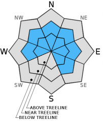
Today, expect overall CONSIDERABLE danger for all avalanche terrain below, near and above treeline. Pockets of HIGH danger are possible on W-NW-N-NE-E-SE slopes near and above treeline. Storm snow since Saturday morning has created new storm and wind slabs that have been easily triggered. Remaining storm/wind slabs that did not slide yesterday could reach there tipping point today with additional new snow and wind loading. Use extreme caution on or near avalanche prone slopes.


Avalanche Problem 1: Wind Slab
-
Character ?

-
Aspect/Elevation ?
-
Likelihood ?CertainVery LikelyLikelyPossible
 Unlikely
 -
Size ?HistoricVery LargeLargeSmall

Wind deposits were numerous yesterday and southerly winds were cranking above treeline, efficiently moving light density snow onto leeward slopes. Small to large wind drifts and wind slabs are certain and likely easily triggered today. Be able to identify where wind loading has taken place. Cornices, blowing snow, wind pillows soft to hard are all great signs that wind loading is present. Avalanche terrain near and above treeline are the areas of most concern, but do not forget about lower angle run out zones. Even though the terrain under your feet may not be a steep slope, it could be connected to a steep slope and you could be in harms way.
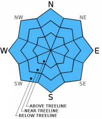
Avalanche Problem 2: Storm Slab
-
Character ?

-
Aspect/Elevation ?
-
Likelihood ?CertainVery LikelyLikelyPossible
Unlikely
-
Size ?HistoricVery LargeLargeSmall
The chances of triggering a small to medium size soft slab are good today with the lighter density snow that is falling. Storm slabs will continue to form from rapid precipitation rates. Near treeline, in areas that are protected from the wind, will be the best places to find unstable storm slabs. It's worth mentioning that the slight increase in temperature today could result in heavier snow and thus, the "upside down cake" effect...heavy snow on top of lighter snow. This means another reason to simply play it safe out there.
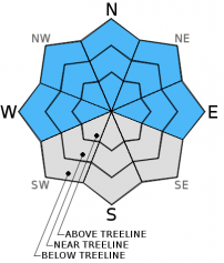
Avalanche Problem 3: Cornice
-
Character ?

-
Aspect/Elevation ?
-
Likelihood ?CertainVery LikelyLikelyPossible
Unlikely
-
Size ?HistoricVery LargeLargeSmall
Continued cornice development today and tomorrow is certain. The bottom line: stay back, well away from the edge. Identify terra firma like trees or rocks protruding from the snow and keep to those areas. Cornices, small to large, can break and also trigger a slide below. If you're with it, game over.
Recent Observations
Holy snow storm! Yesterday proved to be quite the event with heavy snow falling all the way to city limits at times. The early morning started off somewhat benign but by day break, instant heavy precipitation began to fall and didn't stop all day long. At one point, the Old Ski Bowl weather station recorded 3 inches of snow in one hour. A 24 hour total of 13 inches was recorded with a storm total of 19 inches (Last 48 hours) While the Gray Butte wind speed sensor is down, winds have been moderate to strong, southwesterly in nature, loading all easterly and northerly aspects.
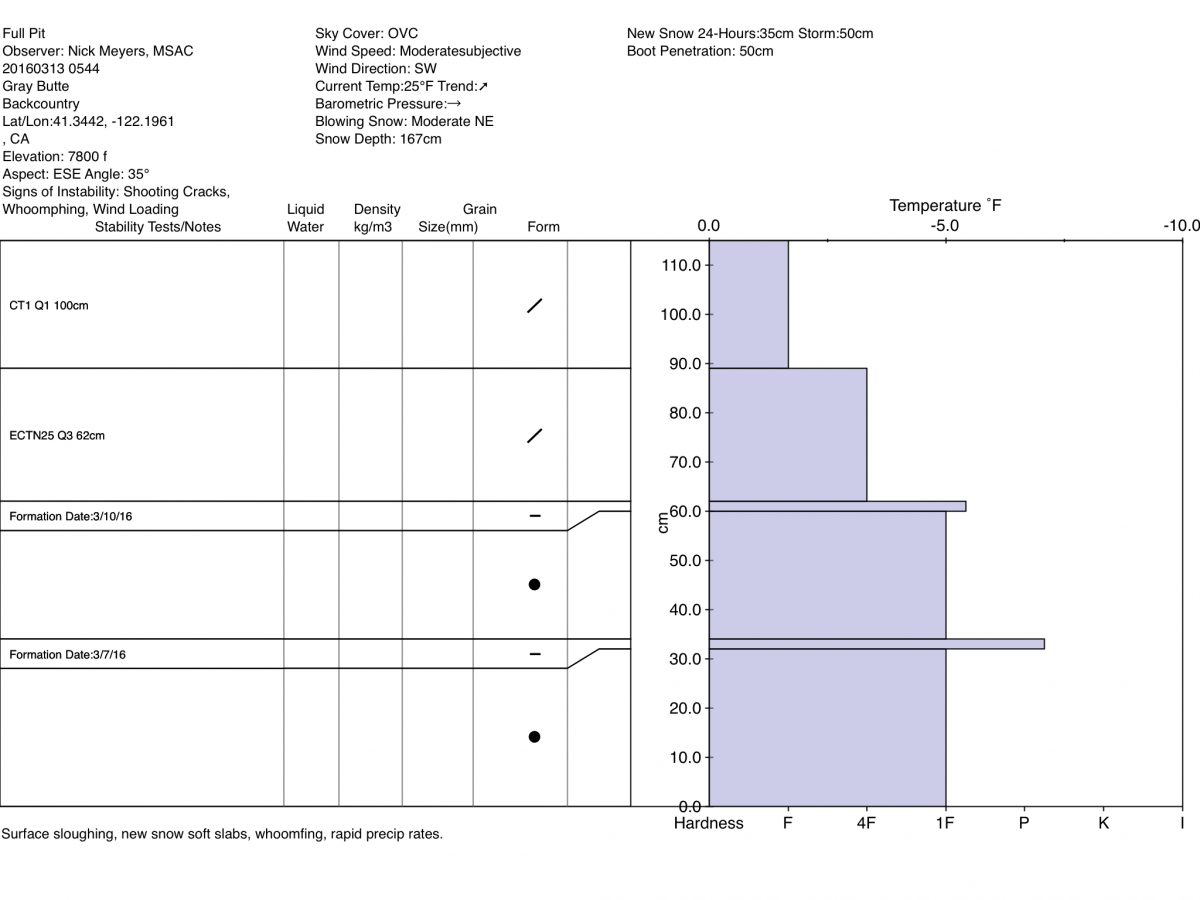
Yesterday, I didn't have to surmise anything regarding the avalanche danger because Mother Nature provided all the obvious clues of instability, free of charge. Instabilities were widespread with shooting cracks, whoomfing, easily triggered storm slabs on small test slopes, wind loading and heavy precipitation observed throughout the day. No large avalanches were observed, though the visibility was once again poor. On southerly aspects, whoomfing was heard by several. All aspects, small to medium size soft slabs (5-25cm thick) were easily triggered . Cracking of wind slabs was also easily obtained near and above treeline where wind pillows/formations had built quickly. (photo below)
While there are several potential sliding interfaces in the snowpack from the past week including the 3/7 and 3/10 crust layers, instabilities from everything I've observed will be confined to within the new snow layers, above the 3/10 crust. It is possible that an avalanche could step down into deeper layers, however from all observations and stability tests, the main weakness lies within the new snow from this weekend. It's likely that many avalanches occured immediately during the storm yesterday.
Concern lies for the degree or two temperature rise today. More precip with heavier snow / higher snow levels could mean the "upside down cake" effect. Whether the new snow over the past 48 hours has settled out or remains stressed is a bit uncertain. For those slide paths that did not release, today could be the day. Continue to stay off avalanche terrain and play it safe.
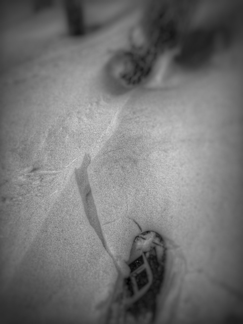
Gray Butte, South side, 7,500ft, 3.12.16
-----------------------------------------------------------------------------------------------------------------------------------------------------------
LOCAL AREA ROAD, NORDIC, AND SNOWMOBILE PARK STATUS:
The Sand Flat cross country ski trails are in good shape and ready for your cross country skis and snow shoes. These are backcountry routes marked with blue diamonds on trees. Trails are not groomed. Snow shoers, please blaze a parallel trail to cross country skiers staying out of the skin track. These trails can be accessed via the Everett Memorial Highway. Thank you, and enjoy!
The Mt. Shasta Nordic Center is open! These beautiful, groomed trails can be accessed via the Ski Park Highway. http://www.mtshastanordic.org
The Pilgrim Creek & Deer Mountain Snowmobile Parks are open! Trails have not been groomed in the past week and a half due to warm temperatures. Head to our "Education" tab on our website and find the snowmobile section for trail information, grooming status, and other sledder resources.
The Castle Lake Road is CLOSED at the gate. The culvert blew out and we do not know when it will be repaired. The Everett Memorial Highway is plowed to Bunny Flat.
The Five Red Flags of Avalanche Danger any time of year include: 1) Recent/current avalanche activity 2) Whumphing sounds or shooting cracks 3) Recent/current heavy snowfall 4) Strong winds transporting snow 5) Rapid warming or rain on snow.
Weather and Current Conditions
Weather Summary
Good Morning! In Mt Shasta City at 0500, we have a current temperature of 38 F, one degrees warmer than yesterday at this time. Skies are obscured with light rain falling at times, breezy.
On Mt Shasta (South Side) in the last 24 hours...
Old Ski Bowl - 7,600 feet, the current temperature is 24 degrees F. Snow on the ground totals 167 inches with 13 inches new snow and little settlement. Temperatures have ranged from 21 F to 25 F.
Gray Butte - 8,000 feet, the current temperature is 23 degrees F. Temperatures have ranged from 20 F to 24 F. Winds have been southwesterly. The speed sensor heaters are not working and the unit is riming. Current winds speeds are not accurate. Directional sensor is however accurate at this time. Working on fixing this. Thanks for understanding.
Mt Eddy Range (West side of Interstate-5)...
Castle Lake - 5,600 feet, the current temperature is 29 degrees. Temperatures have ranged from 26 F to 31 F. Snow on the ground totals 86 inches with 14 inches new snow and little settlement.
Mt Eddy - 6,500 feet, the current temperature is 27 degrees F. Temperatures have ranged from 23 F to 29 F. Snow on the ground measures 102 inches with 11 inches new snow and little settlement. Winds have been southerly in nature. The wind sensor is also not functioning, rimed up perhaps. Working on fixing this one as well. :/
Always check the weather before you attempt to climb Mt Shasta. Further, monitor the weather as you climb. Becoming caught on the mountain in any type of weather can compromise life and limb. Be prepared.
---------------------------------------------------
WEATHER DISCUSSION:
If anybody was impressed with yesterdays high flying storm action, then you won't be let down today because there is more of that coming! Even though precipitation really hasn't let up much, we've hit a bit of a break in the storm this morning. That break will soon give way to another front pushing on shore bringing a second round of wind, rain and snow that will finish off the weekend for us. Monday, we'll still see some post-frontal showers peppering the area. For the remainder of the weekend however, we're looking at an additional 1.38 inches of water by Monday. Temperatures are a degree or two warmer this morning and that will affect snow levels. I witnessed snow down to Mt Shasta City yesterday...perhaps with some intense precipitation rates that could happen again, but it is more likely for the snow level to stay above town, around the 4 to 5,000 foot level. It will cool back off late today and a few inches of accumulation could occur in city limits from the post frontal showers. All in all, expect more snow with slightly higher snow levels, cooling tonight and tapering showers into Monday. Winds will continue out of the south/southwest averaging 20-30 mph with gusts to 40-50 mph above treeline. Below and near treeline, winds speeds will be less. Be safe out there!
THIS SEASON PRECIPITATION for MT SHASTA CITY: Since October 1st (the wet season), we have received 34.53 inches of water, normal is 32.37 inches, putting us at 106% of normal. For the month of March we've received 9.01 inches of water, normal is 2.87 inches, putting us at 313% of normal, and finally... for the year of 2016 we've received 25.04 inches of water, normal is 17.16 inches, putting us at 145% of normal .
| 0600 temperature: | 28 |
| Max. temperature in the last 24 hours: | 29 |
| Average wind direction during the last 24 hours: | Southerly |
| Average wind speed during the last 24 hours: | n/a mi/hr |
| Maximum wind gust in the last 24 hours: | n/a mi/hr |
| New snowfall in the last 24 hours: | 12 inches |
| Total snow depth: | 119 inches |
Two Day Mountain Weather Forecast
Produced in partnership with the Medford NWS
| For 7000 ft to 9000 ft | |||
|---|---|---|---|
|
Sunday (4 a.m. to 10 p.m.) |
Sunday Night (10 p.m. to 4 a.m.) |
Monday (4 a.m. to 10 p.m.) |
|
| Weather | Snow. High near 31. Windy, with a south wind 24 to 33 mph, with gusts as high as 50 mph. Chance of precipitation is 100%. New snow accumulation of 7 to 11 inches possible. | Snow showers. Low around 20. Windy, with a southwest wind 24 to 30 mph, with gusts as high as 45 mph. Chance of precipitation is 100%. New snow accumulation of 3 to 7 inches possible. | Snow showers likely. Mostly cloudy, with a high near 20s. South southwest wind 15 to 18 mph, with gusts as high as 29 mph. Chance of precipitation is 70%. New snow accumulation of 1 to 3 inches possible. |
| Temperature (°F) | 31 | 20 | 25 |
| Wind (mi/hr) | South 15-20 mph | Southwest 15-20 mph | South/Southwest 20-25 mph |
| Precipitation SWE / Snowfall (in) | / 7-11 | / 3-7 | / 1-3 |
| For 9000 ft to 11000 ft | |||
| Sunday | Sunday Night | Monday | |
| Weather | Snow. The snow could be heavy at times. High near 17. Wind chill values as low as -10. Windy, with a south southwest wind 50+ mph with gusts higher in exposed areas. Chance of precipitation is 100%. New snow accumulation of 17 to 23 inches possible. | Snow showers. The snow could be heavy at times. Low around 9. Wind chill values as low as -25. Windy, with a west southwest wind 40-50 mph with gusts higher in exposed areas. Chance of precipitation is 100%. New snow accumulation of 6 to 10 inches possible. | Snow showers likely. Mostly cloudy and cold, with a high near 15. Wind chill values as low as -25. Windy, with a west wind 40-50 mph with gusts higher in exposed areas. Chance of precipitation is 70%. New snow accumulation of 2 to 4 inches possible. |
| Temperature (°F) | 17 | 9 | 15 |
| Wind (mi/hr) | South/Southwest 50+ mph | West/Southwest 17-23 | West 40-50 mph |
| Precipitation SWE / Snowfall (in) | / 17-23 | / 6-10 | / 2-4 |

