

You are here
Avalanche Advisory for 2016-03-24 06:57:13
- EXPIRED ON March 25, 2016 @ 6:57 amPublished on March 24, 2016 @ 6:57 am
- Issued by Nick Meyers - Shasta-Trinity National Forest
Bottom Line
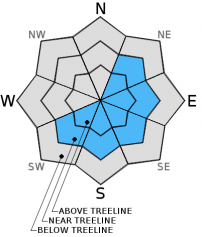
For most slopes in the forecast area, LOW avalanche danger will exist.
Near and above treeline, strong northwest flow aloft has created new wind slabs in the past 24 hours and will continue today. Human triggered wind slabs along ridgelines, bowls, near rock outcroppings and steep chutes are possible and MODERATE avalanche danger exists for these wind loaded pockets. Small/medium size avalanches are possible and most likely to be found on SW-S-SE-E-NE facing slopes. Identify wind loading, proceed cautiously.


Avalanche Problem 1: Wind Slab
-
Character ?

-
Aspect/Elevation ?
-
Likelihood ?CertainVery LikelyLikelyPossible
 Unlikely
 -
Size ?HistoricVery LargeLargeSmall

Strong northwest flow aloft created a giant plume of blowing snow visible from town yesterday off Casaval and other ridgelines on Mt Shasta. Continued, strong northwest flow will again blow snow around today and could create new wind slabs or build on yesterdays slabs on leeward SW-S-SE-E-NE facing slopes. The northwesterlies will prevail through Saturday morning. Ridgelines, depressions, moraine convexities, rock outcroppings, steep and narrow couloirs are all great places for wind to form eddies and snow to stack up. Wind can load slopes 10x faster than snow falling from the sky... and even though it's not snowing out and the sky may be blue, wind slabs are still possible. For exposed ridgelines where wind speeds are greatest, non-typical starting zones might exist where wind has blown snow down further on the slope... mid-slope starting zones, as opposed to classic ridgeline wind loading. The most concern for these potentially unstable pockets of wind loading will be above treeline on Mt Shasta. Also be cautious near treeline where wind can still be present.
Forecast Discussion
A disturbance is moving through into NW Washington this morning and will affect parts of NE Oregon by this evening. Crater Lake area could see an inch of snow or thereabouts. Northwest flow aloft will bring showers to Southern Oregon through Friday. The next front is on track to bring precipitation on Saturday. Snow levels are predicted to be in the 5,500 to 6,000 foot range but will lower to 4,000 to 4,500 feet by Sunday. Easter Sunday will be cool and showery for just about all the forecast area as a closed low slides south over the area. Unsettled weather continues into Tuesday but a blocking ridge is expected to bring a warming and drying trend to our area in the second half of next week. (NWS Medford)
THIS SEASON PRECIPITATION for MT SHASTA CITY: Since October 1st (the wet season), we have received 36.72 inches of water, normal is 34.36 inches, putting us at 106% of normal. For the month of March we've received 11.20 inches of water, normal is 4.86 inches, putting us at 230% of normal, and finally... for the year of 2016 we've received 27.23 inches of water, normal is 19.15 inches, putting us at 142% of normal.
Recent Observations
Variable and transitional are a couple words that I've heard from different local skiers and riders who have been getting out the past few days. The week started off with a decent dollop of snow, 7-12 inches recorded over most of the forecast area. It was followed by cool temperatures that struggled to get above freezing. Yesterday and today were much warmer and the warm temperatures have consolidated the snow another 2-3 inches. The avalanche hazard continues to diminish. No recent avalanches/signs of instability have been reported or observed. On shaded, northerly aspects, powder can be found if free from wind and any solar. Once in the open however, variable supportable crust held decent skiing once a little bit of sun hit it. Below treeline and most lower elevations, a widespread supportable crust about 1 inch thick exists on southerly aspects. In the alpine areas, near and above treeline, wind has done its work by scouring ridgelines to old, hard snow/ice and created wind packed powder in bowls. Small to large sastrugi features can be found also, dispersed above treeline.
In the Castle Lake area yesterday, a few broken cornices off the ridge line were noted, as well as one small point release slide from earlier this week. For today, the main concern is for newly formed wind slabs above treeline on Mt Shasta. Both yesterday and this morning, northwest winds were cranking across the mountain and as mentioned, a giant plume of billowing snow could be seen off of Casaval Ridge while cruising down Interstate 5. What is the best sign of wind loading? Visible blowing snow! So... all leeward ridgelines above treeline, little pockets around chutes, rock outcroppings or any other feature that could create a wind eddy and allow for new wind blown snow to stack up... that is your concern today. These little pockets could be triggered by a skier or rider. The size of these wind pockets could be very small to medium in size, certainly enough to bury a person. Most slopes in the forecast area are going to be free of worry, but once you start to get into steeper terrain where wind loading has occurred, especially on Mt Shasta, be careful. Again, winds have been northwesterly, so slopes SW-S-SE-E-NE facing should be where most wind loading has taken place.
Loose wet related instabilities are a possibility at lower elevations today but not expected to be a major concern as a bit of cloud cover and moderate temps will keep most of the snow in place. That said, we are on the forefront of spring and loose wet avalanches will become a concern in the coming future.
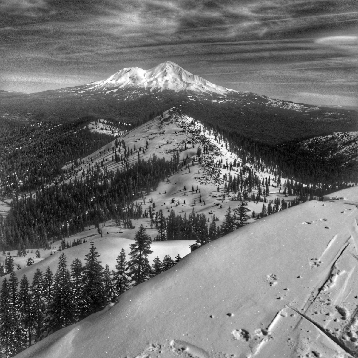
Mt Shasta, viewed from the top of the Castle Lake area on 3.23.16 - Photo: J Koster
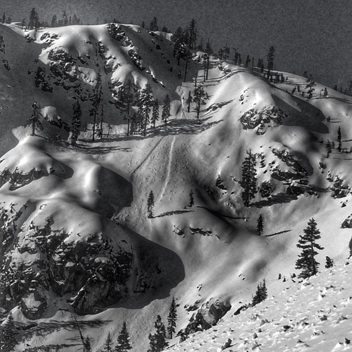
The Castle Lake area from below, 3.23.16, with small point release visible. Photo: J Koster
A note for all climbers and skiers heading up onto the upper mountain: Rime ice has formed on most rock outcroppings and is currently very thick. As warm days ensue, rime ice will flake off and fall down onto the slopes below. Rime ice chunks can be very large and very hard, enough to potentially kill you or cause serious injury. Beware of this hazard. Keep your eyes up slope as you climb and move laterally to avoid falling chunks of ice. If continuous ice fall is encountered turn around and descend to climb another day!
-----------------------------------------------------------------------------------------------------------------------------------------------------------
LOCAL AREA ROAD, NORDIC, AND SNOWMOBILE PARK STATUS:
The Sand Flat cross country ski trails are in good shape and ready for your cross country skis and snow shoes. These are backcountry routes marked with blue diamonds on trees. Trails are not groomed. Snow shoers, please blaze a parallel trail to cross country skiers staying out of the skin track. These trails can be accessed via the Everett Memorial Highway. Thank you, and enjoy!
The Mt. Shasta Nordic Center is open! These beautiful, groomed trails can be accessed via the Ski Park Highway. http://www.mtshastanordic.org
The Pilgrim Creek & Deer Mountain Snowmobile Parks are open! Trails have not been groomed in the past week and a half due to constant deep snow fall. Head to our "Education" tab on our website and find the snowmobile section for trail information, grooming status, and other sledder resources.
The Castle Lake Road is OPEN. The Everitt Memorial Highway is OPEN. The Castle Lake and Everitt Hwy are plowed year round to the trailheads. The roads are not always first priority, so your dawn patrol powder mission might be ceased if the plow has not made it up yet. Siskiyou County does a great job keeping the roads clear and be respectful of the plow drivers if you encounter them. If you get to Bunny Flat before or during when the plow is there, please park on the uphill, LEFT side of the parking lot as you drive in. This is uphill and lookers right of the bathrooms. Thank You!
The Five Red Flags of Avalanche Danger any time of year include: 1) Recent/current avalanche activity 2) Whumphing sounds or shooting cracks 3) Recent/current heavy snowfall 4) Strong winds transporting snow 5) Rapid warming or rain on snow.
Weather and Current Conditions
Weather Summary
Good Morning! In Mt Shasta City at 0500, we have a current temperature of 37 F, 7 degrees warmer than yesterday at this time. Skies are partly cloudy with calm wind.
On Mt Shasta (South Side) in the last 24 hours...
Old Ski Bowl - 7,600 feet, the current temperature is 33 degrees F. Snow on the ground totals 161 inches with no new snow and 2 inches of settlement. Temperatures have ranged from 19 F to 45 F.
Gray Butte - 8,000 feet, the current temperature is 31 degrees F. Temperatures have ranged from 19 F to 37 F. Winds have been light and variable until 1900, then the northwesterlies picked up averaging 20-30 mph with gusts to 49 mph.
Mt Eddy Range (West side of Interstate-5)...
Castle Lake - 5,600 feet, the current temperature is 34 degrees F. Temperatures have ranged from 23 F to 49 F. Snow on the ground totals 77 inches with no new snow and 1.5 inches settlement.
Mt Eddy - 6,500 feet, the current temperature is 33 degrees F. Temperatures have ranged from 18 F to 41 F. Snow on the ground measures 90 inches with no new snow and 2.5 inches of settlement. Winds have been southerly in nature with an average of 2-3 mph, and a maximum gust of 9 mph.
Always check the weather before you attempt to climb Mt Shasta. Further, monitor the weather as you climb. Becoming caught on the mountain in any type of weather can compromise life and limb. Be prepared.
| 0600 temperature: | 35 |
| Max. temperature in the last 24 hours: | 41 |
| Average wind direction during the last 24 hours: | Variable until 1900, then Northwest |
| Average wind speed during the last 24 hours: | 10-15 mi/hr |
| Maximum wind gust in the last 24 hours: | 49 (Gray Butte) mi/hr |
| New snowfall in the last 24 hours: | 0 inches |
| Total snow depth: | 104 inches |
Two Day Mountain Weather Forecast
Produced in partnership with the Medford NWS
| For 7000 ft to 9000 ft | |||
|---|---|---|---|
|
Thursday (4 a.m. to 10 p.m.) |
Thursday Night (10 p.m. to 4 a.m.) |
Friday (4 a.m. to 10 p.m.) |
|
| Weather | Mostly sunny, with a high near 46. West northwest wind 10 to 20 mph, with gusts as high as 30 mph. | Partly cloudy, with a low around 29. Northwest wind around 10-15 mph, with gusts as high as 25 mph. | Mostly sunny, with a high near 42. Northwest wind 15 to 20 mph, with gusts as high as 30 mph. |
| Temperature (°F) | 46 | 29 | 42 |
| Wind (mi/hr) | West/Northwest 10-20 mph, gusts to 30 mph | Northwest 10-15 mph with gusts to 25 mph | Northwest 15-20 mph, gusts to 30 mph |
| Precipitation SWE / Snowfall (in) | / 0 | / 0 | / 0 |
| For 9000 ft to 11000 ft | |||
| Thursday | Thursday Night | Friday | |
| Weather | Mostly sunny, with a high near 25. Windy, with a west northwest wind 30 to 40 mph with gusts higher. | Partly cloudy, with a low around 24. Windy, with a northwest wind 30 - 40 mph with gusts higher. | Mostly sunny, with a high near 26. Windy, with a north northwest wind 30-40mph, with gusts higher. |
| Temperature (°F) | 25 | 22 | 26 |
| Wind (mi/hr) | West/Northwest 30-40 mph with gusts higher in exposed areas | Northwest 0 | North/Northwest 30-40 mph with gusts higher in exposed areas |
| Precipitation SWE / Snowfall (in) | / 0 | / 0 | / 0 |

