

You are here
Avalanche Advisory for 2016-04-01 06:35:38
- EXPIRED ON April 2, 2016 @ 6:35 amPublished on April 1, 2016 @ 6:35 am
- Issued by Nick Meyers - Shasta-Trinity National Forest
Bottom Line
This morning, LOW avalanche danger will prevail for all elevations and aspects. As daytime warming occurs, MODERATE danger is likely for loose-wet related instabilities on sunny slopes. Aspects E-SE-S-SW below 10,000 feet will host the best chance for human triggered loose-wet rollerballs, pinwheels and perhaps a larger point release loose wet slide. Some natural loose wet activity is possible today. Calm winds and warm temperatures will persist, allowing for high solar gain on the snowpack.


Avalanche Problem 1: Loose Wet
-
Character ?

-
Aspect/Elevation ?
-
Likelihood ?CertainVery LikelyLikelyPossible
 Unlikely
 -
Size ?HistoricVery LargeLargeSmall

Temperatures are several degrees warmer today from yesterday, and the wind is calm. Overnight lows barely reached 32 degrees. This will allow for better warming of sun exposed slopes and human triggered loose-wet activity is defintely possible today, especially on east, southeast and south aspects. We did not see much loose-wet activity yesterday. The chance for loose-wet activity today is better due to warmer temperatures, however with a decent overnight re-freeze, chances of a larger loose-wet slide are slim. During the mid afternoon hours, if you start to see roller balls and pinwheels, this is a freebie from mother nature... an early warning sign of unstable snow and indicator that, especially if the warming continues and/or there are sunny hours left in the day, that larger loose-wet avalanches are possible. Those early warning signs are your cue to move onto shadier slopes or come back another day. Early signs of loose-wet instability can seem like not a big deal... big pin wheels are fun to watch and oolge over...though watch a giant loose wet slide snake its way down Avalanche Gulch, crossing climbers gully and piling up in a gully bottom (terrain trap) and the message is clear! Loose wet slides can be serious. Loose snow has little or no cohesion. Loose snow avalanches form near the surface and they involve near-surface snow on initiation. Once the descent starts, subsurface snow beneath the surface may be swept along, particularly if the snow is wet. Wet loose snow avalanches can be much more massive than dry ones. Shasta hosts long, consistently pitched slopes allowing for a lot of snow to become entrained as a loose wet avalanche builds size and momentum. Take these types of avalanches seriously and heed the warning signs. Loose wet slides are difficult to predict. Pay attention to early warning signs and best to play it safe.
Forecast Discussion
Spring is beginning to spring and it sure does feel good. Winter is awesome, no doubt about that. However, warm rays of the sun soaking into the skin, hiking in a t-shirt, flip flops apres ski, hanging out in the parking lot reveling at the days corn skiing...that is awesome too. We are lucky to be able to experience each seasonal change. If you missed out on any of the last gorgeous several days, you're in luck... today will be much the same. No fooling. (Happy April Fool's Day by the way!) One big giant blue sky will be all that is in view for today. Mountain winds will also be light and variable. This weekend, a couple weak systems will move into the region. Scattered showers and partly cloudy skies should be the main effect with increasing wind speeds Saturday afternoon and Sunday/Monday. Precipitation amounts look minimal. While the overall weather in the region this weekend could be partly cloudy, the upper mountain can often be shrouded with a dense cloud cap. Climbing into a white-out is never a safe or good idea and we do not recommend it. Experienced guides have become lost in poor visibility conditions on the upper mountain. Once you gain the upper mountain, above approximately 12,500 feet, it is very easy to accidentally descend off the wrong side of the mountain. This has happended many times before and is easily prevented. Should that happen, one will find themselves in potentially steep, glaciated terrain and it makes for a very long day (and night perhaps) for climber, fellow party members, family and rescue resources. Play it safe and do not climb into a white-out.
CLIMBERS & SKIERS:
We are on the edge of climbing season for Mount Shasta. As April and May roll around, this is when we typically get the most climber and skier traffic, AND it is when we get most of our accidents. Conditions right now are fantastic, but with that comes risk. The mountain is completely covered in snow and rime ice. While the rockfall potential is low, other hazards exist.
In no particular order...
First, weather... Late Winter and Spring can offer the full gammut of weather conditions - winter blizzards, howling wind, freezing cold to beautiful sunny days with flip flops and brews in the parking lot. You need to bring the appropriate attire to accomodate all these weather conditions.
Avalanche danger can also rise and fall quickly with passing storms resulting in wind slabs on top of firm, melt/freeze snow and also loose wet related instabilities on those warm days. An avalanche beacon, shovel and probe are essential.
As for the climbing, the snow surface conditions are currently very smooth and very firm. If you slip and fall, you WILL take a long slide for life if you do not immediately self-arrest. A helmet, ice axe and crampons essential! (A hiker slipped and fell on Spring Hill a few days ago, sliding into a tree, breaking a leg/hip... yes, the snow is smooth and firm!)
Lastly, exposed rocks are currently plastered in rime ice. This rime ice will break off and tumble downhill onto climbers and skiers on warm days, sometimes taking rock with it. The rime ice chunks can be just as hard as rock and cause serious inury.
Thus, full winter mountaineering conditions exist and a climb of Mt Shasta should not be taken lightly. Our goal is not scare tactics here, but to provide accurate, up to date and factual information so you can plan and prepare for a safe adventure on Mt Shasta, returning home in one piece. For your best chances at a safe climb, be sure you have the proper equipment (ice axe, crampons, helmet, avalanche transceiver, shovel, and probe) and know how to use all of it. Check the weather. Make sound decisions. Keep your group together. Know how to self-arrest. Please call us if you have further questions. 530-926-4511
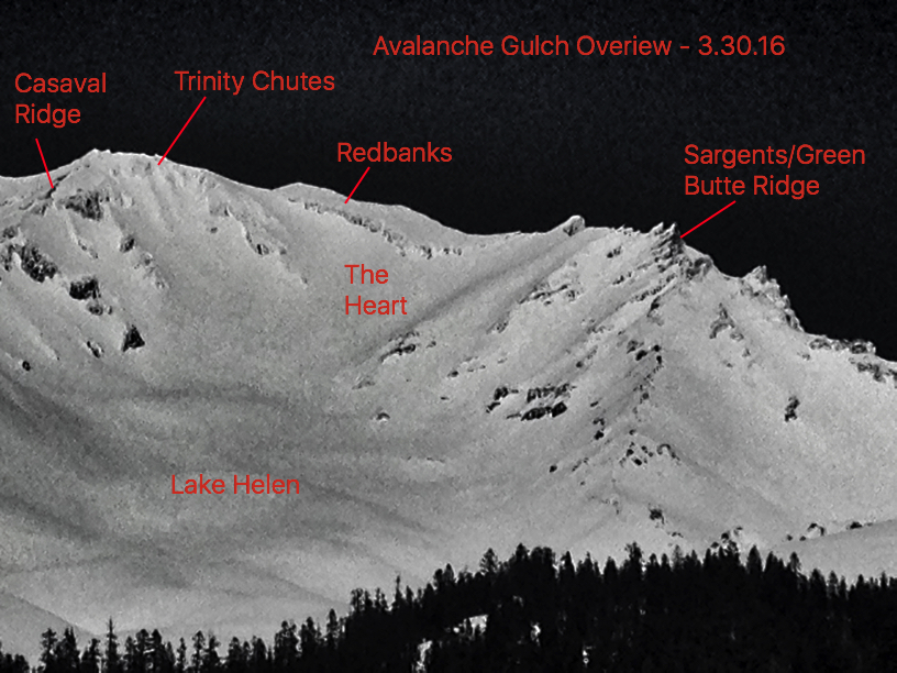
Avalanche Gulch Overview, photo taken on 3.30.16. Note the heavily rimed rocks (Redbanks, Trinity Chutes, Sargents/Casaval ridges) - Meyers
THIS SEASON PRECIPITATION for MT SHASTA CITY: Since October 1st (the wet season), we have received 36.73 inches of water, normal is 35.46 inches, putting us at 103% of normal. For the month of March we've received 11.21 inches of water, normal is 5.96 inches, putting us at 188% of normal, and finally... for the year of 2016 we've received 27.24 inches of water, normal is 20.25 inches, putting us at 134% of normal.
Recent Observations
Temperatures have been slowly climbing over the week. This morning, temperatures are 4 to 6 degrees warmer than yesterday morning. Temperatures reported from local weather stations reached highs in the 50's yesterday and today they will remain near the same, perhaps a tad warmer. Castle lake climbed to 59 degrees at 10am! Overnight, good radiational cooling and near freezing low's should give the snowpack a good re-freeze. Very few loose-wet instabilities were observed yesterday despite the warm temperatures. As mentioned, the chance for loose-wet activity today is better due to warmer temperatures, however with a decent past overnight re-freeze, chances of a larger loose-wet slide are slim. Lower elevation avalanche terrain that experienced less of a freeze will have the best chance of showing signs of loose-wet instability. All said, problamatic large loose-wet slides do not seem likely today.
Firm snow conditions in the morning with softening on sun exposed slopes in the afternoon can be found at lower and mid elevations (below approximately 10,000 feet). Upper elevations and shadier aspects hold smooth, scoured snow with scabs of sastrugi and wind effected, packed powder. Where corn snow is present, riding conditions have been fantastic.
Enjoy the backcountry as the melt/freeze cycle begins! Be sure to stay on your game this Spring... larger loose-wet slides happen every year on Shasta and can become large enough to cause serious harm. Along with this, falling rime ice and rocks necessitate the need for a helmet. Last, a slide for life on firm, smooth snow in the AM hours is possible....thus an ice axe and self arrest skills are absolutely required. These are some hazards not typically associated with winter conditions. Take note, be prepared, have fun!

Climbers Gully in Avalanche Gulch with distant turns off Casaval Ridge, 3.31.16 - Photo: C Carr
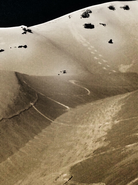
Same shot, close-up, Climbers Gully in Avalanche Gulch. Note sastrugi wind deposited feature in gully bottom. 3.31.16 - Photo: C Carr
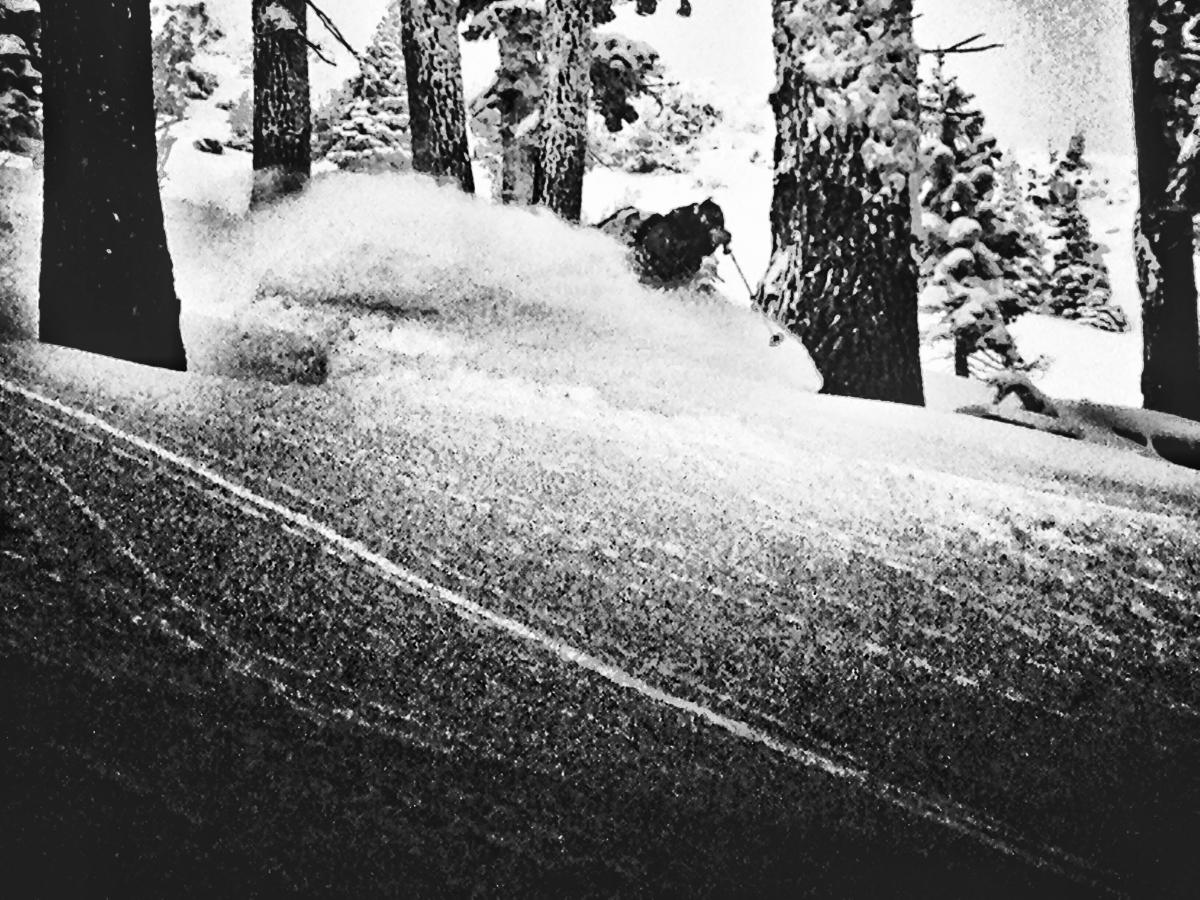
Some great powder can still be found if you hunt for it on northerly aspects. Here, a local finds a stash near treeline - ;) Happy April Fools Day!
-----------------------------------------------------------------------------------------------------------------------------------------------------------
LOCAL AREA ROAD, NORDIC, AND SNOWMOBILE PARK STATUS:
The Sand Flat cross country ski trails are in good shape still and ready for your cross country skis and snow shoes. These are backcountry routes marked with blue diamonds on trees. Trails are not groomed. Snow shoers, please blaze a parallel trail to cross country skiers staying out of the skin track. These trails can be accessed via the Everett Memorial Highway. Thank you, and enjoy!
The Mt. Shasta Nordic Center is CLOSED for the season. http://www.mtshastanordic.org
The Pilgrim Creek & Deer Mountain Snowmobile Parks are open, however snow is dwindling fast at these locations. One had to drive down the 19 road (Military Pass) a mile or so to get to consistent snow before unloading just a few days ago. Head to our "Education" tab on our website and find the snowmobile section for trail information, grooming status, and other sledder resources.
The Castle Lake Road is OPEN. The Everett Memorial Highway is OPEN. The Castle Lake and Everett Hwy are plowed year round to the trailheads. The roads are not always first priority, so your dawn patrol powder mission might be ceased if the plow has not made it up yet. Siskiyou County does a great job keeping the roads clear. Be respectful of the plow drivers if you encounter them. If you get to Bunny Flat before or during when the plow is there, please park on the uphill, LEFT side of the parking lot as you drive in. This is uphill and lookers right of the bathrooms. Thank You!
The Five Red Flags of Avalanche Danger any time of year include: 1) Recent/current avalanche activity 2) Whumphing sounds or shooting cracks 3) Recent/current heavy snowfall 4) Strong winds transporting snow 5) Rapid warming or rain on snow.
Weather and Current Conditions
Weather Summary
Good Morning! In Mt Shasta City at 0500, we have a current temperature of 39 F, five degrees warmer than yesterday at this time. Skies are clear with calm wind.
On Mt Shasta (South Side) in the last 24 hours...
Old Ski Bowl - 7,600 feet, the current temperature is 37 degrees F. Snow on the ground totals 149 inches with no new snow and 2 inches of settlement. Temperatures have ranged from 32 F to 50 F.
Gray Butte - 8,000 feet, the current temperature is 41 degrees F. Temperatures have ranged from 35 F to 50 F. Wind speeds are not available for Gray Butte at this time. The anemometer was taken down due to the need for repairs. Thank you for your understanding.
Mt Eddy Range (West side of Interstate-5)...
Castle Lake - 5,600 feet, the current temperature is 42 degrees F. Temperatures have ranged from 37 F to 59 F. Snow on the ground totals 70 inches with no new snow and 1 inches settlement.
Mt Eddy - 6,500 feet, the current temperature is 36 degrees F. Temperatures have ranged from 30 F to 51 F. Snow on the ground measures 81 inches with no new snow and 2 inches settlement. Winds have been southerly in nature with an average of 2 mph, and a maximum gust of 9 mph.
Always check the weather before you attempt to climb Mt Shasta. Further, monitor the weather as you climb. Becoming caught on the mountain in any type of weather can compromise life and limb. Be prepared.
| 0600 temperature: | 32 |
| Max. temperature in the last 24 hours: | 51 |
| Average wind direction during the last 24 hours: | N/A |
| Average wind speed during the last 24 hours: | N/A mi/hr |
| Maximum wind gust in the last 24 hours: | N/A mi/hr |
| New snowfall in the last 24 hours: | 0 inches |
| Total snow depth: | 94 inches |
Two Day Mountain Weather Forecast
Produced in partnership with the Medford NWS
| For 7000 ft to 9000 ft | |||
|---|---|---|---|
|
Friday (4 a.m. to 10 p.m.) |
Friday Night (10 p.m. to 4 a.m.) |
Saturday (4 a.m. to 10 p.m.) |
|
| Weather | Sunny, with a high near 57. Light and variable wind becoming south around 6 mph in the afternoon. | Mostly clear, with a low around 37. West southwest wind 0 to 5 mph. | A 20 percent chance of showers after 11am. Mostly sunny, with a high near 53. South southwest wind 6 to 10 mph. |
| Temperature (°F) | 57 | 37 | 53 |
| Wind (mi/hr) | Light and variable, becoming south 0-5 mph | West/Southwest 0-5 mph | South/Southwest 5-10 mph |
| Precipitation SWE / Snowfall (in) | / 0 | / 0 | / 0 |
| For 9000 ft to 11000 ft | |||
| Friday | Friday Night | Saturday | |
| Weather | Sunny, with a high near 32. Northeast wind 5 to 10 mph becoming light and variable in the morning. | Mostly clear, with a low around 31. Light and variable wind becoming south 5 to 10 mph in the evening. Winds could gust as high as 20 mph. | A 20 percent chance of snow showers after 11am. Mostly sunny, with a high near 31. Breezy, with a south southwest wind 15 to 20 mph, gusts higher. |
| Temperature (°F) | 32 | 31 | 31 |
| Wind (mi/hr) | Northeast 5-10 mph | Variable, becoming south 0 | South/Southwest 15-20 mph, gusts to 20-25 mph |
| Precipitation SWE / Snowfall (in) | / 0 | / 0 | / 0 |

