

You are here
Avalanche Advisory for 2016-04-08 06:20:51
- EXPIRED ON April 10, 2016 @ 6:20 amPublished on April 8, 2016 @ 6:20 am
- Issued by Nick Meyers - Shasta-Trinity National Forest
Bottom Line
Poor overnight re-freeze continues however increasing clouds, cooling temperatures and wind will help keep loose wet slides at bay today. LOW avalanche danger this morning exists for all aspects and elevations. Pockets of MODERATE danger may be encountered this afternoon for loose wet avalanches primarily on south and southeast facing slopes steeper than 35 degrees. Roller balls and loose, heavy, wet snow on sunny aspects is the best clue indicating larger loose wet slides are possible.


Avalanche Problem 1: Loose Wet
-
Character ?

-
Aspect/Elevation ?
-
Likelihood ?CertainVery LikelyLikelyPossible
 Unlikely
 -
Size ?HistoricVery LargeLargeSmall

Yesterday we saw some loose wet activity, mostly on southeast facing slopes from treeline to just over 9,000 feet on Mt Shasta. These areas are mostly protected from wind and get a ton of solar. Temperatures still didn't even come close to freezing last night. That said, a few things will aid in keeping the snow in place today:
- Increasing clouds
- Decreasing temperatures
- Wind
Any loose wet slides today will be limited. Expect those southeast aspects to be most suspect near and slightly above treeline. Loose wet slides are often slow moving and of non-consequence, but pair one up with trees or a terrain trap and certainly these types of slides could cause you some trouble. Perhaps not death, but a twisted knee or broken leg are certainlly within the realm of possibility.
An early sign of instability are roller balls, pinwheels and small point release slides. If you find yourself witnessing those early warning signs AND you're on a sunny aspect sweating your you know what off and sinking deeply into wet, heavy, mushy snow... that is your cue to head back to the barn or move onto a shadier aspect for the remainder of the day. Mother Nature often provides these free clues to us to indicate snow instability. Heed those clues as larger loose wet slides are possible.
Typically, south and southeast facing slopes are the most common aspects to see loose wet slides occur on Mt Shasta. That said, east and southwest aspects in other parts of the forecast area could see loose wet activity. Open, sunny slopes that are protected from the wind and are 35 degrees or steeper usually host the best chance of loose wet slides.
It's beginning to be that time of year when the mountain can become quite crowded with other climbers/skiers within your sphere of influence. So, not only should you be concerned about triggering a loose wet slide that you or your group is involved in, you need to pay attention to where other groups are located. Are you above or below another group? Could you trigger a slide on top of somebody or is another skier going to trigger something on top of you? We are talking situational awareness here. Keep yours on high.
Forecast Discussion
I feel comfortable describing yesterday as downright hot! The proof is in the pudding... Medford absolutely shattered an old temperature record yesterday by 8 degrees. Records go back as far as 1911 and this was the earliest 90+ degree weather. In Mt Shasta, we also blew the old record off the books by 7 degrees with a high of 85F. Dang! Depending on whether or not you are more tuned to the likes of a lizard, the fact that things will be cooling down and hot temperatures not revisited for a while may or may not excite you. That is the case however... temperatures will begin to fall and tonight through Sunday the area of low pressure west of California will move into Central and Southern California. Thus, the best dynamics for precipitation will remain to the south, but expect enough instability and moisture to yield showers and isolated thunderstorms Saturday and Sunday afternoons and evenings, mostly from the Cascades and Siskiyous south and eastward. A consistent cooling trend during this time period will continue through mid-week. Wednesday and Thursday look to be the best chance of precipitation with snow levels down below 5,000 feet. More on that later. This weekend, any showers we do get will result in minimal snow amounts. Snow levels will linger around 9 to 10,000 feet and a few inches at best possible for the top half of the mountain. Certainly no powder day, but perhaps enough to help smooth things out a little bit! The long range forecast shows April to host above normal precipitation with near normal temperatures. So, while the latest hot spell felt pretty darn good and jump started everyone's tanning, it should be short lived and unlikely to return soon. (NWS Medford)
THIS SEASON PRECIPITATION for MT SHASTA CITY: Since October 1st (the wet season), we have received 36.76 inches of water, normal is 36.27 inches, putting us at 101% of normal. For the month of April we've received 0.03 inches of water, normal is 0.81 inches, putting us at 3% of normal, and finally... for the year of 2016 we've received 27.27 inches of water, normal is 21.06 inches, putting us at 129% of normal.
Recent Observations
Warm, no... HOT was the best descriptor for yesterday, evident from the numerous loose wet slides on Mt Shasta and the record shattering high temperatures acheived for both Mt Shasta City and Medford. Records were 7 and 8 degrees above the old record highs, respectively. Yesterday, the recipe was good for some loose wet activity and the mountain cooked up several slides shown off Casaval Ridge, Green Butte and Sun Bowl. Common traits for all the loose wet slides that occurred: All were on southeast facing slopes between treeline and 9,200 feet and free of wind. Above this elevation, temps were slightly cooler and a steady breeze helped keep things in place up higher. The loose wet slides observed were both natural and human triggered. Overall, poor re-freeze has created soft and sticky snow on sun exposed slopes below and near treeline. Higher on the mountain, firmer smooth snow and "healing" sastrugi can be found. Rime ice still dominates many rock features and will continue to flake off anytime, but most prone during the warmest portion of the day.
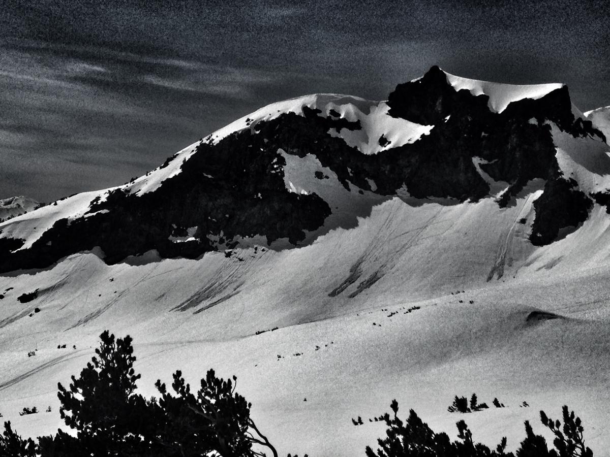
A half dozen or so loose wet slides off the southeast aspect of Green Butte on 4.7.16 - Photo: N Meyers
Several natural and skier triggered loose wets on a southeast aspect of Casaval Ridge into Avalanche Gulch, 4.7.16. Starting zone elevation approx. 9,200 feet - Photo: N Meyers
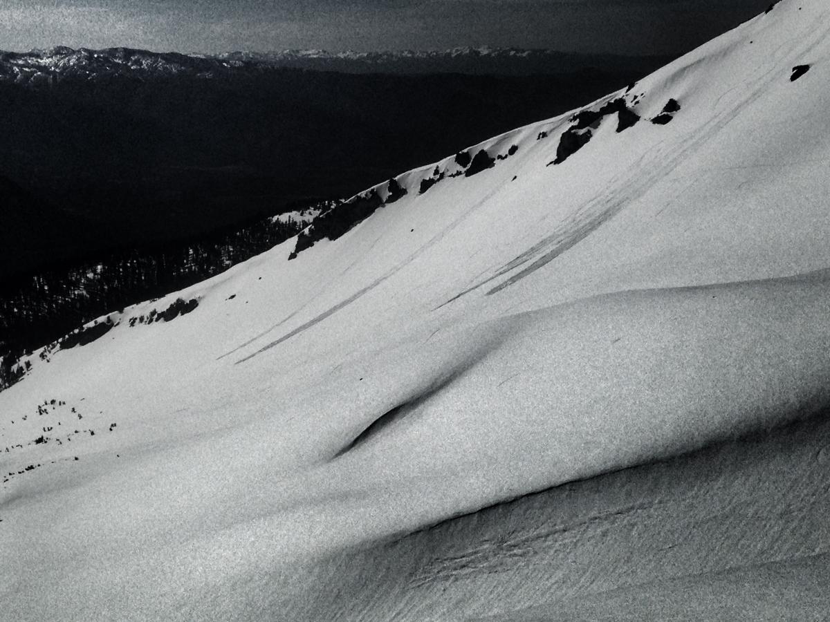
A look up into Avalanche Gulch and Green Butte / Sargents ridge. Conditions were soft and punchy along the ridgeline. 4.7.16 - Photo: N Meyers
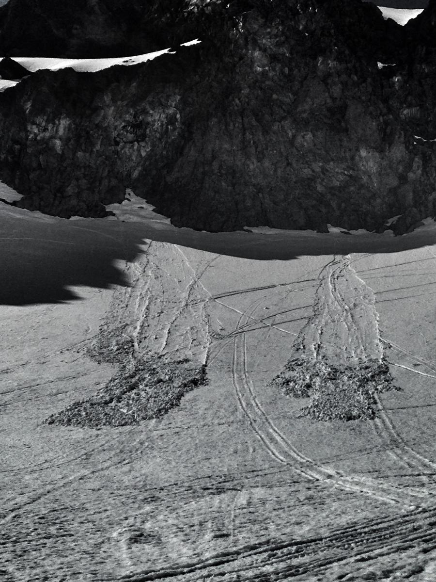
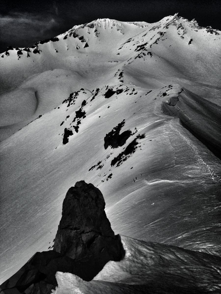
Close-up of loose wet slides off Green Butte, 4.7.16 - Photo: N Meyers
Climbing Conditions: Current climbing conditions are good to great. Steadily increasing temperatures this week with overnight lows above freezing will not allow a solid snow re-freeze at night. This could mean post-holing at lower elevations. At higher elevations (11,000 feet and above), however, snow will refreeze better and be firm in the morning hours making crampons (and ice axe) necessary equipment.
Below are some things to think about when planning your trip this Spring:
- Avalanche Danger & Weather: You may encounter a variety of snow conditions during the spring time. Late season storms can bring fresh snow and high winds to the mountains. Avalanche danger can quickly spike due to new wind and storm slabs on top of icy, firm melt/freeze snow. Further, warm and sometimes downright hot days can create loose wet avalanches. Low danger in the cool morning hours may rise rapidly to higher danger during the afternoon hours on sunny aspects. These are two different avalanche problems associated with different weather patterns with both being possible during the same week, or even the same day. A beacon, shovel and probe continue to be essential, even during Spring time. Always check the avalanche advisory before starting your climb, and call the ranger station for the latest in weather and conditions. Spring time weather patterns can bring it all. The point is... you need to bring the appropriate attire to accommodate all weather conditions. Snow, rain, sun, wind... you can count on all of it on Shasta at some point during Spring time. Further, Mt Shasta can often host a cloud cap creating poor visibility conditions. DO NO climb into a white-out. It is very easy to wander off the WRONG side of Mt Shasta when on the upper mountain, >12,500 feet. This can create a long day and perhaps night for climber, party members, rescue resources and family. Play it safe.
- Firm and smooth snow (slide for life conditions): Snow conditions on Mount Shasta are great right now. That being said, the snow in the morning hours is very firm and very smooth. These types of conditions have caused serious injury in the past to those who slip, trip, or fall and fail to self-arrest as they slide. You MUST know how to self-arrest with an ice axe. This is one of your best defenses for a safe trip on Mt Shasta. Practice this and other climbing skills on small, short slopes in soft snow. If you fall, you must immediately self-arrest or you will take a long, sliding, tumbling fall resulting in serious injury or death. Along with your solid ice axe skills, know how to walk/climb with crampons on. It is easy to catch the front points of the crampon on the cuff of your pant leg resulting in a fall if you are not careful with each step.
- Rime Ice: What is rime ice? Rime ice forms on rocks, towers, etc. as super cooled water droplets freeze upon contact with a solid object. The ice grows into the wind taking on a cauliflower like appearance. The exposed rocks on Mt Shasta at higher elevations are currently plastered in rime ice. This hazard will diminish as the ice flakes off on warm days, but until then... HEADS UP! You absolutely should wear a helmet if climbing. As the days warm, chances increase of getting hit by falling ice until all of it falls off.
-----------------------------------------------------------------------------------------------------------------------------------------------------------
LOCAL AREA ROAD, NORDIC, AND SNOWMOBILE PARK STATUS:
The Sand Flat cross country ski trails are in good shape still and ready for your cross country skis and snow shoes. These are backcountry routes marked with blue diamonds on trees. Trails are not groomed. Snow shoers, please blaze a parallel trail to cross country skiers staying out of the skin track. These trails can be accessed via the Everett Memorial Highway. Thank you, and enjoy!
The Mt. Shasta Nordic Center is CLOSED for the season. http://www.mtshastanordic.org
The Pilgrim Creek & Deer Mountain Snowmobile Parks are open, however snow is dwindling fast at these locations. One had to drive down the 19 road (Military Pass) a mile or so to get to consistent snow before unloading just a few days ago. Head to our "Education" tab on our website and find the snowmobile section for trail information, grooming status, and other sledder resources.
The Castle Lake Road is OPEN. The Everett Memorial Highway is OPEN. The Castle Lake and Everett Hwy are plowed year round to the trailheads. The roads are not always first priority, so your dawn patrol powder mission might be ceased if the plow has not made it up yet. Siskiyou County does a great job keeping the roads clear. Be respectful of the plow drivers if you encounter them. If you get to Bunny Flat before or during when the plow is there, please park on the uphill, LEFT side of the parking lot as you drive in. This is uphill and lookers right of the bathrooms. Thank You!
The Five Red Flags of Avalanche Danger any time of year include: 1) Recent/current avalanche activity 2) Whumphing sounds or shooting cracks 3) Recent/current heavy snowfall 4) Strong winds transporting snow 5) Rapid warming or rain on snow.
Weather and Current Conditions
Weather Summary
Good Morning! In Mt Shasta City at 0500, we have a current temperature of 47 F, the same temperature as yesterday at this time. Skies are mostly clear with calm wind.
On Mt Shasta (South Side) in the last 24 hours...
Old Ski Bowl - 7,600 feet, the current temperature is 49 degrees F. Snow on the ground totals 135 inches with no new snow and 3 inches of settlement. Temperatures have ranged from 46 F to 55 F.
Gray Butte - 8,000 feet, the current temperature is 51 degrees F. Temperatures have ranged from 47 F to 59 F. Wind speeds are not available for Gray Butte at this time. The anemometer was taken down due to the need for repairs. Thank you for your understanding.
Mt Eddy Range (West side of Interstate-5)...
Castle Lake - 5,600 feet, the current temperature is 43 degrees F. Temperatures have ranged from 43 F to 73 F. Snow on the ground totals 59 inches with no new snow and 1 inches of settlement.
Mt Eddy - 6,500 feet, the current temperature is 41 degrees F. Temperatures have ranged from 40 F to 64 F. Snow on the ground measures 69 inches with no new snow and 3 inches of settlement. Winds have been west/southwest in nature with an average of 2-4 mph, and a maximum gust of 8 mph out of the south/southeast.
Always check the weather before you attempt to climb Mt Shasta. Further, monitor the weather as you climb. Becoming caught on the mountain in any type of weather can compromise life and limb. Be prepared.
| 0600 temperature: | 36 |
| Max. temperature in the last 24 hours: | 67 |
| Average wind direction during the last 24 hours: | N/A |
| Average wind speed during the last 24 hours: | N/A mi/hr |
| Maximum wind gust in the last 24 hours: | N/A mi/hr |
| New snowfall in the last 24 hours: | 0 inches |
| Total snow depth: | 79 inches |
Two Day Mountain Weather Forecast
Produced in partnership with the Medford NWS
| For 7000 ft to 9000 ft | |||
|---|---|---|---|
|
Friday (4 a.m. to 10 p.m.) |
Friday Night (10 p.m. to 4 a.m.) |
Saturday (4 a.m. to 10 p.m.) |
|
| Weather | A chance of showers between 11am and 2pm, then a chance of showers and thunderstorms after 2pm. Mostly cloudy. Chance of precipitation is 30% | Showers likely and possibly a thunderstorm. Cloudy, with a low around 40. Chance of precipitation is 60%. New rainfall amounts between a quarter and half of an inch possible. | Showers likely and possibly a thunderstorm. Cloudy,Chance of precipitation is 70%. New precipitation amounts between a tenth and quarter of an inch, except higher amounts possible in thunderstorms. |
| Temperature (°F) | 60 | 40 | 50 |
| Wind (mi/hr) | South 5-10 mph, becoming calm | West/Southwest Calm, becoming 5-10 mph | West/Southwest, becoming south in the AM 5-10 mph |
| Precipitation SWE / Snowfall (in) | / 0 | / .25-.5 H20 | / .10-.25 H20 |
| For 9000 ft to 11000 ft | |||
| Friday | Friday Night | Saturday | |
| Weather | A 30 percent chance of snow showers after 11am. Some thunder is also possible. Mostly cloudy. Total daytime snow accumulation of less than one inch possible. | Snow showers likely, mainly before 11pm. Some thunder is also possible. Mostly cloudy. Chance of precipitation is 60%. New snow accumulation of 1 to 3 inches possible. | Snow showers likely. Some thunder is also possible. Cloudy. Chance of precipitation is 70%. New snow accumulation of 1 to 3 inches possible. |
| Temperature (°F) | 38 | 34 | 34 |
| Wind (mi/hr) | East 20-30 mph, decreasing to 10-20 mph in afternoon | Northeast 0-1 | East/Northeast 10-20 mph |
| Precipitation SWE / Snowfall (in) | / 0-1 | / 1-3 | / 1-3 |

