

You are here
Avalanche Advisory for 2016-04-15 06:36:20
- EXPIRED ON April 16, 2016 @ 6:36 amPublished on April 15, 2016 @ 6:36 am
- Issued by Nick Meyers - Shasta-Trinity National Forest
Bottom Line
Several inches of new snow combined with high wind from multiple directions has created MODERATE avalanche danger near and above treeline for potentially weak cornice formations and wind slab avalanches. Small/medium size cornices & wind loaded areas are likely to be encountered in avalanche terrain today and triggered by skier, climber or rider. Backcountry users need to be able to identify these wind loaded areas and avoid them. Avalanches could be large enough to bury a person. Use caution.


Avalanche Problem 1: Wind Slab
-
Character ?

-
Aspect/Elevation ?

-
Likelihood ?CertainVery LikelyLikelyPossible
 Unlikely
 -
Size ?HistoricVery LargeLargeSmall

Poor visibility and wind made near and above treeline travel difficult yesterday, but some good observations made a few things clear: A couple inches of new snow combined with high wind has wind loaded leeward aspects around the compass rose. Storm winds blew out of the west/northwest and post-storm winds currently are out of the north/northwest. The cornice failure late yesterday afternoon triggered a small slide that ran almost to the bottom of a southeast facing slope, just above treeline on Shasta. More of this type of action is possible today with the continued winds and cold temperatures. Weak layers will exist within the new snow layers and potentially on the old/new snow interface. Wind slabs/pillows could be shallow or up to 12" deep, certainly enough to bury somebody in the right situation. Some areas however will be scoured down to the old snow and not a concern. So... it's going to be up to you to be able to identify wind loaded areas and avoid them if traveling on avalanche terrain.
Avalanche Problem 2: Cornice
-
Character ?

-
Aspect/Elevation ?
-
Likelihood ?CertainVery LikelyLikelyPossible
Unlikely
-
Size ?HistoricVery LargeLargeSmall
Rapid cornice growth was observed yesterday to the point of failure. Continued winds have allowed this action to occur all last night, continuing today. Cornices could be small to medium in size and easily triggered. While large cornices or cornices triggering large slides are not expected, enough snow could fail to entrain a skier or climber, taking them down the slope. Combine with a terrain trap and burial is possible. Due to winds from multiple directions, expect wind loading and cornices on multiple aspects! Ridgelines are likely scoured, but just below or immediately off ridgelines is where you'll find the cornice formations. Stay away from the edge. How do most people get bit by rattlesnakes? By playing with them. How do most people fall off cornices? By playing with them. Identify terra firma by looking for trees or rock protruding through the snow, or stay on the scoured, firm snow.
Forecast Discussion
Well, somewhere got a good dose of rain yesterday... Roseburg, Oregon! Roseburg set a new 24 hour rainfall record of .91 inches. The previous record was .72" set in 2000. No other areas broke any records, certainly not Mt Shasta. Scattered showers brought very little to Mt Shasta City and about .14" water recorded at the Old Ski Bowl weather station. This resulted in a couple inches of new snow at best, and a dusting down to about 5,000 feet. The winds have delivered and will continue to do so today and tonight out of the north/northwest. Tomorrow, wind speeds should die off and give way to what looks to be like a stellar weekend. A drastic warming trend will ensue on Saturday... already temps are a few degrees warmer this morning. Clear and sunny with diminishing wind is the short and sweet of it for the next 3 days. Be safe, have fun!
THIS SEASON PRECIPITATION for MT SHASTA CITY: Since October 1st (the wet season), we have received 37.61 inches of water, normal is 36.97 inches, putting us at 101% of normal. For the month of April we've received 0.88 inches of water, normal is 1.51 inches, putting us at 58% of normal, and finally... for the year of 2016 we've received 28.12 inches of water, normal is 21.76 inches, putting us at 129% of normal.
Recent Observations
What felt like a well hyped storm did not result in much new snow for the Mt Shasta area. Storm totals at treeline on Mt Shasta totaled 2-4 inches at best. It might be easy to scoff at the idea of any avalanche danger from such a small amount of snow, but combined with very high winds, we did see and could continue to get some small to medium size instabilities... mostly confined to near and above treeline areas.
While the visibility was not great, a local observer was able to snap this shot below yesterday. This shot was taken just above treeline on Green Butte ridge and does a great job illustrating the high winds that have been occuring, transporting new snow onto those south, southeast, east facing slopes. We've actually had wind loading occuring on numerous aspects. The storm arrived with southwest/west winds and now have switched to north/northwest. Thus, one can expect perhaps all aspects to potentially host small to medium size cornices, wind pillows, wind slabs. These wind loaded areas could host pillows/slabs/cornices up to 8" to 12" inches deep. Snow depth totals of up to 8" were noted yesterday, particularly in gully bottoms and more protected areas, but could have grown in depth due to sustained winds continuing to load these areas.. Ridge lines were scoured, which is standard for Mt Shasta during these wind events.
Yesterday, cornice build up was rapid and a skier observed a cornice failure along the southeast facing Green Butte ridgeline. The cornice did not seem like it triggered a slab as no crown was visible, but it did propagate down about 40 feet wide and ran three quarters of the way down Sun Bowl. "Cornice build up was rapid from the nuking (north) winds yesterday and while I didn't see much wind slab activity, very weak cornices were observed", said the skier. He went on to say further, "I wouldn't be dropping in off Casaval or any of the bowls today!"
Good call. The bottom line here is that, even though we received only a scant couple inches of snow, it has been light enough for wind to transport it onto leeward aspects and form some instabilities. Cornice failure and wind slabs represent the two main avalanche problems. Loose wet activity is not expected to be much of a problem today, but with a rapid warming trend tomorrow, we'll need to be aware that his warming could create some loose wet snow point releases over the weekend.
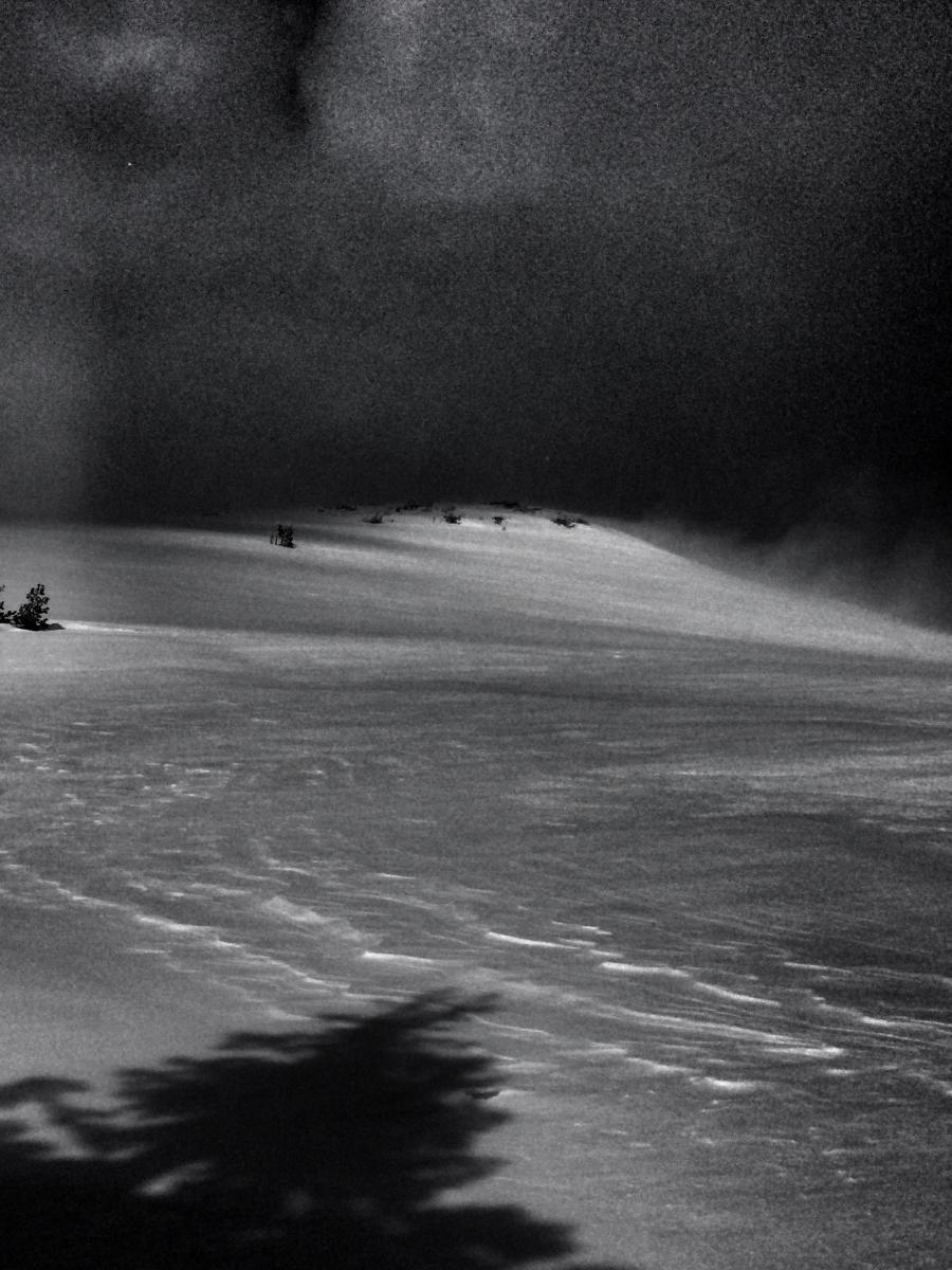
Treeline, Green Butte Ridge, approximately 8,000 feet, Mt Shasta on 4.15.16 - Photo: J Koster
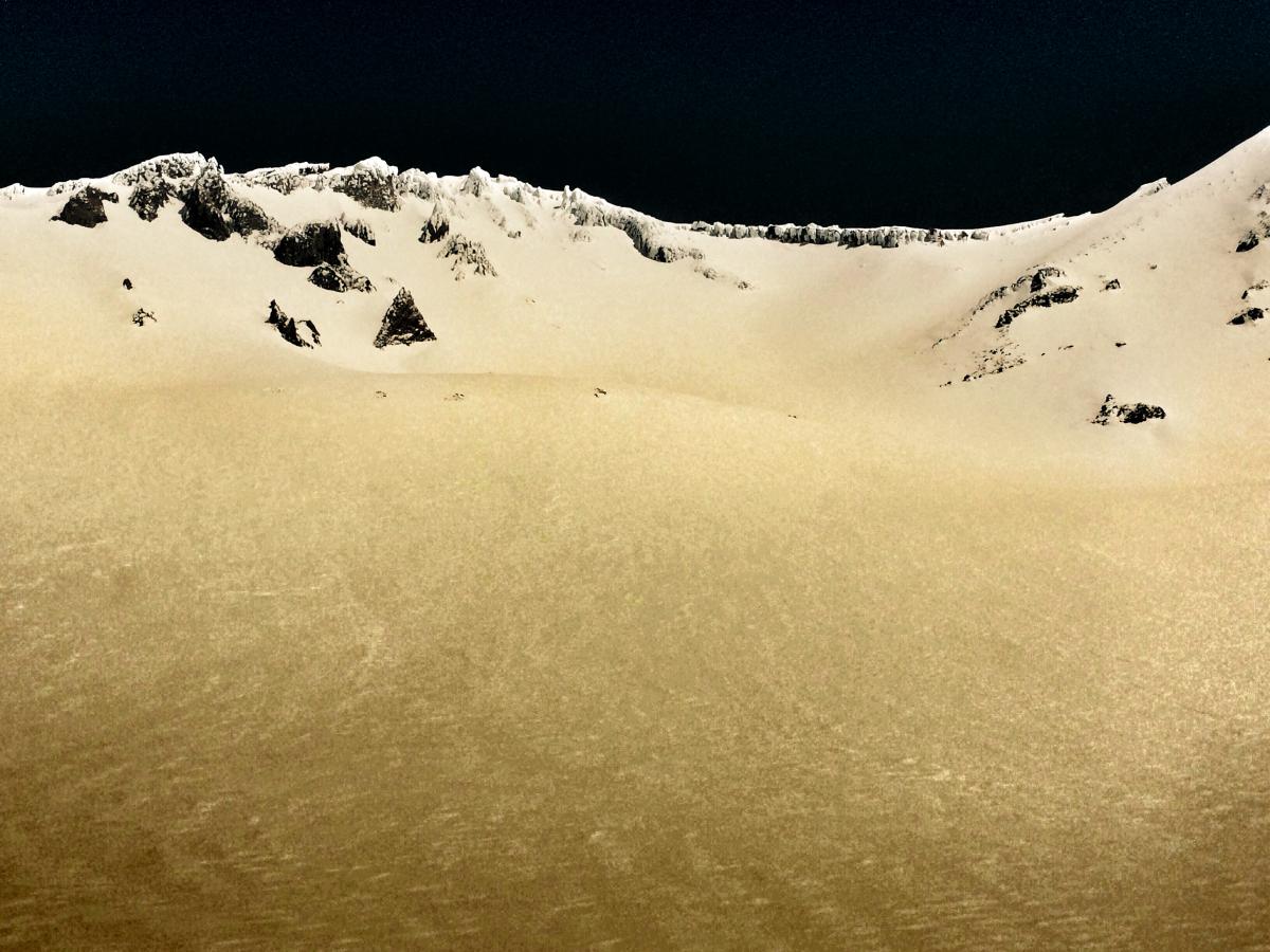
Photo taken just below Lake Helen in Avalanche Gulch on 4.13.16 - Photo: C Carr / Shasta Mtn Guides
Climbing Conditions: Current climbing conditions are good to great. Below are some things to think about when planning your trip this Spring:
- Avalanche Danger & Weather: You may encounter a variety of snow conditions during the spring time. Late season storms can bring fresh snow and high winds to the mountains. Avalanche danger can quickly spike due to new wind and storm slabs on top of icy, firm melt/freeze snow. Further, warm and sometimes downright hot days can create loose wet avalanches. Low danger in the cool morning hours may rise rapidly to higher danger during the afternoon hours on sunny aspects. These are two different avalanche problems associated with different weather patterns with both being possible during the same week, or even the same day. A beacon, shovel and probe continue to be essential, even during Spring time. Always check the avalanche advisory before starting your climb, and call the ranger station for the latest in weather and conditions. Spring time weather patterns can bring it all. The point is... you need to bring the appropriate attire to accommodate all weather conditions. Snow, rain, sun, wind... you can count on all of it on Shasta at some point during Spring time. Further, Mt Shasta can often host a cloud cap creating poor visibility conditions. DO NO climb into a white-out. It is very easy to wander off the WRONG side of Mt Shasta when on the upper mountain, >12,500 feet. This can create a long day and perhaps night for climber, party members, rescue resources and family. Play it safe.
- Firm and smooth snow (slide for life conditions): Snow conditions on Mount Shasta are great right now. That being said, the snow in the morning hours is very firm and very smooth. These types of conditions have caused serious injury in the past to those who slip, trip, or fall and fail to self-arrest as they slide. You MUST know how to self-arrest with an ice axe. This is one of your best defenses for a safe trip on Mt Shasta. Practice this and other climbing skills on small, short slopes in soft snow. If you fall, you must immediately self-arrest or you will take a long, sliding, tumbling fall resulting in serious injury or death. Along with your solid ice axe skills, know how to walk/climb with crampons on. It is easy to catch the front points of the crampon on the cuff of your pant leg resulting in a fall if you are not careful with each step.
- Rime Ice: What is rime ice? Rime ice forms on rocks, towers, etc. as super cooled water droplets freeze upon contact with a solid object. The ice grows into the wind taking on a cauliflower like appearance. The exposed rocks on Mt Shasta at higher elevations are currently plastered in rime ice. This hazard will diminish as the ice flakes off on warm days, but until then... HEADS UP! You absolutely should wear a helmet if climbing. As the days warm, chances increase of getting hit by falling ice until all of it falls off.
-----------------------------------------------------------------------------------------------------------------------------------------------------------
LOCAL AREA ROAD, NORDIC, AND SNOWMOBILE PARK STATUS:
The Sand Flat cross country ski trails are still covered in snow. A little bit of fresh snow has them in better shape currently, though they have been a little crusty before this last storm. These are backcountry routes marked with blue diamonds on trees. Trails are not groomed. Snow shoers, please blaze a parallel trail to cross country skiers staying out of the skin track. These trails can be accessed via the Everett Memorial Highway. Thank you, and enjoy!
The Mt. Shasta Nordic Center is CLOSED for the season. http://www.mtshastanordic.org
The Pilgrim Creek & Deer Mountain Snowmobile Parks are open, however there is currently no snow at these locations. One had to drive down the 19 road (Military Pass) to get to consistent snow before unloading. Head to our "Education" tab on our website and find the snowmobile section for trail information, grooming status, and other sledder resources.
The Castle Lake Road is OPEN. The Everett Memorial Highway is OPEN. The Castle Lake and Everett Hwy are plowed year round to the trailheads. The roads are not always first priority, so your dawn patrol powder mission might be ceased if the plow has not made it up yet. Siskiyou County does a great job keeping the roads clear. Be respectful of the plow drivers if you encounter them. If you get to Bunny Flat before or during when the plow is there, please park on the uphill, LEFT side of the parking lot as you drive in. This is uphill and lookers right of the bathrooms. Thank You!
The Five Red Flags of Avalanche Danger any time of year include: 1) Recent/current avalanche activity 2) Whumphing sounds or shooting cracks 3) Recent/current heavy snowfall 4) Strong winds transporting snow 5) Rapid warming or rain on snow.
Weather and Current Conditions
Weather Summary
Good Morning! In Mt Shasta City at 0500, we have a current temperature of 37 F, 3 degrees warmer than yesterday at this time. Skies are mostly clear with calm wind.
On Mt Shasta (South Side) in the last 24 hours...
Old Ski Bowl - 7,600 feet, the current temperature is 19 degrees F. Snow on the ground totals 128 inches with 1-2 inches of new snow and little settlement. Temperatures have ranged from 18 F to 27 F.
Gray Butte - 8,000 feet, the current temperature is 19 degrees F. Temperatures have ranged from 17 F to 26 F. Wind speeds are not available for Gray Butte at this time. The anemometer was taken down due to the need for repairs. Thank you for your understanding.
Mt Eddy Range (West side of Interstate-5)...
Castle Lake - 5,600 feet, the current temperature is 26 degrees F. Temperatures have ranged from 24 F to 45 F. Snow on the ground totals 45 inches with 1 inch of new snow and little settlement.
Mt Eddy - 6,500 feet, the current temperature is 23 degrees F. Temperatures have ranged from 22 F to 33 F. Snow on the ground measures 57 inches with 1 inch of new snow and little settlement. Winds have been southeast in nature with an average of 3 mph, and a maximum gust of 12 mph, SE.
Always check the weather before you attempt to climb Mt Shasta. Further, monitor the weather as you climb. Becoming caught on the mountain in any type of weather can compromise life and limb. Be prepared.
| 0600 temperature: | 21 |
| Max. temperature in the last 24 hours: | 33 |
| Average wind direction during the last 24 hours: | N/A |
| Average wind speed during the last 24 hours: | N/A mi/hr |
| Maximum wind gust in the last 24 hours: | N/A mi/hr |
| New snowfall in the last 24 hours: | .5-1 inches |
| Total snow depth: | 72 inches |
Two Day Mountain Weather Forecast
Produced in partnership with the Medford NWS
| For 7000 ft to 9000 ft | |||
|---|---|---|---|
|
Friday (4 a.m. to 10 p.m.) |
Friday Night (10 p.m. to 4 a.m.) |
Saturday (4 a.m. to 10 p.m.) |
|
| Weather | Mostly sunny | Mostly clear | Sunny |
| Temperature (°F) | 43 | 32 | 55 |
| Wind (mi/hr) | North 10-15 mph | Northeast 5-10 mph | North 5-10 mph |
| Precipitation SWE / Snowfall (in) | / 0 | / 0 | / 0 |
| For 9000 ft to 11000 ft | |||
| Friday | Friday Night | Saturday | |
| Weather | Mostly sunny. Windy. Wind chill values as low as -13. | Mostly clear, temperatures rising. Windy. | Sunny. Windy. |
| Temperature (°F) | 25 | 28 | 35 |
| Wind (mi/hr) | North 40-50 mph | North/Northwest 0 | North 20-30 mph, decreasing |
| Precipitation SWE / Snowfall (in) | / 0 | / 0 | / 0 |

