

You are here
Avalanche Advisory for 2016-12-03 06:20:12
- EXPIRED ON December 4, 2016 @ 6:20 amPublished on December 3, 2016 @ 6:20 am
- Issued by Nick Meyers - Shasta-Trinity National Forest
Bottom Line
Today, LOW avalanche danger will preside over the forecast area. Normal caution is advised for backcountry travel. Always be on the watch for unstable snow on isolated terrain features. Smooth, firm and wind scoured snow exists above treeline on Mt Shasta. A slip and fall on a steep slope could result in a slide for life without proper ice axe, crampon and self arrest skills. Be prepared and know how to use the equipment properly.


Avalanche Problem 1: Normal Caution
-
Character ?

-
Aspect/Elevation ?
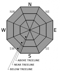
-
Likelihood ?CertainVery LikelyLikelyPossible
 Unlikely
 -
Size ?HistoricVery LargeLargeSmall

What does 'normal caution' mean? Normal caution means using proper backcountry travel protocols every time you head out to ski, board or ride. Always be sure to conduct beacon checks, communicate with your group about the days travel plan and take stock of each group members stengths and potential weaknesses. Be able to identify areas of potentially unstable snow and safe and/or unsafe terrain choices. Expose only one member of your group to avalanche terrain at a time. Have a plan! Voice your opinions, don't take things personally, take a humble attitude toward Mother Nature. Because no matter how many times you've skied that slope, no matter how much knowledge and experience you have, no matter how local you are, an avalanche does not care.
Forecast Discussion
The forecast area has not received any new snow over the week and temperatures have trended on the cooler side. The snowpack on Mt Shasta is robust and wind affected near and above treeline. Firm, wind sculpted snow with scoured ridgelines and likely some very smooth and firm areas in the alpine will greet any mid and upper elevation skiers, riders or climbers. While the avalanche danger is low, having self arrest skills is a more notable concern for conditions as such. Whenever we see firm and smooth conditions like we have at mid/upper mountain elevations, self arrest skills are mandatory should one slip and fall on steeper slopes. Carry an ice axe and crampons and know how to use them. A helmet is always a good idea also to precent injury from falling rime ice and perhaps the occasional rock.
Recent Observations
No new observations have been made or have come in from the forecast area in the last 24 hours. With our clear and cold weather, the snow and avalanche conditions have remained static. That is, variable snow, firm and wind scoured above treeline and breakable crust with the occasional soft snow in protected, shady areas below treeline. Near treeline, expect all of the above. Castle Lake and the Mt Eddy ranges continue to have a fairly shallow snowpack. That should hopefully change soon with winter rolling in this month.
We've had a 20 degree warming trend over the last 24 hours, reported from the Old Ski Bowl and Gray Butte weather stations on Mt Shasta. While this is a pretty rapid warming trend, the firm, hard and wind scoured nature of the snow on the mountain has likely not reacted much to this increase in temperature. Further, the temps will begin to fall drastically as the weekend progresses. The Old Ski Bowl weather station also reported .81 inches of water overnight. With the above freezing temperatures, this fell as rain. Upper elevations may have received some snow, however winds kicked up considerably last night blowing 35-45 mph out of the northwest with a max gust of 71 mph. Any new snow likely sublimated off the mountain. West of I-5, a 10 degree warm-up has occurred in the last 24 hours, with little precipitation.
================================================================================
LOCAL AREA ROAD, NORDIC, AND SNOWMOBILE PARK STATUS:
The Sand Flat cross country ski trails are in good shape still and ready for your cross country skis and snow shoes. These are backcountry routes marked with blue diamonds on trees. Trails are not groomed. Snow shoers, please blaze a parallel trail to cross country skiers staying out of the skin track. These trails can be accessed via the Everett Memorial Highway. Thank you, and enjoy!
The Mt. Shasta Nordic Center is CLOSED for the time being but will be opening soon! The trails are covered in snow and they are working on getting things going this month. http://www.mtshastanordic.org
The Pilgrim Creek & Deer Mountain Snowmobile Parks are open, however there is no snow at these locations currently. One must drive down the 19 road (Military Pass) for an unknown distance to get to consistent snow before unloading. Head to our "Education" tab on our website and find the snowmobile section for trail information, grooming status, and other sledder resources.
The Castle Lake Road is OPEN. The Everett Memorial Highway is OPEN. The Castle Lake and Everett Hwy are plowed year round to the trailheads. The roads are not always first priority, so your dawn patrol powder mission might be ceased if the plow has not made it up yet. Siskiyou County does a great job keeping the roads clear. Be respectful of the plow drivers if you encounter them. If you get to Bunny Flat before or during when the plow is there, please park on the uphill, LEFT side of the parking lot as you drive in. This is uphill and lookers right of the bathrooms. Thank You!
The Five Red Flags of Avalanche Danger any time of year include: 1) Recent/current avalanche activity 2) Whumphing sounds or shooting cracks 3) Recent/current heavy snowfall 4) Strong winds transporting snow 5) Rapid warming or rain on snow.
Weather and Current Conditions
Weather Summary
A weak cold front moves over the northern part of the forecast area with mostly sunny skies in store today, with perhaps a few clouds beginning to move in later in the day as an approaching, much stronger cold front drops in from the north. Snow levels will fall drastically on Sunday night as cold air pushes in and a bit of precipitation arrives. Expect snow levels around 1000 feet by Monday morning with a few inches of snow possible here in Mt Shasta. Tuesday should be the coldest day of the year thus far. A short break in the cold, dry weather will ensue Wednesday, followed by a warming trend and more precip for later in the week. Stay tuned!
================================
In Mt Shasta City at 0500, we have a current temperature of 34 F.
On Mt Shasta (South Side) in the last 24 hours...
Old Ski Bowl - 7,600 feet, the current temperature is 46 degrees F. Snow on the ground totals 43 inches with with .81 inches precipitation overnight and 1 inch settlement. Temperatures have ranged from 23 F to 46F.
Gray Butte - 8,000 feet, the current temperature is 42 degrees F. Temperatures have ranged from 23 F to 44 F. Winds have been light and variable, 5-10 mph until about 1700 when winds out of the NW picked up and have averaged 35-45 mph, NW, with a max gust to 71 mph.
Mt Eddy Range (West side of Interstate-5)...
Castle Lake - 5,600 feet, the current temperature is 31 degrees F. Temperatures have ranged from 20 F to 32 F. Snow on the ground totals 16 inches with no new snow and one inch settlement.
Mt Eddy - 6,500 feet, the current temperature is 31 degrees F. Temperatures have ranged from 21 F to 37 F. Snow on the ground measures 19 inches with no new snow and 2 inches settlement. Winds have been southeast in nature with an average of 2-4 mph, and a maximum gust of 17 mph, SE.
THIS SEASON PRECIPITATION for MT SHASTA CITY: Since October 1st (the wet season), we have received 16.47 inches of water, normal is 7.80 inches, putting us at 210% of normal. For the month of December we received 0.0 inches of water, normal is .45 inches, putting us at 0% of normal, and finally... for the year of 2016 we've received 49.37 inches of water, normal is 35.81 inches, putting us at 137% of normal.
Always check the weather before you attempt to climb Mt Shasta. Further, monitor the weather as you climb. Becoming caught on the mountain in any type of weather can compromise life and limb. Be prepared.
| 0600 temperature: | 38 |
| Max. temperature in the last 24 hours: | 38 |
| Average wind direction during the last 24 hours: | Northwest |
| Average wind speed during the last 24 hours: | 5-10 mi/hr |
| Maximum wind gust in the last 24 hours: | 15-20 mi/hr |
| New snowfall in the last 24 hours: | 0 inches |
| Total snow depth: | 25 inches |
Two Day Mountain Weather Forecast
Produced in partnership with the Medford NWS
| For 7000 ft to 9000 ft | |||
|---|---|---|---|
|
Saturday (4 a.m. to 10 p.m.) |
Saturday Night (10 p.m. to 4 a.m.) |
Sunday (4 a.m. to 10 p.m.) |
|
| Weather | Mostly sunny | Partly cloudy | Rain and snow likely, mainly after 4pm. Mostly cloudy. Chance of precipitation is 60%. |
| Temperature (°F) | 40 | 32 | 40, falling to 32 |
| Wind (mi/hr) | North/Northeast 10-15 mph with gusts to 30 mph | North 5-10 mph with gusts to 20 mph | West/Northwest, becoming southwest in the afternoon. 15-20 mph, gusts to 30 mph |
| Precipitation SWE / Snowfall (in) | / 0 | / 0 | / 0-.5 |
| For 9000 ft to 11000 ft | |||
| Saturday | Saturday Night | Sunday | |
| Weather | Mostly sunny, windy. | Partly cloudy. Windy. | A slight chance of snow showers before 10am, then a chance of snow between 10am and 4pm, then snow showers likely after 4pm. Mostly cloudy. Windy. |
| Temperature (°F) | 31 | 25 | 22 |
| Wind (mi/hr) | Northwest 20-30 mph, increasing to 30-40 in afternoon. Gusts could be higher. | West/Northwest 0 | West 50-60 mph with gusts 70-80 mph |
| Precipitation SWE / Snowfall (in) | / 0 | / 0 | / 0-1 |

