

You are here
Avalanche Advisory for 2016-12-12 06:54:40
- EXPIRED ON December 13, 2016 @ 6:54 amPublished on December 12, 2016 @ 6:54 am
- Issued by Andrew Kiefer - Mt Shasta Avalanche Center
Bottom Line
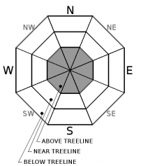
Strong west/northwest winds have blown on Mt Shasta over the past four days. MODERATE avalanche danger exists above treeline while the danger is LOW near and below treeline. The primary avalanche concern for today is the wind slab problem. Human triggered avalanches are possible, and the areas most suspect are slopes steeper than 35 degrees on N-NE-E-SE-S aspects above treeline. Natural avalanches are unlikely. Many slopes are scoured and icy making a slide for life possible as well.


Avalanche Problem 1: Wind Slab
-
Character ?

-
Aspect/Elevation ?
-
Likelihood ?CertainVery LikelyLikelyPossible
 Unlikely
 -
Size ?HistoricVery LargeLargeSmall

It remains possible for backcountry travelers to trigger wind slab avalanches 1-2ft deep above treeline today. Steady northwest winds with strong to extreme gusts have blown for the past 4 days. All this wind has redistributed the snow from last week unevenly throughout the terrain. In many places near and above treeline, the snow is scoured down to a firm and icy bed surface and hard, wind sculpted snow features are difficult to avoid. Despite this, there is still snow available for transport above treeline and wind slab development continues.
Natural wind slab avalanches are unlikely. Human triggered avalanches are possible on specific terrain features steeper than 35 degrees like convex roll overs, unsupported slopes near and above cliff bands, slopes below ridgelines, rock outcrops, and narrow gullies. Northwest winds have been predominantly loading east and south facing slopes, but winds have also funneled through and around terrain features and the potential for wind slabs exists on all aspects above treeline. These wind slabs are likely difficult to trigger, but a wind slab avalanche of this nature would have serious consequences given how firm the snow surface is and how hard the slab would be.
Forecast Discussion
The forecast area is now at least three days out from the most recent avalanche activity that occurred during the storms last week. Evidence of natural wind slab activity was visible over the weekend as the skies cleared and the mountain slopes were revealed. These avalanches ran in upper elevation terrain where the precipitation totals were greatest and where the winds were most intense.
While human triggered avalanches remain possible today, it is good to remember the best tools for identifying the wind slab problem are visual observations. Look for evidence of wind transported snow – drifts, plumes, cornice growth, and wind effect on the snow surface. Identify the specific terrain features where loading has occurred and where the wind slab problem may exist, and avoid those areas if they are steeper than 35 degrees.
Variable snow surface conditions currently exist in the backcountry. Breakable crust is widespread near and below treeline. Firm and icy conditions prevail on steep slopes above treeline and will likely warrant the use of an ice axe and crampons. Use caution in areas of loaded snow as these are the locations where the skiing and riding may be best and also where avalanches are most likely today.
===============================================================
LOCAL AREA ROAD, NORDIC, AND SNOWMOBILE PARK STATUS:
The Sand Flat cross country ski trails are in good shape still and ready for your cross country skis and snow shoes. These are backcountry routes marked with blue diamonds on trees. Trails are not groomed. Snow shoers, please blaze a parallel trail to cross country skiers staying out of the skin track. These trails can be accessed via the Everett Memorial Highway. Thank you, and enjoy!
The Mt. Shasta Nordic Center is CLOSED for the time being but will be opening soon! The trails are covered in snow and they are working on getting things going this month. http://www.mtshastanordic.org
The Pilgrim Creek & Deer Mountain Snowmobile Parks are open, however there is no snow at these locations currently. One must drive down the 19 road (Military Pass) for several miles to get to consistent snow before unloading. Private industry is logging out there so watch out for log trucks. Head to our "Education" tab on our website and find the snowmobile section for trail information, grooming status, and other sledder resources.
The Castle Lake Road is OPEN. The Everett Memorial Highway is OPEN. The Castle Lake and Everett Hwy are plowed year round to the trailheads. The roads are not always first priority, so your dawn patrol powder mission might be ceased if the plow has not made it up yet. Siskiyou County does a great job keeping the roads clear. Be respectful of the plow drivers if you encounter them. If you get to Bunny Flat before or during when the plow is there, please park on the uphill, LEFT side of the parking lot as you drive in. This is uphill and lookers right of the bathrooms. Thank You!
The Five Red Flags of Avalanche Danger any time of year include: 1) Recent/current avalanche activity 2) Whumphing sounds or shooting cracks 3) Recent/current heavy snowfall 4) Strong winds transporting snow 5) Rapid warming or rain on snow.
Recent Observations
Northwest winds averaging 15-25mph and gusting to 40-50mph have been steady over the past 4 days. There is certainly no shortage of evidence of the effect these strong winds have had on the snowpack. Plumes of snow billowing off ridge tops and across terrain features were visible all throughout the day yesterday. The most noticeable evidence of wind has been scouring of windward slopes and exposed terrain features above treeline. Firm, icy, and wind sculpted snow surfaces were observed yesterday during a snowmobile tour in the Old Ski Bowl. Despite the many firm snow surfaces, there continues to be snow available for transport above treeline, and continued snowpack loading on leeward slopes was observed. Near and below treeline, rain crusts have capped the snow surface up to the 7,800-8,000ft levels, limiting the amount of snow available for transport. Evidence of the natural wind slab avalanche activity that occured during the storm series last week was confined to convexities and unsupported slopes steeper than 35 degrees in upper elevation terrain.
================================================================================
Have you seen our new, BIG BLUE buttons on our website? Yep, thats them, just up and to your left! You can use those and absolutely should. No more email, no more text, no more messing around! So cool. Please submit your observations by clicking either 'snowpack' or 'avalanche' observation and follow the template. Just a photo? Great! Snowpit profile? Awesome! Video, notes, weather...you name it, there is a place for it. It's simple, easy and fun and extremely useful for us and other users. We also have a drop down menu within the obs template that allows you to submit observations from "out of the forecast area". Heading to Crater Lake or Mt Lassen? Submit some obs! This will help us create the BEST possible avalanche advisory AND provide a great place for peeps to go for checking backcountry conditions. Saddle up!
Weather and Current Conditions
Weather Summary
A weak, upper level ridge of high pressure will move through the area today. Expect windy conditions with clear and mostly sunny skies and temperatures reaching highs in the low 30's. Strong winds will blow out of the northwest before shifting to the south later in the day. Wind speeds will average 15-20mph with gusts in the 30mph range. In upper elevation terrain, winds are forecast to be much higher in the 30-40mph with gusts 60-70mph bringing wind chill values down to the single digits. An unsettled weather pattern is scheduled to move into the forecast area tomorrow night and continue throughout the week. Wednesday and Thursday look to bring a good dose of precipitation.
================================
In Mt Shasta City at 0400, we have a current temperature of 23 F with clear skys.
On Mt Shasta (South Side) in the last 24 hours...
Old Ski Bowl - 7,600 feet, the current temperature is 23 degrees F. Snow on the ground totals 52 inches with no new snow and .5 inches of settlement. Temperatures have ranged from 14F to 26F.
Gray Butte - 8,000 feet, the current temperature is 18 degrees F. Temperatures have ranged from 13 F to 24 F. Winds have averaged 15-25 mph out of the west/northwest with gusts to 30 mph.
Mt Eddy Range (West side of Interstate-5)...
Castle Lake - 5,600 feet, the current temperature is 22 degrees F. Temperatures have ranged from 21 F to 34 F. Snow on the ground totals 17 inches with no new snow and 1 inch of settlement.
Mt Eddy - 6,500 feet, the current temperature is 19 degrees F. Temperatures have ranged from 15 F to 29 F. Snow on the ground measures 22 inches with no new snow and little settlement. Winds have averaged 1-4 mph out of the southwest with gusts to 7 mph.
THIS SEASON PRECIPITATION for MT SHASTA CITY: Since October 1st (the wet season), we have received 17.50 inches of water, normal is 9.93 inches, putting us at 176% of normal. For the month of December we received 1.03 inches of water, normal is 2.57 inches, putting us at 40% of normal, and finally... for the year of 2016 we've received 50.40 inches of water, normal is 37.93 inches, putting us at 133% of normal.
Always check the weather before you attempt to climb Mt Shasta. Further, monitor the weather as you climb. Becoming caught on the mountain in any type of weather can compromise life and limb. Be prepared.
| 0600 temperature: | 17 |
| Max. temperature in the last 24 hours: | 28 |
| Average wind direction during the last 24 hours: | West/Northwest |
| Average wind speed during the last 24 hours: | 15-25 mi/hr |
| Maximum wind gust in the last 24 hours: | 30 mi/hr |
| New snowfall in the last 24 hours: | 0 inches |
| Total snow depth: | 29 inches |
Two Day Mountain Weather Forecast
Produced in partnership with the Medford NWS
| For 7000 ft to 9000 ft | |||
|---|---|---|---|
|
Monday (4 a.m. to 10 p.m.) |
Monday Night (10 p.m. to 4 a.m.) |
Tuesday (4 a.m. to 10 p.m.) |
|
| Weather | Mostly sunny | Mostly cloudy, then a slight chance of snow showers | A 30 percent chance of snow showers mainly after 10am |
| Temperature (°F) | 32 | 21 | 30 |
| Wind (mi/hr) | Northwest, becoming southeast 15-20 mph | South 15-20 mph | South 15-20 mph |
| Precipitation SWE / Snowfall (in) | / 0 | / 0 | / 1 |
| For 9000 ft to 11000 ft | |||
| Monday | Monday Night | Tuesday | |
| Weather | Mostly sunny and windy | Mostly cloudy and windy, then slight chance of snow showers | Chance of snow showers and windy |
| Temperature (°F) | 19 | 18 | 21 |
| Wind (mi/hr) | West 60-65 mph decreasing to 50-55 mph in the afternoon, gusts 70+mph | West/southwest 0 | West 55-65 mph with gusts 70+ |
| Precipitation SWE / Snowfall (in) | / 0 | / trace | / 1-2 |

