

You are here
Avalanche Advisory for 2016-12-20 06:52:14
- EXPIRED ON December 21, 2016 @ 6:52 amPublished on December 20, 2016 @ 6:52 am
- Issued by Andrew Kiefer - Mt Shasta Avalanche Center
Bottom Line
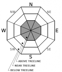
MODERATE avalanche danger exists on all aspects above treeline. Steady, westerly winds continue to transport snow making wind slabs the primary avalanche problem. Natural avalanches are unlikely, and human triggered avalanches remain possible. Evaluate snow and terrain carefully, and identify features of concern. LOW avalanche danger exists near and below treeline.


Avalanche Problem 1: Wind Slab
-
Character ?

-
Aspect/Elevation ?
-
Likelihood ?CertainVery LikelyLikelyPossible
 Unlikely
 -
Size ?HistoricVery LargeLargeSmall

Transport of snow, and wind slab development can occur for several days following the end of a storm. This is currently the case within our advisory area above treeline and in upper elevation terrain. Variable winds have blown and redistributed snow, loading leeward slopes and cross loading alpine terrain features.
Look for smooth and rounded pillows of snow, active wind transport, and cornice formations. Sometimes, these areas of wind loaded snow sound hollow. Avoid leeward slopes steeper than 35 degrees where a transition from hard, scoured snow to softer snow exists. Wind slabs may be encountered on all aspects above treeline, but westerly winds have made SE, E, and NE aspects most suspect. Stick to sheltered, or wind scoured areas if you plan to venture high into the alpine today.
Forecast Discussion
Below treeline, non-freezing temperatures for the past 24 hours, and the possibility of rain on snow will likely make for unconsolidated and damp snow surfaces. Near treeline marks the transition to freezing levels. In these elevations, backcountry travelers will likely encounter a great deal of snow surface variability.
The greatest avalanche concern for today is confined to leeward slopes and cross-loaded terrain features above treeline. These are the specific areas where the wind slab problem exists. Natural avalanches are unlikely, but human triggered avalanches remain possible. Backcountry travelers should evaluate snow and terrain carefully.
==============================================================
LOCAL AREA ROAD, NORDIC, AND SNOWMOBILE PARK STATUS:
The Sand Flat cross country ski trails are in good shape still and ready for your cross country skis and snow shoes. These are backcountry routes marked with blue diamonds on trees. Trails are not groomed. Snow shoers, please blaze a parallel trail to cross country skiers staying out of the skin track. These trails can be accessed via the Everett Memorial Highway. Thank you, and enjoy!
The Mt. Shasta Nordic Center is CLOSED for the time being but will be opening soon! The trails are covered in snow and they are working on getting things going this month. http://www.mtshastanordic.org
The Pilgrim Creek & Deer Mountain Snowmobile Parks are open, however there is no snow at these locations currently. One must drive down the 19 road (Military Pass) for several miles to get to consistent snow before unloading. Private industry is logging out there so watch out for log trucks. Head to our "Education" tab on our website and find the snowmobile section for trail information, grooming status, and other sledder resources.
The Castle Lake Road is OPEN. The Everett Memorial Highway is OPEN. The Castle Lake and Everett Hwy are plowed year round to the trailheads. The roads are not always first priority, so your dawn patrol powder mission might be ceased if the plow has not made it up yet. Siskiyou County does a great job keeping the roads clear. Be respectful of the plow drivers if you encounter them. If you get to Bunny Flat before or during when the plow is there, please park on the uphill, LEFT side of the parking lot as you drive in. This is uphill and lookers right of the bathrooms. Thank You!
The Five Red Flags of Avalanche Danger any time of year include: 1) Recent/current avalanche activity 2) Whumphing sounds or shooting cracks 3) Recent/current heavy snowfall 4) Strong winds transporting snow 5) Rapid warming or rain on snow.
Recent Observations
Yesterday, NW winds blew steady averaging 10-20mph with gusts 25-35mph, and 40-50mph gusts in higher elevations. Temperatures stayed above freezing throughout the day. Non-freezing temperatures continued overnight at all of our remote weather stations. A weak temperature inversion remained in place for the past 24 hours between town and roughly the 8000ft level.
Areas of wind-loaded snow were recently observed throughout upper elevation terrain on Mount Shasta. Easterly aspects were especially subject to wind loading due to steady westerly winds. Following the end of our most recent storm, continuous blowing of snow above treeline has occurred. Variable snow conditions exist throughout the advisory area. Scoured surfaces, wind sculpted snow features, firm and icy slopes, and chalky powder may be encountered in upper elevation terrain. No recent reports of instability have been observed below or near treeline.
===============================================================================
Have you seen our new, BIG BLUE buttons on our website? Yep, thats them, just up and to your left! You can use those and absolutely should. No more email, no more text, no more messing around! So cool. Please submit your observations by clicking either 'snowpack' or 'avalanche' observation and follow the template. Just a photo? Great! Snowpit profile? Awesome! Video, notes, weather...you name it, there is a place for it. It's simple, easy and fun and extremely useful for us and other users. We also have a drop down menu within the obs template that allows you to submit observations from "out of the forecast area". Heading to Crater Lake or Mt Lassen? Submit some obs! This will help us create the BEST possible avalanche advisory AND provide a great place for peeps to go for checking backcountry conditions. Saddle up!
Weather and Current Conditions
Weather Summary
A weak temperature inversion between town level and 8000ft continues this morning. Forecast models have trended slower and weaker with precipitation, allowing for cloudy skies and a 40-50 percent chance of rain and snow for the first half of the day. High temperatures will be near 40 degrees with freezing levels expected to be 7500-8000ft. 1-2 inches of snow may accumulate in upper elevations by early afternoon, but confidence in the weather models is low Winds are expected to blow out of the southwest averaging 5-10mph with gusts to 20mph. Winds will ramp up, and shift to the northwest with gusts around 30mph later in the day. Upper elevations will likely see gusts up to 40-50mph. Any chance for precipitation will taper off by early afternoon. High pressure will then move into the area bringing cooler temperatures tonight. Dry weather is expected on Wednesday.
==============================
In Mt Shasta City at 0500, we have a current temperature of 31 F.
On Mt Shasta (South Side) in the last 24 hours...
Old Ski Bowl - 7,600 feet, the current temperature is 38F degrees F. Snow on the ground totals 69 inches with 2 inches of settlement. Temperatures have ranged from 30F to 40F.
Grey Butte - 8,000 feet, the current temperature is 38 degrees F. Temperatures have ranged from 32F to 38 F. Winds blew out of the NW and have averaged 15-20 mph, with gusts as high as 40mph.
Mt Eddy Range (West side of Interstate-5)...
Castle Lake - 5,600 feet, the current temperature is 40 degrees F. Temperatures have ranged from 33 F to 43 F. Snow on the ground totals 17 inches with little settlement.
Mt Eddy - 6,500 feet, the current temperature is 39 degrees F. Temperatures have ranged from 30 F to 42 F. Snow on the ground measures 25 inches with no new settlement. Winds have averaged 1-3 mph with gusts to 10 mph, out of the WSW.
THIS SEASON PRECIPITATION for MT SHASTA CITY: Since October 1st (the wet season), we have received 20.25 inches of water, normal is 12.04 inches, putting us at 167% of normal. For the month of December we received 3.78 inches of water, normal is 4.68 inches, putting us at 81% of normal, and finally... for the year of 2016 we've received 53.15 inches of water, normal is 40.04 inches, putting us at 133% of normal.
Always check the weather before you attempt to climb Mt Shasta. Further, monitor the weather as you climb. Becoming caught on the mountain in any type of weather can compromise life and limb. Be prepared.
| 0600 temperature: | 35 |
| Max. temperature in the last 24 hours: | 43 |
| Average wind direction during the last 24 hours: | NW |
| Average wind speed during the last 24 hours: | 15-20 mi/hr |
| Maximum wind gust in the last 24 hours: | 40 mi/hr |
| New snowfall in the last 24 hours: | 0 inches |
| Total snow depth: | 33 inches |
Two Day Mountain Weather Forecast
Produced in partnership with the Medford NWS
| For 7000 ft to 9000 ft | |||
|---|---|---|---|
|
Tuesday (4 a.m. to 10 p.m.) |
Tuesday Night (10 p.m. to 4 a.m.) |
Wednesday (4 a.m. to 10 p.m.) |
|
| Weather | Rain/Freezing Rain Likely | Mostly Clear | Sunny |
| Temperature (°F) | 38 | 22 | 39 |
| Wind (mi/hr) | Southwest shifting to Northwest 15-20mph | Northeast 10-15mph | East/Southeast 10-15 mph |
| Precipitation SWE / Snowfall (in) | / 0 | / 0 | / 0 |
| For 9000 ft to 11000 ft | |||
| Tuesday | Tuesday Night | Wednesday | |
| Weather | Windy. Chance Wintery Mix, then Chance Snow. | Mostly Clear and Blustery | Sunny and Blustery |
| Temperature (°F) | 27 | 21 | 25 |
| Wind (mi/hr) | West, Northwest 40-50 mph | North 1-3 | North/Northeast 20-30mph |
| Precipitation SWE / Snowfall (in) | / 1-3 | / 0 | / 0 |

