

You are here
Avalanche Advisory for 2016-12-24 07:10:50
- EXPIRED ON December 25, 2016 @ 7:10 amPublished on December 24, 2016 @ 7:10 am
- Issued by Andrew Kiefer - Mt Shasta Avalanche Center
Bottom Line
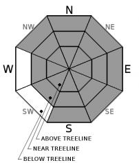
The avalanche danger is CONSIDERABLE above treeline and near treeline. MODERATE danger exists below treeline today. Wind slabs are most suspect on NW-N-NE-E-SE-S slopes in upper elevation terrain, but may be found on all aspects due to strong and variable winds. Up to a foot of new snow has fallen recently, and the storm slab problem is a concern for today as well.


Avalanche Problem 1: Wind Slab
-
Character ?

-
Aspect/Elevation ?
-
Likelihood ?CertainVery LikelyLikelyPossible
 Unlikely
 -
Size ?HistoricVery LargeLargeSmall

Wind slabs are the primary concern for today. The potential for the wind slab problem exists at all elevations bands, but is most significant near and above treeline. Leeward NW-N-NE-E-SE slopes are most suspect. Due to variable wind directions however, all aspects near above treeline could pose a threat and hold deposits of wind-loaded snow. Wind slabs thickness is expected to be 2-4ft. Today, look for active wind transport of snow and pay attention to wind direction. Identify lee slopes and cross-loaded terrain features 35 degrees and steeper. Stick to wind sheltered areas, scoured slopes, and lower angle terrain to avoid the wind slab problem.
As we saw in the large Casaval Ridge avalanche last week, the newer wind loaded snow stepped down into deeper layers, igniting an old persistent weak layer from early season. While unlikely and difficult to trigger, if new snow loading and perhaps the weight of a skier tipped the stress vs strength scale of an old wind slab, a large and destructive avalanche would be the result. These types of avalanches are hard to predict.
Avalanche Problem 2: Storm Slab
-
Character ?

-
Aspect/Elevation ?
-
Likelihood ?CertainVery LikelyLikelyPossible
Unlikely
-
Size ?HistoricVery LargeLargeSmall
With up to a foot of new snow and .75” SWE (Snow Water Equivalent), the possibility of storm slabs exists at all elevations and on all aspects today. Storm slabs usually take a few hours, to a few days to stabilize. Today, they are most likely to occur on unsupported slopes steeper than 35 degrees. The new snow has fallen on a variety of snow surfaces, including a crust and firm snow. These may provide a productive bed surface for snow to slide. Today, take the time to assess how the new snow is bonding to the old snow surface.
Forecast Discussion
The advisory area received up to a foot of new snow since late Thursday evening. Accompanying this snow were strong and variable winds and cold temperatures. We certainly have snow available for transport, and the wind slab problem is the primary concern. The storm slab problem is also a concern, and how reactive this problem may become is largely dependent on how cohesive the new snow is today. With clearing skies in the forecast and quality skiing conditions present, make sure to prioritize snowpack stability assessment if you venture into the backcountry. It will be easy to be lured into avalanche terrain by sunny skies and powder. Please stay safe this holiday season!
==============================================================
LOCAL AREA ROAD, NORDIC, AND SNOWMOBILE PARK STATUS:
The Sand Flat cross country ski trails are in good shape and ready for your cross country skis and snow shoes. These are backcountry routes marked with blue diamonds on trees. Trails are not groomed. Snow shoers, please blaze a parallel trail to cross country skiers staying out of the skin track. These trails can be accessed via the Everett Memorial Highway. Thank you, and enjoy!
The Mt. Shasta Nordic Center is OPEN for the season! Take advantage of this wonderful venue. Groomed trails accomodate both classic and skate skiing styles. Rentals available. Visit their website for more details. http://www.mtshastanordic.org
The Pilgrim Creek & Deer Mountain Snowmobile Parks are open, however there is no snow at these locations currently. One must drive down the 19 road (Military Pass) for several miles to get to consistent snow before unloading. Private industry is logging out there so watch out for log trucks. Head to our "Education" tab on our website and find the snowmobile section for trail information, grooming status, and other sledder resources.
The Castle Lake Road is OPEN. The Everett Memorial Highway is OPEN. The Castle Lake and Everett Hwy are plowed year round to the trailheads. The roads are not always first priority, so your dawn patrol powder mission might be ceased if the plow has not made it up yet. Siskiyou County does a great job keeping the roads clear. Be respectful of the plow drivers if you encounter them. If you get to Bunny Flat before or during when the plow is there, please park on the uphill, LEFT side of the parking lot as you drive in. This is uphill and lookers right of the bathrooms. Thank You!
The Five Red Flags of Avalanche Danger any time of year include: 1) Recent/current avalanche activity 2) Whumphing sounds or shooting cracks 3) Recent/current heavy snowfall 4) Strong winds transporting snow 5) Rapid warming or rain on snow.
Recent Observations
Precipitation totals throughout the advisory area are 9-12” of snow with up to .75” of SWE (snow water equivalent) above 6,000ft. Winds blew 10-20mph with gusts up to 35mph yesterday and overnight. Wind direction was variable, but mostly blew from the SW. The new snow was cold, light, and unconsolidated in areas protected from the wind. During a tour in Giddy Giddy Gulch yesterday, evidence of blowing snow was observed near and below treeline. In open wind exposed areas, drifted snow measured up to 2ft deep. No avalanches, shooting cracks, or whoomphs were observed. In a test pit conducted yesterday afternoon on a NW slope at 7600ft, planar shears occurred in small column tests within the new storm snow, and at the new snow/old snow interface. No propagation occurred in large column tests. At that time, the storm snow was 6-8" deep, and was just beginning to show slab characteristics.
Weather and Current Conditions
Weather Summary
Northwest flow continues, and a chance of intermittent snowfall is possible through 10am this morning. Snow levels have dropped to 1500ft, and temperatures will remain cold with highs in the low 20’s today. Temperatures in upper elevations will remain in the single digits with wind chill values as low as -20F. Skies are expected to become partly sunny with a clearing trend. Winds will blow out of the Northwest 10-15mph with gusts as high 40-50mph. Overnight lows will drops to the teens and single digits. Christmas Day will be mostly sunny with highs in the mid 20’s.
============================================================
In Mt Shasta City at 0500, we have a current temperature of 30 F, with partly cloudy skies.
On Mt Shasta (South Side) in the last 24 hours...
Old Ski Bowl - 7,600 feet, the current temperature is 14 degrees F. Snow on the ground totals 78 inches with 9 inches of new snow. Temperatures have ranged from 13F to 20F.
Grey Butte - 8,000 feet, the current temperature is 15 degrees F. Temperatures have ranged from 15 F to 20 F. Winds have been variable, mostly blowing out of the SW and NW averaging 15-20 mph, with gusts as high as 35 mph.
Mt Eddy Range (West side of Interstate-5)...
Castle Lake - 5,600 feet, the current temperature is 19 degrees F. Temperatures have ranged from 19 F to 29 F. Snow on the ground totals 27 inches with 9 inches of new snow.
Mt Eddy - 6,500 feet, the current temperature is 16 degrees F. Temperatures have ranged from 15 F to 26 F. Snow on the ground measures 36 inches with 10 inches of new snow. Winds have averaged 3 mph with gusts to 17 mph, blowing southerly.
THIS SEASON PRECIPITATION for MT SHASTA CITY: Since October 1st (the wet season), we have received 21.11 inches of water, normal is 13.15 inches, putting us at 160% of normal. For the month of December we received 4.64 inches of water, normal is 5.79 inches, putting us at 80% of normal, and finally... for the year of 2016 we've received 54.01 inches of water, normal is 41.15 inches, putting us at 131% of normal.
Always check the weather before you attempt to climb Mt Shasta. Further, monitor the weather as you climb. Becoming caught on the mountain in any type of weather can compromise life and limb. Be prepared.
| 0600 temperature: | 12 |
| Max. temperature in the last 24 hours: | 25 |
| Average wind direction during the last 24 hours: | Southwest |
| Average wind speed during the last 24 hours: | 15-20 mi/hr |
| Maximum wind gust in the last 24 hours: | 35 mi/hr |
| New snowfall in the last 24 hours: | 7 inches |
| Total snow depth: | 46 inches |
Two Day Mountain Weather Forecast
Produced in partnership with the Medford NWS
| For 7000 ft to 9000 ft | |||
|---|---|---|---|
|
Saturday (4 a.m. to 10 p.m.) |
Saturday Night (10 p.m. to 4 a.m.) |
Sunday (4 a.m. to 10 p.m.) |
|
| Weather | Scattered snow showers mainly before 10am. Partly sunny. | Slight chance of snow showers. Mostly clear. | Mostly sunny |
| Temperature (°F) | 21 | 8 | 22 |
| Wind (mi/hr) | Northwest 10-15 mph | Northwest 10-15 mph | Northwest, becoming South in the afternoon 5-10 mph |
| Precipitation SWE / Snowfall (in) | / less than .5 | / 0 | / 0 |
| For 9000 ft to 11000 ft | |||
| Saturday | Saturday Night | Sunday | |
| Weather | Scattered snow showers mainly before 10am. Partly sunny and cold. | Slight chance of snow showers. Partly cloudy. | Mostly sunny |
| Temperature (°F) | 3 | 3 | 13 |
| Wind (mi/hr) | North 20-30 mph, gusting 55 | North/Northwest less than .5 | West 25-30 mph |
| Precipitation SWE / Snowfall (in) | / less than .5 | / 0 | / 0 |

