

You are here
Avalanche Advisory for 2016-12-28 06:58:24
- EXPIRED ON December 29, 2016 @ 6:58 amPublished on December 28, 2016 @ 6:58 am
- Issued by Nick Meyers - Shasta-Trinity National Forest
Bottom Line
The wind slab avalanche problem will remain the primary concern today. Wind slabs could be sensitive to trigger as moderate to strong northwest wind over the past 36 hours continues.
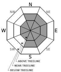
Overall, the avalanche danger is MODERATE near and above treeline. Isolated pockets of CONSIDERABLE danger may exist on select terrain features above treeline on Mt Shasta. LOW avalanche danger exists below treeline.


Avalanche Problem 1: Wind Slab
-
Character ?

-
Aspect/Elevation ?
-
Likelihood ?CertainVery LikelyLikelyPossible
 Unlikely
 -
Size ?HistoricVery LargeLargeSmall

The wind slab avalanche problem continues. Northwest wind beginning late on 12/26 will reach its zenith today. Six to twelve inches of dry, cold and unconsolidated snow was on the existing snow surface and available for wind transport. Redistribution and subsequent wind loading was visible all day yesterday. Wind slabs can be found near treeline on S-SE-E-NE-N aspects and above treeline all aspects. Human triggered wind slabs are possible. Isolated natural avalanches on steep slopes are also possible.
Transitions from scoured hard snow to soft deep snow, pillows of loaded snow, and textured snow surfaces may all be good indications of the wind slab presence. Wind slabs are most likely to be triggered on slopes steeper than 35 degrees just below ridgelines, on convex rollovers, and on unsupported terrain features.
Forecast Discussion
Several days of sunny skies and gradually increasing daytime high temperatures have settled and bonded the new snow to the old snow surface well. No avalanches have been reported or observed in several days. Cold temperatures have kept snow conditions dry and light and riding conditions have been great! Yesterday, daytime highs a few degrees warmer created moist snow surface conditions below and near treeline which may have re-froze into a light crust this morning on southerly aspects. Northerly aspects likely still hold dryer snow. Wind transport of light density snow was on high yesterday. Remember, even though the sky is blue, we can still get avalanches! Today, our primary concern will remain with the wind slab problem near and above treeline. Sustained northwest winds will continue through the morning hours today and load primarily (but not limited to) east and south aspects. Variable distribution and sensitivity of said wind slabs will require you to make cautious route finding decisions. You need to be able to identify a wind slab and features of concern. Be willing to stay off these slopes or manage appropriately. Ski and ride one at a time in avalanche terrain. Limit the number exposed to a potential avalanche. Don't regroup in avalanche run out zones. Don't expose others to risk with out their consent.
=============================================================
LOCAL AREA ROAD, NORDIC, AND SNOWMOBILE PARK STATUS:
The Sand Flat cross country ski trails are in good shape and ready for your cross country skis and snow shoes. These are backcountry routes marked with blue diamonds on trees. Trails are not groomed. Snow shoers, please blaze a parallel trail to cross country skiers staying out of the skin track. These trails can be accessed via the Everett Memorial Highway. Thank you, and enjoy!
The Mt. Shasta Nordic Center is OPEN for the season! Take advantage of this wonderful venue. Groomed trails accomodate both classic and skate skiing styles. Rentals available. Visit their website for more details. http://www.mtshastanordic.org
The Pilgrim Creek & Deer Mountain Snowmobile Parks are open, however there is no snow at these locations currently. One must drive down the 19 road (Military Pass) for several miles to get to consistent snow before unloading. Private industry is logging out there so watch out for log trucks. Head to our "Education" tab on our website and find the snowmobile section for trail information, grooming status, and other sledder resources.
The Castle Lake Road is OPEN. The Everett Memorial Highway is OPEN. The Castle Lake and Everett Hwy are plowed year round to the trailheads. The roads are not always first priority, so your dawn patrol powder mission might be ceased if the plow has not made it up yet. Siskiyou County does a great job keeping the roads clear. Be respectful of the plow drivers if you encounter them. If you get to Bunny Flat before or during when the plow is there, please park on the uphill, LEFT side of the parking lot as you drive in. This is uphill and lookers right of the bathrooms. Thank You!
The Five Red Flags of Avalanche Danger any time of year include: 1) Recent/current avalanche activity 2) Whumphing sounds or shooting cracks 3) Recent/current heavy snowfall 4) Strong winds transporting snow 5) Rapid warming or rain on snow.
Recent Observations
Upwards of 4-6 inches of settlement has occured in the snowpack over the past several days due to gradually warming temperatures and sunny skies. Recent observations and snowpit tests from the Castle Lake and Mt Eddy areas have indicated a stable snowpack. New snow from our pre-Christmas storm has remained light and dry from cold temperatures. A few sun induced roller balls were noted yesterday on lower elevation, southerly aspects, but nothing to cause concern for backcountry riders.
All that said, today will begin day 2 of our northwest wind event that has been cranking, averaging 20-30 mph over the past 36 hours. Plenty of blowing snow was visible across the forecast area near and above treeline yesterday. While it seemed much of the snow was sublimating (blowing away), new wind slabs several inches to feet deep were observed. No recent avalanches or signs of instability were reported yesterday however, today could be the day when new wind slabs reach their breaking point.
On another note, the snowpack on some cold, shady, northerly aspects near and above treeline has presented with a layer of weaker snow buried about 1 foot deep sitting below a crust. No avalanches have failed on this layer, but it has produced unstable results in stability tests. This layer (12/23) continues to heal and it is not a problem right now. However, it is worth keeping an eye on, especially if more snow/weight is added to the snowpack soon.
Weather and Current Conditions
Weather Summary
Pearly blue skies will result from the high pressure that builds over the area today. Expect northwest winds above treeline to continue through this afternoon and then begin to diminish and overall beautiful weather to prevail. The local temperature trend will increase with daytime highs a few degrees warmer than days past. Our next best chance of precipitation will not be for a couple days, perhaps beginning Friday and into the weekend. At this point, accumulation amounts don't look notable. More on that as the time draws near! Have a great day.
============================================================
In Mt Shasta City at 0500, we have a current temperature of 23 F.
On Mt Shasta (South Side) in the last 24 hours...
Old Ski Bowl - 7,600 feet, the current temperature is 35 degrees F. Snow on the ground totals 74 inches with 2 inches of settlement. Temperatures have ranged from 30 F to 37 F.
Grey Butte - 8,000 feet, the current temperature is 32 degrees F. Temperatures have ranged from 26 F to 33F. Winds have blown out of the northwest, averaging a steady 30 mph, with gusts as high as 64 mph.
Mt Eddy Range (West side of Interstate-5)...
Castle Lake - 5,600 feet, the current temperature is 24 degrees F. Temperatures have ranged from 24 F to 39 F. Snow on the ground totals 26 inches with 2 inches settlement.
Mt Eddy - 6,500 feet, the current temperature is 23 degrees F. Temperatures have ranged from 22 F to 36 F. Snow on the ground measures 31 inches with little settlment. Winds have averaged 2 mph with gusts to 12 mph, blowing southerly in direction.
THIS SEASON PRECIPITATION for MT SHASTA CITY: Since October 1st (the wet season), we have received 21.11 inches of water, normal is 14.19 inches, putting us at 148% of normal. For the month of December we received 4.64 inches of water, normal is 6.83 inches, putting us at 67% of normal, and finally... for the year of 2016 we've received 54.01 inches of water, normal is 42.19 inches, putting us at 128% of normal.
Always check the weather before you attempt to climb Mt Shasta. Further, monitor the weather as you climb. Becoming caught on the mountain in any type of weather can compromise life and limb. Be prepared.
| 0600 temperature: | 28 |
| Max. temperature in the last 24 hours: | 33 |
| Average wind direction during the last 24 hours: | Northwest |
| Average wind speed during the last 24 hours: | 20-30 mi/hr |
| Maximum wind gust in the last 24 hours: | 30-40 mi/hr |
| New snowfall in the last 24 hours: | 0 inches |
| Total snow depth: | 41 inches |
Two Day Mountain Weather Forecast
Produced in partnership with the Medford NWS
| For 7000 ft to 9000 ft | |||
|---|---|---|---|
|
Wednesday (4 a.m. to 10 p.m.) |
Wednesday Night (10 p.m. to 4 a.m.) |
Thursday (4 a.m. to 10 p.m.) |
|
| Weather | Mostly sunny. Breezy. | Mostly clear | Sunny |
| Temperature (°F) | 37 | 27 | 44 |
| Wind (mi/hr) | Northeast 5-10 mph | East 5 mph | South/Southeast 5 mph |
| Precipitation SWE / Snowfall (in) | / 0 | / 0 | / 0 |
| For 9000 ft to 11000 ft | |||
| Wednesday | Wednesday Night | Thursday | |
| Weather | Mostly sunny. Windy. | Mostly clear. Windy. | Sunny. Windy. |
| Temperature (°F) | 28 | 28 | 32 |
| Wind (mi/hr) | Northwest 25-30 mph | West/Southwest 0 | Southwest 10-15 mph |
| Precipitation SWE / Snowfall (in) | / 0 | / 0 | / 0 |

