

You are here
Avalanche Advisory for 2017-01-08 07:11:26
- EXPIRED ON January 9, 2017 @ 7:11 amPublished on January 8, 2017 @ 7:11 am
- Issued by Andrew Kiefer - Mt Shasta Avalanche Center
Bottom Line
HIGH avalanche danger exists on all aspects and at all elevations. Very dangerous conditions exist in the backcountry today. Travel in and below avalanche terrain is not recommended. Wet slab, wind slab, and persistent slab avalanches are all significant concerns today. Natural avalanches are likely, and human-triggered avalanches are very likely.


Avalanche Problem 1: Wet Slab
-
Character ?

-
Aspect/Elevation ?
-
Likelihood ?CertainVery LikelyLikelyPossible
 Unlikely
 -
Size ?HistoricVery LargeLargeSmall

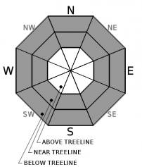
Heavy rain began at 1am this morning, and will continue throughout the day up to 7500ft. A wet slab avalanche problem will be a concern on all aspects near and above treeline where rain on snow is expected today. A natural avalanche cycle is likely when rain is quickly introduced to a dry snowpack. The new storm snow as well as the entire snowpack will rapidly loose strength as a major rain event occurs today.
Avalanche Problem 2: Wind Slab
-
Character ?

-
Aspect/Elevation ?
-
Likelihood ?CertainVery LikelyLikelyPossible
Unlikely
-
Size ?HistoricVery LargeLargeSmall
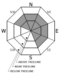
South/southwest winds have created fresh wind slabs on NW-N-NE-E-SE aspects near and above treeline. These areas of loaded snow are already 2-6ft deep, and will grow as strong southwest winds continue today. Wind slab avalanches on slopes 35 degrees and steeper are likely to occur naturally, and very likely to be human triggered. Watch for blowing snow, cornice formation, pillows of loaded snow, and abrupt transitions from shallow areas of snow to areas of deeper snow.
Avalanche Problem 3: Persistent Slab
-
Character ?

-
Aspect/Elevation ?
-
Likelihood ?CertainVery LikelyLikelyPossible
Unlikely
-
Size ?HistoricVery LargeLargeSmall
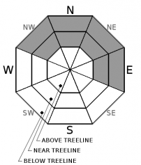
A weak layer of snow was buried on 12/23. The Christmas and New Years storms added 2-3ft of snow and weight on top of this layer, but no avalanches occurred. With the recent addition of new snow and weight, and more snow and rain expected today and tonight, the 12/23 layer may reach its tipping point.
This avalanche problem has a specific distribution to near and below treeline elevations, and NW-N-NE-E aspects. Uncertainty exists as to how the 12/23 layer will behave in the near future, and if the 1/1 layer will also be problematic. For the past 2 weeks, stability tests targeting these layers have been inconsistent. On several occasions however, stability tests have produced unstable results, and our persistent slab avalanche problem is a concern. With the additional snow, our persistent slab problem is trending toward a deep slab problem.
Forecast Discussion
Very dangerous avalanche conditions exist in the backcountry. Wet slab, wind slab, and persistent slab avalanches are all problems for today. Avalanches are likely to occur naturally, and very likely to be human triggered. HIGH avalanche danger exists on all aspects at all elevations, and travel in and below avalanche terrain is not recommended today. Large and dangerous avalanches could occur. Rain on snow has the potential to create a widespread avalanche cycle. Freezing levels will be on the rise today. Significant precipitation will occur, and 7500ft will likely mark the transition from rain to snow.
Recent Observations
Our advisory area has received 1.63 inches of snow water equivalent (SWE) and 10-12 inches of new snow in the past 24 hours. Areas up to 5800ft have received rain on snow, and freezing levels are quickly rising to 7500ft. Steady south/southwest winds have blown 20-30 mph with gusts over 50 mph. These numbers all meet or exceed threshold values for snowpack instability, and both natural and human triggered avalanches are expected with these conditions.
Yesterday between 6am and 11am, we received the bulk of our precipitation in the past 24 hours. The snowfall was heavy, and accumulation rates during this window of time were up to 2 inches an hour. Yesterday, snowfall continued throughout the afternoon and evening, and a transition to rain occurred up to the 5800ft level by 1am this morning.
Weather and Current Conditions
Weather Summary
Another potent frontal system is moving through Northern California, bringing ample moisture and rising freezing levels to our advisory area. The National Weather Service has issued a Flood Watch for Siskiyou County in effect now through 10pm tonight. Heavy rain and snow is expected with freezing levels reaching 7500ft today.
In the past 24 hours, our remote weather stations report 1.63 inches of snow water equivalent (SWE) and 10-12 inches of new snow. A transition to rain has already occurred this morning up to elevations of 5800ft and rising. Our advisory area is expected to receive an additional 1.65 inches of water is by 10pm tonight. Below 7500ft, this precipitation should come as rain. 9000ft and above may receive 24-30 inches of new snow today. Temperatures for 6000ft levels should reach highs in the upper 30’s. Strong winds will blow from the south/southwest.
As a cold front moves into the area tonight, freezing levels will drop slightly to 6500ft, and 3500ft by tomorrow. More rain and snow is expected, with Mount Shasta City receiving rain. The 6000ft elevations have a chance to receive 3-4 inches of new snow if expected freezing levels verify. Areas above 9000ft have a chance to receive an additional 6-12 inches of snow overnight. A Winter Storm Watch will be in effect Monday through Tuesday.
===========================================================
In Mt Shasta City at 0500, we have a current temperature of 41 F and rain on snow.
On Mt Shasta (South Side) in the last 24 hours...
Old Ski Bowl - 7,600 feet, the current temperature is 31 degrees F. Temperatures have ranged from 18 F to 31 F. Snow on the ground totals 98 inches with 11 inches of new snow.
Grey Butte - 8,000 feet, the current temperature is 31 degrees F. Temperatures have ranged from 17 F to 31 F. Winds have averaged 20-30 mph with gusts to 56 mph, blowing out of the southwest.
Mt Eddy Range (West side of Interstate-5)...
Castle Lake - 5,600 feet, the current temperature is 34 degrees F. Temperatures have ranged from 22 F to 35 F. Snow on the ground totals 53 inches with 10 inches of new snow and 3 inches of settlement due to rain on snow.
Mt Eddy - 6,500 feet, the current temperature is 34 degrees F. Temperatures have ranged from 21 F to 34 F. Snow on the ground measures 54 inches with 7 inches of new snow and 1 inch of settlement. Winds have averaged 1-3 mph with gusts to 17 mph, blowing out of the south/southwest.
THIS SEASON PRECIPITATION for MT SHASTA CITY: Since October 1st (the wet season), we have received 23.96 inches of water, normal is 16.86 inches, putting us at 142% of normal. For the month of January and for the year of 2017, we received 2.80 inches of water, normal is 1.65 inches, putting us at 170% of normal.
Always check the weather before you attempt to climb Mt Shasta. Further, monitor the weather as you climb. Becoming caught on the mountain in any type of weather can compromise life and limb. Be prepared.
| 0600 temperature: | 33 |
| Max. temperature in the last 24 hours: | 33 |
| Average wind direction during the last 24 hours: | Southwest |
| Average wind speed during the last 24 hours: | 10-15 mi/hr |
| Maximum wind gust in the last 24 hours: | 30 mi/hr |
| New snowfall in the last 24 hours: | 8 inches |
| Total snow depth: | 59 inches |
Two Day Mountain Weather Forecast
Produced in partnership with the Medford NWS
| For 7000 ft to 9000 ft | |||
|---|---|---|---|
|
Sunday (4 a.m. to 10 p.m.) |
Sunday Night (10 p.m. to 4 a.m.) |
Monday (4 a.m. to 10 p.m.) |
|
| Weather | Rain/Snow and Windy. Chance of precipitation 100% | Rain/Snow and Windy. Precipitation should become all snow after 10pm. Chance of precipitation 100% | Heavy Snow and Breezy. Chance of precipitation 100% |
| Temperature (°F) | 38 | 24 | 27 |
| Wind (mi/hr) | South 25-35 mph | South 25-30 mph | South/southwest 20-30 mph |
| Precipitation SWE / Snowfall (in) | / 0 | / 2-4 | / 12-18 |
| For 9000 ft to 11000 ft | |||
| Sunday | Sunday Night | Monday | |
| Weather | Heavy Snow and Windy. | Heavy Snow and Windy. | Heavy Snow and Windy. |
| Temperature (°F) | 29 | 5 | 12 |
| Wind (mi/hr) | South/southwest 50-60 mph, Gusting 70+ mph | Southwest 24-30 | West/southwest 40-50 mph, Gusting 70+ |
| Precipitation SWE / Snowfall (in) | / 24-30 | / 7-11 | / 15-21 |

