

You are here
Avalanche Advisory for 2017-01-09 07:17:06
- EXPIRED ON January 10, 2017 @ 7:17 amPublished on January 9, 2017 @ 7:17 am
- Issued by Andrew Kiefer - Mt Shasta Avalanche Center
Bottom Line
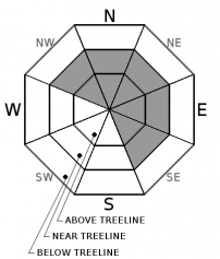
HIGH avalanche danger exists on all aspects above treeline and near treeline. CONSIDERABLE avalanche danger exists on all aspects below treeline. Wind slab, storm slab, and persistent slab avalanche problems present significant concerns today. Natural avalanches are likely and human triggered avalanches are very likely. Very dangerous avalanche conditions exist in the backcountry, and travel in or below avalanche terrain is not recommended.


Avalanche Problem 1: Wind Slab
-
Character ?

-
Aspect/Elevation ?
-
Likelihood ?CertainVery LikelyLikelyPossible
 Unlikely
 -
Size ?HistoricVery LargeLargeSmall

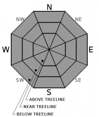
Southwest/south winds continue to create fresh wind slabs on NW-N-NE-E-SE aspects near and above treeline. Wind slabs are several feet thick on lee slopes and loaded terrain features. Wind slab avalanches occur on slopes 35 degrees and steeper. These avalanches have the potential to be large and very dangerous. Snow is available for transport, and wind is actively redistributing snow unevenly throughout the terrain. Look for evidence of wind transported snow including drifts, plumes, cornice growth, and variable snow surface penetration. Today, avoid traveling in or below avalanche terrain with recent wind deposits.
Avalanche Problem 2: Storm Slab
-
Character ?

-
Aspect/Elevation ?
-
Likelihood ?CertainVery LikelyLikelyPossible
Unlikely
-
Size ?HistoricVery LargeLargeSmall
The majority of the advisory area is expected to receive 8-12 inches of new snow and 1.5 inches of snow water equivalent today. As new snow is quickly added to the snowpack, storm slabs will likely build and become a concern on all aspects at all elevations. Storm slabs may fail within the new snow or at the new snow/old snow interface on slopes 30 degrees and steeper. Monitor snowfall accumulation and rate throughout the day, and assess how the new snow is bonding to itself, and to the old snow surface.
Avalanche Problem 3: Persistent Slab
-
Character ?

-
Aspect/Elevation ?
-
Likelihood ?CertainVery LikelyLikelyPossible
Unlikely
-
Size ?HistoricVery LargeLargeSmall
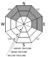
A weak layer of snow was buried on 12/23, and a persistent slab avalanche problem remains throughout the advisory area on NW-N-NE-E aspects near and below treeline.
There have been no reports of persistent slab avalanches occurring on the 12/23 layer. The distribution of this problem is isolated, and it primarily has been found on north facing, near treeline slopes. Evidence suggesting that the persistent slab avalanche problem exists is rare and hard to find. With yesterday’s rain on snow event, free water most likely penetrated through the snowpack down to the 12/23 layer. This rain event, which today is followed by a significant cooling trend, may have erased the presence of the persistent slab avalanche problem. In the immediate future, the persistent slab avalanche problem may still pose a concern. That being said, the recent weather events have contributed to the removal of this weak layer in the long term.
Forecast Discussion
The rain is expected to transition to snow at all elevations in the advisory area today. A cooling trend in place will work to solidify the snowpack, and wet avalanche activity will be put on hold. The snowpack is currently experiencing rapid change. Large avalanches have the potential to occur in many areas, and very dangerous conditions exist in the backcountry. Monitor the weather and look for signs of instability. Avoid traveling in or below avalanche terrain.
Recent Observations
In the past 24 hours, Mount Shasta City received 2.93 inches of rain, while the Old Ski Bowl has received 7 inches of wet snow mixed with rain and 2.18 inches of snow water equivalent. Since January 6th, our advisory area has received a 3.5 inches of water that has fallen as a mix of rain and snow.
Freezing levels reached 7500ft yesterday before dropping to town level by this morning. Continuous snowfall has occurred above 9000ft since late Friday night. Exact snowfall totals for upper elevation terrain are unknown, but confidence is high that several feet of snow have accumulated.
Yesterday, observations targeted below treeline terrain. Glide cracks were observed on a north-facing slope at 3240ft (see photos in Observations). The glide cracks likely occurred between 1am-11am yesterday morning. Evidence of the rain event yesterday was obvious in below treeline terrain observed on a drive to Castle Lake and a drive to Bunny Flat. Rain runnels were widespread (see photo in Observations). The height of the snowpack decreased by 7 inches in some areas below 7500ft due to the rain on snow event.
Weather and Current Conditions
Weather Summary
The advisory area will continue to experience extremely active weather for the next few days. A rich moisture plume will remain aimed at Northern California through tonight. Freezing levels continue to drop, and are expected to lower to 3000ft by mid morning, and remain at this level or lower through Tuesday afternoon. The National Weather Service has issued a Winter Storm Warning in effect until 10am Tuesday.
Today and tonight, snowfall will be plentiful at elevations 3000ft and above. The 6,000ft level should see 8-12 inches of snow today, and an additional 8-12 inches of snow overnight. Temperatures will be 20-25 degrees, and south winds will be 10-15 mph with gusts to 45 mph.
Up to 5 inches of water is expected in the advisory area by Wednesday. This will fall as a mix of rain and snow. A mild and very wet system will arrive tomorrow afternoon bringing freezing levels up to 6000ft, before dropping to 4000ft by Wednesday. Upper elevations are expected to receive several feet of snow.
===========================================================
In Mt Shasta City at 0500, we have a current temperature of 37 F with 2.93 inches of rain in the past 24 hours.
On Mt Shasta (South Side) in the last 24 hours...
Old Ski Bowl - 7,600 feet, the current temperature is 22 degrees F. Temperatures have ranged from 22 F to 32 F. Snow on the ground totals 101 inches with 7 inches of new snow, 2.18 inches SWE, and 4 inches of settlement.
Grey Butte - 8,000 feet, the current temperature is 26 degrees F. Temperatures have ranged from 26 F to 31 F. Winds have averaged 25-35 mph with gusts to 64 mph, blowing out of the southwest.
Mt Eddy Range (West side of Interstate-5)...
Castle Lake - 5,600 feet, the current temperature is 28 degrees F. Temperatures have ranged from 28 F to 37 F. Snow on the ground totals 47 inches with a loss in snow height of 6 inches due to rain on snow.
Mt Eddy - 6,500 feet, the current temperature is 25 degrees F. Temperatures have ranged from 25 F to 37 F. Snow on the ground measures 50 inches with a loss in snow height of 4 inches due to rain on snow. Winds have averaged 2-4 mph with gusts to 21 mph, blowing out of the southwest and shifting to the southeast.
THIS SEASON PRECIPITATION for MT SHASTA CITY: Since October 1st (the wet season), we have received 26.89 inches of water, normal is 17.01 inches, putting us at 158% of normal. For the month of January and for the year of 2017, we received 5.73 inches of water, normal is 1.89 inches, putting us at 303% of normal.
Always check the weather before you attempt to climb Mt Shasta. Further, monitor the weather as you climb. Becoming caught on the mountain in any type of weather can compromise life and limb. Be prepared.
| 0600 temperature: | 27 |
| Max. temperature in the last 24 hours: | 36 |
| Average wind direction during the last 24 hours: | Southwest |
| Average wind speed during the last 24 hours: | 10-15 mi/hr |
| Maximum wind gust in the last 24 hours: | 30 mi/hr |
| New snowfall in the last 24 hours: | 0 inches |
| Total snow depth: | 56 inches |
Two Day Mountain Weather Forecast
Produced in partnership with the Medford NWS
| For 7000 ft to 9000 ft | |||
|---|---|---|---|
|
Monday (4 a.m. to 10 p.m.) |
Monday Night (10 p.m. to 4 a.m.) |
Tuesday (4 a.m. to 10 p.m.) |
|
| Weather | Heavy Snow and Windy. Chance of precipitation 100% | Heavy Snow and Windy. Chance of precipitation 100%. | Heavy Snow and Windy. Chance of precipitation 100% |
| Temperature (°F) | 28 | 26 | 32 |
| Wind (mi/hr) | South/southwest 20-25 mph | South/southwest 25-30 mph | South/southwest 20-30 mph |
| Precipitation SWE / Snowfall (in) | / 12-18 | / 13-19 | / 22-28 |
| For 9000 ft to 11000 ft | |||
| Monday | Monday Night | Tuesday | |
| Weather | Heavy Snow and Windy. | Heavy Snow and Windy. | Heavy Snow and Windy. |
| Temperature (°F) | 11 | 11 | 22 |
| Wind (mi/hr) | West/southwest 50-60 mph, Gusting 70+ mph | West/southwest 14-20 | South/southwest 50-60 mph, Gusting 70+ |
| Precipitation SWE / Snowfall (in) | / 14-20 | / 18-24 | / 28-34 |

