

You are here
Avalanche Advisory for 2017-01-18 06:55:44
- EXPIRED ON January 19, 2017 @ 6:55 amPublished on January 18, 2017 @ 6:55 am
- Issued by Nick Meyers - Shasta-Trinity National Forest
Bottom Line
LOW avalanche danger this morning is expected to rise rapidly today and reach a CONSIDERABLE to HIGH danger rating by afternoon hours. A winter storm warning is in effect bringing hurricane force winds and feet of new snow to the forecast area over the next 24 hours. Wind slabs, storm slabs and cornices will increase in size, distribution and sensitivity as the day progresses. Expect dangerous avalanche conditions in the afternoon hours on slopes steeper than 30 degrees.


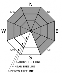
Avalanche Problem 1: Wind Slab
-
Character ?

-
Aspect/Elevation ?
-
Likelihood ?CertainVery LikelyLikelyPossible
 Unlikely
 -
Size ?HistoricVery LargeLargeSmall

Heavy, wet snow will rapidly build new wind slabs within the forecast area today. Hurricane force winds may limit wind slab formation above treeline, however wind slabs are certain in areas where more moderate wind speeds exist near and below treeline. Above treeline, high winds may result in deposition lower on slopes. Avoid wind loaded slopes steeper than 30 degrees today, especially in the afternoon hours.
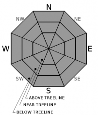
Avalanche Problem 2: Storm Slab
-
Character ?

-
Aspect/Elevation ?
-
Likelihood ?CertainVery LikelyLikelyPossible
Unlikely
-
Size ?HistoricVery LargeLargeSmall
Today will present good characteristics for storm slab production. Do not underestimate the potential for slab fracture to occur across terrain, perhaps farther than expected. Areas near treeline and below treeline will likely host the best storm slab potential. Storm slabs will be at their greatest threat during the afternoon hours as snow rapidly accumulates. Bed surface interfaces could present anywhere within the new snow or at the old/new snow.
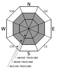
Avalanche Problem 3: Cornice
-
Character ?

-
Aspect/Elevation ?
-
Likelihood ?CertainVery LikelyLikelyPossible
Unlikely
-
Size ?HistoricVery LargeLargeSmall
Ridgelines within the forecast area still hold small to large cornice features, particularly on the west side. Rapid accumulation of new snow will add weight to remaining cornices. Either new cornices could be easily triggered and/or new snow will add weight to old cornices and cause the whole feature to break off.
Forecast Discussion
Just like we learn in Avalanche Awareness... two of the five red flags of avalanche danger will be hoisted on this fine Wednesday. Read: heavy snow and wind! At times, we could see more than 1 inch of snow per hour paired up with very strong southerly winds. Existing weak layers pose little concern. All instabilities will most likely lie within new wind and storm slab layers and the old snow/new snow interface. Rapid accumulation of new snow and wind loading is forecast for today. Given the predictions hold true, the avalanche danger will rapidly rise. Expect LOW danger currently this morning, MODERATE danger mid-late morning and CONSIDERABLE to HIGH danger by the afternoon hours. Natural and human triggered wind and storm slab avalanches are likely by this evening. Unstable cornice features are likely also. Conservative travel choices are a must today.
Recent Observations
We had one new observation come in from the Mt Shasta Ski Park Ski Patrol yesterday. Overall, it's been about a week since our last storm and the same amount of time since any avalanche activity. Temperatures are 10-15 degrees cooler this morning than yesterday at this time and the current storm is knocking on the door. New snow will fall on variable snow surfaces, including wind scoured snow, melt-freeze crusts, firm and icy snow, and powder snow in shady, cold, and wind-protected areas. Very sporadic surface hoar formation has been observed near Grey Butte and in the Castle Lake area. The warm temperatures recently likely melted the majority of these formations, and any remaining surface hoar is not expected to cause significant concern with the incoming storms.
Weather and Current Conditions
Weather Summary
The National Weather Service has issued a winter storm warning in effect until 4am PST Thursday for blizzard conditions on the upper mountain today and tonight with heavy snow and hurricane force winds. Not much more needs to be said about that!
Hold on to your hats because a winter storm is on the doorstep. This morning things are starting to get going with strong, gusty winds in town and light snow falling. Today, forecasts are predicting 1.34 inches of snow water equivalent by 10pm tonight. Snow levels will remain from about 3,500 to 4,000 feet, cooling and lowering to town or below by tomorrow. Paired up with this bucket of precipitation are very windy conditions, hurricane force actually, on the upper mountain. One can expect steady wind speeds of 50+ mph with gusts well into the 60 and 70 mph range. We highly doubt anybody will be up there to experience this, but just in case you were curious. Lower elevations will still experience high winds. This short, potent storm will diminish tomorrow and serve the break in the storm for Thursday. Before we get to excited about the next active weather pattern for Friday and the weekend, lets get through this first wave. But yes, cooler temps, more precip and wind for the weekend! Travel conditions will be hazardous today in the Weed to Dunsmuir area. More than 1 inch/hour of snowfall is expected at times. Rubber side down!
===========================================================
In Mt Shasta City at 0500, we have a current temperature of 35 F with light snow/rain and windy.
On Mt Shasta (South Side) in the last 24 hours...
Old Ski Bowl - (7,600ft) Not recording data at this time. We are working to get this station up and running again ASAP.
Grey Butte - 8,000 feet, the current temperature is 23 degrees F. Temperatures have ranged from 23 F to 43 F. Winds have averaged 10-15 mph with gusts to 28 mph, blowing out of the west.
Mt Eddy Range (West side of Interstate-5)...
Castle Lake - 5,600 feet, the current temperature is 26 degrees F. Temperatures have ranged from 26 F to 41 F. Snow on the ground totals 53 inches with no new snow and little settlement.
Mt Eddy - 6,500 feet, the current temperature is 27 degrees F. Temperatures have ranged from 26 F to 50 F. Snow on the ground measures 56 inches with no new snow and little settlement. Winds have averaged 2-3 mph with gusts to 13 mph, blowing out of the south.
THIS SEASON PRECIPITATION for MT SHASTA CITY: Since October 1st (the wet season), we have received 28.27 inches of water, normal is 19.26 inches, putting us at 146% of normal. For the month of January and for the year of 2017, we received 7.11 inches of water, normal is 4.05 inches, putting us at 175% of normal.
Always check the weather before you attempt to climb Mt Shasta. Further, monitor the weather as you climb. Becoming caught on the mountain in any type of weather can compromise life and limb. Be prepared.
| 0600 temperature: | 26 |
| Max. temperature in the last 24 hours: | 35 |
| Average wind direction during the last 24 hours: | Southerly |
| Average wind speed during the last 24 hours: | 5-10 mi/hr |
| Maximum wind gust in the last 24 hours: | 20-30 mi/hr |
| New snowfall in the last 24 hours: | .5-1 inches |
| Total snow depth: | 62 inches |
Two Day Mountain Weather Forecast
Produced in partnership with the Medford NWS
| For 7000 ft to 9000 ft | |||
|---|---|---|---|
|
Wednesday (4 a.m. to 10 p.m.) |
Wednesday Night (10 p.m. to 4 a.m.) |
Thursday (4 a.m. to 10 p.m.) |
|
| Weather | Snow. The snow could be heavy at times. Windy. Chance of precipitation is 100%. | Snow before 10pm, then snow showers after 10pm. The snow could be heavy at times. Windy. Chance of precipitation is 100%. | Snow showers likely before 4pm, then snow after 4pm. Chance of precipitation is 80%. |
| Temperature (°F) | Falling to 25 by 3pm | 22 | 28 |
| Wind (mi/hr) | South 25-30 mph | South 20-25 mph | Southwest 5-10 mph |
| Precipitation SWE / Snowfall (in) | / 15-20 | / 5-10 | / 1-3 |
| For 9000 ft to 11000 ft | |||
| Wednesday | Wednesday Night | Thursday | |
| Weather | Snow. The snow could be heavy at times. Wind chill values as low as -5. Windy; Chance of precipitation is 100%. | Snow before 10pm, then snow showers after 10pm. The snow could be heavy at times. Wind chill values as low as -14. Windy. Chance of precipitation is 100%. | Snow showers likely before 4pm, then snow after 4pm. Wind chill values as low as -7. Chance of precipitation is 80%. |
| Temperature (°F) | Falling to 21 by 5pm | 11 | 12 |
| Wind (mi/hr) | Southwest 60-65 mph | South 20-25 | West 15-20 mph |
| Precipitation SWE / Snowfall (in) | / 20-25 | / 10-15 | / 1-3 |

