

You are here
Avalanche Advisory for 2017-01-19 07:01:18
- EXPIRED ON January 20, 2017 @ 7:01 amPublished on January 19, 2017 @ 7:01 am
- Issued by Nick Meyers - Shasta-Trinity National Forest
Bottom Line
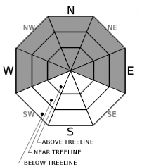
Several feet of new snow and gale force south wind over the last 24 hours has created HIGH avalanche danger near and above treeline. CONSIDERABLE danger exists below treeline. Stay off of and out from underneath slopes steeper than 30 degrees today. Wind slabs, storm slabs and cornices have gained size, distribution and sensitivity. An additional winter storm warning is in effect from 10pm this evening to 4pm PST Friday.


Avalanche Problem 1: Wind Slab
-
Character ?

-
Aspect/Elevation ?
-
Likelihood ?CertainVery LikelyLikelyPossible
 Unlikely
 -
Size ?HistoricVery LargeLargeSmall

Wind slabs from yesterday will be several feet thick. Additional wind loading will occur today. Southerly winds have loaded primarily NW-N-NE slopes, but not limited too. Extreme winds have likely loaded many mid-slope starting zones near and above treeline. The effects of the wind were observed way below treeline yesterday, as low as 5,500 feet. Wind slab weak layers may lie within the new snow, could propagate below our most recent crust, and/or step down into even deeper layers in the snowpack. Avoid wind loaded slopes steeper than 30 degrees today. Pay attention to terrain above you.
Avalanche Problem 2: Storm Slab
-
Character ?

-
Aspect/Elevation ?
-
Likelihood ?CertainVery LikelyLikelyPossible
Unlikely
-
Size ?HistoricVery LargeLargeSmall
Storm slabs remain possible today. Spacial distribution of the storm slab problem yesterday was mixed as cohesive snow was hit or miss. Do not underestimate the potential for slab fracture to occur across terrain, perhaps farther than expected. Areas near treeline and below treeline will host the best storm slab potential. Bed surface interfaces could present anywhere within the new snow or at the old/new snow.
Avalanche Problem 3: Cornice
-
Character ?

-
Aspect/Elevation ?
-
Likelihood ?CertainVery LikelyLikelyPossible
Unlikely
-
Size ?HistoricVery LargeLargeSmall
Ridgelines within the forecast area still hold small to large cornice features, particularly on the west side. Rapid accumulation of new storm snow will add weight to remaining cornices. Either new cornices could be easily triggered and/or new snow will add weight to old cornices and cause the whole feature to break off.
Forecast Discussion
Now THAT was a snow storm... and it's not over yet. Yesterday brought a full value system to the Mt Shasta area with snow totals measured in feet. With the Everitt Memorial Highway and Mt Shasta Ski Park CLOSED, it's unlikely that many folks will be able to venture into avalanche terrain today. That said, if you do, perhaps on a snowmobile... extreme caution will be mandatory. Wind slabs, storm slabs and cornices will have their claws out waiting to grab and pull you under. These problems can be easily fooled by choosing terrain wisely. Bottom line: Stay off of and out from underneath slopes steeper than 30 degrees today. Another strong winter storm will impact the area beginning tonight. A second dose of heavy snow and southerly wind will continue to rapidly load the snowpack. Small to very large avalanches are possible for the next several days.
Recent Observations
New snow amounts for the last 24 hours range from 15-25 inches, and more in wind drifted areas. Temperatures remain near the same as yesterday. We only saw a couple degrees temperature swing between highs and lows. Winds have been straight south with a few southwest forays, averaging 15-20 mph with gusts into the 40's. Winds are likely much higher along exposed ridgelines and on the upper mountain.
Yesterday, my partner and I made our way to Bunny Flat, enroute to make some weather station repairs at the Old Ski Bowl site and also make some snow observations along the way. While some people enjoy storm chasing, we took part in storm diving. Head first we went into an impressive storm. Extremely rapid snow accumulation and gale force winds were observed below, near and above treeline. Visibility ranged from complete whiteout conditions to 1/8 mile. At 1330, we recorded 25cm of new snow on top of our recent melt/freeze crust layer. At 1500, another observer on Gray Butte recorded 40cm. A snowpit (see most recent observation for video, photos and pit profile) on a easterly aspect near treeline indicated that failures could be possible in several locations within the snowpack. Failure within the new snow and just below our most recent melt/freeze crust layer were easy to moderately instigated. Temperatures in the 20's F made for light density snow, however the snow became more wet and sticky below 6,500 feet. Wind slabs were in their prime and slabs were up to several feet thick and very dense. Storm slab properties were not great at my pit location, but certainly likely elsewhere. By the time we returned to Bunny Flat, our tracks were filled in.
Weather and Current Conditions
Weather Summary
Here we go again! The NWS has issued a winter weather advisory in effect until 10am PST this morning. Today will actually be the "break" in the storm action, even though some lingering snow showers will impact the area. Get your shoveling and plowing caught up now because another winter storm warning is in effect from 10pm this evening to 4pm PST Friday. We are looking at snow/water equivalents of .36" today, .85" tonight and .37" tomorrow with snow levels to town or lower. This storm won't be quite as potent as this past one, but nothing to shake a stick at. Do not let go of your hat, south to southwest winds will ebb and flow over the course of the weekend but overall continue to blow on the mountain. Today expect south winds to be diminished but not absent. Another strong frontal system will bring MORE snow over the weekend with another foot or more of new snow possible for Mt Shasta City. More on that later. For today, scattered showers, perhaps a few inches of new snow. If that giant plow berm in your driveway wore you out... it's only the beginning. Rest up!
===========================================================
In Mt Shasta City at 0500, we have a current temperature of 33 F.
On Mt Shasta (South Side) in the last 24 hours...
Old Ski Bowl - (7,600ft) Not recording data at this time. We are working to get this station up and running again ASAP. Sand Flat (6,750 feet) is recording 18 new inches of snow in the last 24 hours.
Grey Butte - 8,000 feet, the current temperature is 20 degrees F. Temperatures have ranged from 19 F to 20 F. Winds have averaged 15-20 mph with gusts to 49 mph, blowing out of the south.
Mt Eddy Range (West side of Interstate-5)...
Castle Lake - 5,600 feet, the current temperature is 25 degrees F. Temperatures have ranged from 24 F to 26 F. Snow on the ground totals 70 inches with 17 inches new snow and little settlement.
Mt Eddy - 6,500 feet, the current temperature is 23 degrees F. Temperatures have ranged from 22 F to 24 F. Snow on the ground measures 74 inches with 18 inches new snow and little settlement. Winds have averaged 2-4 mph with gusts to 20 mph, blowing out of the southwest.
THIS SEASON PRECIPITATION for MT SHASTA CITY: Since October 1st (the wet season), we have received 29.53 inches of water, normal is 19.48 inches, putting us at 151% of normal. For the month of January and for the year of 2017, we received 8.37 inches of water, normal is 4.27 inches, putting us at 196% of normal.
Always check the weather before you attempt to climb Mt Shasta. Further, monitor the weather as you climb. Becoming caught on the mountain in any type of weather can compromise life and limb. Be prepared.
| 0600 temperature: | 24 |
| Max. temperature in the last 24 hours: | 26 |
| Average wind direction during the last 24 hours: | South |
| Average wind speed during the last 24 hours: | 15-20 mi/hr |
| Maximum wind gust in the last 24 hours: | 40+ mi/hr |
| New snowfall in the last 24 hours: | 18-24 inches |
| Total snow depth: | 80 inches |
Two Day Mountain Weather Forecast
Produced in partnership with the Medford NWS
| For 7000 ft to 9000 ft | |||
|---|---|---|---|
|
Thursday (4 a.m. to 10 p.m.) |
Thursday Night (10 p.m. to 4 a.m.) |
Friday (4 a.m. to 10 p.m.) |
|
| Weather | Snow showers. Chance of precipitation is 90%. | Snow showers before 10pm, then snow after 10pm. The snow could be heavy at times. Windy. Chance of precipitation is 100%. | Snow. The snow could be heavy at times. Windy. Chance of precipitation is 100%. |
| Temperature (°F) | 28 | 23 | 27 |
| Wind (mi/hr) | Southwest 5-10 mph | South 10-15 mph | South 15-20 mph |
| Precipitation SWE / Snowfall (in) | / 2-5 | / 6-12 | / 8-14 |
| For 9000 ft to 11000 ft | |||
| Thursday | Thursday Night | Friday | |
| Weather | Snow showers. Wind chill values as low as -7. Chance of precipitation is 90%. | Snow showers before 10pm, then snow after 10pm. The snow could be heavy at times. Wind chill values as low as -16. Windy. Chance of precipitation is 100%. | Snow. The snow could be heavy at times. Wind chill values as low as -17. Windy. Chance of precipitation is 100%. |
| Temperature (°F) | 11 | 10 | 13 |
| Wind (mi/hr) | Southwest 15-20 mph | Southwest 2-5 | Southwest 30-35 mph |
| Precipitation SWE / Snowfall (in) | / 2-5 | / 8-14 | / 10-15 |

