

You are here
Avalanche Advisory for 2017-01-23 07:01:30
- EXPIRED ON January 24, 2017 @ 7:01 amPublished on January 23, 2017 @ 7:01 am
- Issued by Andrew Kiefer - Mt Shasta Avalanche Center
Bottom Line
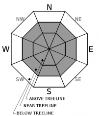
HIGH avalanche danger exists above treeline and near treeline on wind loaded slopes steeper than 35 degrees. CONSIDERABLE danger exists below treeline. Wind slab, storm slab, and cornice fall avalanches all have the potential to be very large and dangerous today. Travel in avalanche terrain is not recommended, and avalanche path runout zones should be avoided.


Avalanche Problem 1: Wind Slab
-
Character ?

-
Aspect/Elevation ?
-
Likelihood ?CertainVery LikelyLikelyPossible
 Unlikely
 -
Size ?HistoricVery LargeLargeSmall

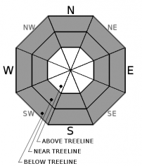
Moderate to strong winds have blown for the past several days and have created wind slabs on all aspects near and above treeline. Wind slabs continue to build in size, and the potential exists for large and destructive wind slab avalanches. Winds have primarily blown from the south, but significant variability has occurred in the redistribution of new snow. Areas of loaded snow exist on terrain features even on windward slope aspects, especially within the several thousand feet of alpine terrain on Mount Shasta. Avoid traveling on or below steep and wind-loaded slopes today.
Avalanche Problem 2: Storm Slab
-
Character ?

-
Aspect/Elevation ?
-
Likelihood ?CertainVery LikelyLikelyPossible
Unlikely
-
Size ?HistoricVery LargeLargeSmall
Several feet of new snow have been added to the snowpack recently, creating storm slabs on all aspects near and below treeline. Storm slabs may fail within the new snow, or at the old snow/new snow interface. Storm slab avalanche concerns remain elevated during and immediately following storm events. In many locations throughout the advisory area, the new storm snow presents a right side up configuration, with light snow resting on top of compressed and firm snow. In addition, the new snow has bonded relatively well to the old snow surface. These are good signs for the longterm, but the snowpack needs time now to adjust to the significant new load of snow and weight. Avoid slopes steeper than 30 degrees where evidence of an unstable storm slab problem exists.
Avalanche Problem 3: Cornice
-
Character ?

-
Aspect/Elevation ?

-
Likelihood ?CertainVery LikelyLikelyPossible
Unlikely
-
Size ?HistoricVery LargeLargeSmall
Small to large cornice features exist on many ridgelines throughout the advisory area. Rapid snow accumulation and wind transport are adding weight to existing cornices, and building new cornice features. Cornices are often overhung and can break in very unpredictable ways. If cornices fail, they pose a significant risk of triggering slopes below. Be sure to stand back on ridgelines, and avoid traveling on or below avalanche terrain threatened by cornice hazard.
Forecast Discussion
The most impressive storm series of the season so far is coming to a close. Snow totals for the week are over 6 feet throughout the majority of the advisory area. The major precipitation events have already occurred, but 2-4 inches of new snow may fall before high pressure moves into the area by tomorrow. The significant amount of new snow has created very dangerous avalanche conditions in the backcountry. Natural avalanches are likely, and human-triggered avalanches are very likely in upper elevation terrain. Today, avalanches have the potential to be very large and could run far distances. Avoid traveling in avalanche terrain and stay away from large avalanche path runout zones.
Recent Observations
The advisory area received an additional 6-12 inches of new snow in the past 24 hours, the bulk of which fell yesterday between 3-8pm. Our storm total since the night of 01/17 is now at 80 inches (200cm) above 6000ft.
A test pit dug yesterday afternoon at 5400ft on a west aspect in lower Cascade Gulch revealed the height of new snow since 01/17 to be 135cm. The bond between the new snow and the old snow surface was strong, and the lower snowpack showed no signs of instability. At this low elevation location, the new snow was right side up, and surprisingly, did not produce unstable results in stability tests despite the rapid snow accumulation rates we have experienced. The layer of greatest concern was about 50cm down on a density break within new snow. This layer produced progressive compression fractures and irregular breaks in small column tests and no propagation in large column tests. Boot penetration was 70cm and ski penetration was 40cm.
A break in precipitation and periods of blue sky occurred from mid morning to early afternoon yesterday. Heavy snowfall, and blizzard conditions occurred in the late afternoon with accumulation rates ranging from 1-3 inches an hour beginning at 3pm. Moderate south winds were observed. Visibility deteriorated throughout the day.
The Everitt Memorial Highway has been plowed to the gate. Deep snow exists on the road beyond this point. Driving conditions were rapidly deteriorating yesterday afternoon, and by 4pm, up to 6 inches of new snow was on the road. The Castle Lake Road has not been plowed.
Weather and Current Conditions
Weather Summary
A low-pressure system continues to spin offshore of the Pacific Northwest, bringing upslope flow to Siskiyou County. Modest snow showers have a chance to pass over the region before the system clears and moves south this afternoon and tomorrow. The end of our of 6 day storm series is in sight. The advisory area should experience mostly cloudy skis and a chance for 2-4 inches of snow today. For the 6000ft level, high temperatures will be in the lower 30’s with light south winds. Freezing levels should remain near 3000ft. Tonight provides a chance for a trace of precipitation and cloudy skies. By tomorrow morning at the latest, skies will clear and high pressure will set in. Relatively calm and clear weather will persist through the remainder of the week and into the weekend.
===========================================================
In Mt Shasta City at 0500, we have a current temperature of 29 F.
On Mt Shasta (South Side) in the last 24 hours...
Old Ski Bowl - (7,600ft) Not recording data at this time. We are working to get this station up and running again ASAP. Sand Flat (6,750 feet) the current temperature is 17 degrees F. Temperatures have ranged from 17 F to 30 F. Snow on the ground totals 113 inches with 12 inches of new snow and little settlement.
Grey Butte - 8,000 feet, the current temperature is 16 degrees F. Temperatures have ranged from 15 F to 23 F. Winds have averaged 15-25 mph with gusts to 42 mph, variable in direction blowing south/southest, southwest, west, and northwest.
Mt Eddy Range (West side of Interstate-5)...
Castle Lake - 5,600 feet, the current temperature is 18 degrees F. Temperatures have ranged from 18 F to 28 F. Snow on the ground totals 110 inches with 11 inches of new snow and 2 inches of settlement.
Mt Eddy - 6,500 feet, the current temperature is 14 degrees F. Temperatures have ranged from 14 F to 23 F. Snow on the ground measures 94 inches with 6 inches of new snow and 2 inches of settlement. Winds have averaged 2-4 mph with gusts to 20 mph, blowing southwest.
THIS SEASON PRECIPITATION for MT SHASTA CITY: Since October 1st (the wet season), we have received 33.52 inches of water, normal is 23.35 inches, putting us at 144% of normal. For the month of January and for the year of 2017, we received 12.36 inches of water, normal is 5.14 inches, putting us at 240% of normal.
Always check the weather before you attempt to climb Mt Shasta. Further, monitor the weather as you climb. Becoming caught on the mountain in any type of weather can compromise life and limb. Be prepared.
| 0600 temperature: | 17 |
| Max. temperature in the last 24 hours: | 30 |
| Average wind direction during the last 24 hours: | South/Southeast |
| Average wind speed during the last 24 hours: | 10-20 mi/hr |
| Maximum wind gust in the last 24 hours: | 42 mi/hr |
| New snowfall in the last 24 hours: | 12 inches |
| Total snow depth: | 113 inches |
Two Day Mountain Weather Forecast
Produced in partnership with the Medford NWS
| For 7000 ft to 9000 ft | |||
|---|---|---|---|
|
Monday (4 a.m. to 10 p.m.) |
Monday Night (10 p.m. to 4 a.m.) |
Tuesday (4 a.m. to 10 p.m.) |
|
| Weather | Snow Showers Likely. Chance of precipitation is 70%. | Snow showers likely, mainly before 10pm. Chance of precipitation is 60%. | Mostly Sunny. |
| Temperature (°F) | 23 | 16 | 28 |
| Wind (mi/hr) | South 10-20 mph | South/Southeast 10-15 | North/Northwest 8-10 mph |
| Precipitation SWE / Snowfall (in) | / 2-4 | / 1-2 | / 0 |
| For 9000 ft to 11000 ft | |||
| Monday | Monday Night | Tuesday | |
| Weather | Snow Showers. Chance of Precipitation 80%. | Snow Showers Likely. Chance of precipitation is 70%. | Sunny and Cold. Wind chill values as low as -17 degrees F. |
| Temperature (°F) | 6 | 5 | 9 |
| Wind (mi/hr) | West/Southwest 15-20 mph | South/Southwest becoming Northeast after midnight 2-4 | North/Northeast 15-25 mph |
| Precipitation SWE / Snowfall (in) | / 2-4 | / 1-2 | / 0 |

