

You are here
Avalanche Advisory for 2017-01-27 06:11:43
- EXPIRED ON January 28, 2017 @ 6:11 amPublished on January 27, 2017 @ 6:11 am
- Issued by Nick Meyers - Shasta-Trinity National Forest
Bottom Line
Overall, LOW avalanche danger exists for most aspects and elevations within the forecast area today. Blowing snow was visible above 12,000 feet on Mt Shasta yesterday and new, small wind slabs may have formed in higher elevation areas. MODERATE danger will continue for those steep slopes that spill off the upper mountain. Climbers or ski mountaineers should also be cautious of falling rime ice as they make their ascent.


Avalanche Problem 1: Wind Slab
-
Character ?

-
Aspect/Elevation ?
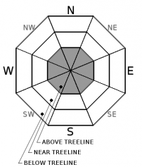
-
Likelihood ?CertainVery LikelyLikelyPossible
 Unlikely
 -
Size ?HistoricVery LargeLargeSmall

With blowing snow visible above 12,000 feet on Mt Shasta yesterday, it is possible that new wind slabs could have formed in isolated areas. Areas such as, but not limited to are near Redbanks, the Trinity Chutes, the east side gullies off of Sargents Ridge/Thumb Rock, and the Hotlum Headwall/Hotlum-Wintun area. All these locations are where steep slopes (>37 degrees) spill off lower angle slopes of the upper mountain. These new, small to medium size wind slabs will be a concern for climbers and intrepid ski mountaineers who venture onto the top half of the mountain. While likely not large avalanches, they certainly could cause one to be swept off their feet and taken for a ride.
Forecast Discussion
The road (Everitt Memorial Hwy) to Bunny Flat (south side trailhead on Mt Shasta) and Castle Lake (west side trailhead) remain unplowed and closed at this time. Access to the backcountry can be made via the Mt Shasta Ski Park to the Gray Butte area or by parking at McBride Springs and heading up the road or Cascade Gulch. Snowmobile access will get you to many areas. The Pilgrim Creek and Deer Mountain snowmobile parks are open and trails are being groomed daily.
Climbing the mountain this weekend? Several days of good weather may lure a few contestants onto the mountain. A winter ascent of Mt Shasta significantly up's the ante. Be prepared, carry a beacon, shovel and probe and know how to use them! Be able to identify avalanche terrain and features of concern. Soft powder snow prevails and skis, splitboard or snowshoes are essential. Post-holing is guaranteed for those that come without. Lastly, as mentioned, access to the south side routes is limited to McBride Springs, approximately 4 miles up the Everitt Memorial Hwy. This means about 6 miles of snow covered roads OR an alternate route up Cascade Gulch toward Horse Camp. Please call the Mt Shasta Ranger Station for further details. 530-926-4511
Recent Observations
Observations were made and received from out along the east side of Mt Shasta yesterday and Black Butte. Both areas show the most recent storm snow continuing to settle and gain strength. Snowpack tests and informal observations gave no indication of any ongoing instabilities in the snowpack. Wind transport was visible on the upper ramparts of Mt Shasta, elevations above 12,000 feet. This could be a problem for any climbers or ski mountaineers attempting a winter ascent of the mountain this weekend. Winds were dead calm below and near treeline and light above treeline at mid-mountain levels. Black Butte hosts a somewhat shallow snowpack, but enough to ski and ride. Be careful for exposed, rocky vents if you venture up there. Soft powder snow surfaces still prevail for most areas except on some southerly aspects where a 1-2cm sun crust has inconsistently distributed itself.
Weather and Current Conditions
Weather Summary
Mostly clear skies will be the soup de jour today. Low clouds and valley fog will continue for the AM hours but clear out by the afternoon. Winds will be light and variable and daytime high temperatures are bumping up a few degrees each day this weekend. Expect chilly nights and cool mornings however. What is the weather going to be like this weekend? Well, in one word...gorgeous!
===========================================================
In Mt Shasta City at 0500, we have a current temperature of 23 F, three degrees cooler than yesterday at this time, with clear skies.
On Mt Shasta (South Side) in the last 24 hours...
Old Ski Bowl - 7,600ft. the current temperature is 23 degrees F. Temperatures have ranged from 15 F to 29 F. Snow on the ground measures 147 inches with no new snow and 5 inches of settlement.
Grey Butte - 8,000 feet, the current temperature is 19 degrees F. Temperatures have ranged from 16 F to 31 F. Winds have averaged 5 mph with gusts to 21 mph, primarily out of the southeast.
Mt Eddy Range (West side of Interstate-5)...
Castle Lake - 5,600 feet, the current temperature is 23 degrees F. Temperatures have ranged from 21 F to 30 F. Snow on the ground totals 99 inches with no new snow and 1 inch of settlement.
Mt Eddy - 6,500 feet, the current temperature is 18 degrees F. Temperatures have ranged from 14 F to 29 F. Snow on the ground measures 84 inches with no new snow and 2 inches of settlement. Winds have averaged 2-3 mph with gusts to 11 mph, blowing south/southwest.
THIS SEASON PRECIPITATION for MT SHASTA CITY: Since October 1st (the wet season), we have received 32.26 inches of water, normal is 21.22 inches, putting us at 152% of normal. For the month of January and for the year of 2017, we received 11.10 inches of water, normal is 6.01 inches, putting us at 184% of normal.
Always check the weather before you attempt to climb Mt Shasta. Further, monitor the weather as you climb. Becoming caught on the mountain in any type of weather can compromise life and limb. Be prepared.
| 0600 temperature: | 15 |
| Max. temperature in the last 24 hours: | 31 |
| Average wind direction during the last 24 hours: | Southeast |
| Average wind speed during the last 24 hours: | 0-5 mi/hr |
| Maximum wind gust in the last 24 hours: | 5-10 mi/hr |
| New snowfall in the last 24 hours: | 0 inches |
| Total snow depth: | 98 inches |
Two Day Mountain Weather Forecast
Produced in partnership with the Medford NWS
| For 7000 ft to 9000 ft | |||
|---|---|---|---|
|
Friday (4 a.m. to 10 p.m.) |
Friday Night (10 p.m. to 4 a.m.) |
Saturday (4 a.m. to 10 p.m.) |
|
| Weather | Sunny | Mostly clear | Sunny |
| Temperature (°F) | 40 | 26 | 43 |
| Wind (mi/hr) | Northeast 0-5 mph | East/Northeast 0-5 mph | East/Northeast 0-5 mph |
| Precipitation SWE / Snowfall (in) | / 0 | / 0 | / 0 |
| For 9000 ft to 11000 ft | |||
| Friday | Friday Night | Saturday | |
| Weather | Sunny | Mostly clear | Sunny |
| Temperature (°F) | 26 | 26 | 31 |
| Wind (mi/hr) | West/Northwest 10-15 mph | North, becoming south/southeast in the evening 0 | North/Northwest 10-15 mph |
| Precipitation SWE / Snowfall (in) | / 0 | / 0 | / 0 |

