

You are here
Avalanche Advisory for 2017-01-30 05:42:11
- EXPIRED ON January 31, 2017 @ 5:42 amPublished on January 30, 2017 @ 5:42 am
- Issued by Andrew Kiefer - Mt Shasta Avalanche Center
Bottom Line
MODERATE avalanche danger continues above treeline, primarily in terrain above 10,000ft and on wind loaded slopes steeper than 35 degrees. LOW avalanche danger exists for all aspects near treeline and below treeline. Snow is available for transport, and fresh wind slabs may build today. With sunny skies and warm temperatures expected, be on the lookout for falling rime ice as well as possible wet loose snow surface instabilities.


Avalanche Problem 1: Wind Slab
-
Character ?

-
Aspect/Elevation ?
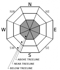
-
Likelihood ?CertainVery LikelyLikelyPossible
 Unlikely
 -
Size ?HistoricVery LargeLargeSmall

Old wind slabs and newly forming wind slabs have the potential to exist on all aspects above treeline, primarily above the 10,000ft level on Mount Shasta. Recent information gathered suggests that old wind slabs are very hard to trigger, and newly forming wind slabs pose the most significant concern at this time. Unsupported, convex, and rocky slopes steeper than 35 degrees in the alpine are the most likely areas to trigger a wind slab in these conditions. Snow is available for transport at all elevations and aspects. Southerly and westerly winds at upper elevations are expected to increase to favorable speeds for transporting snow today.
Forecast Discussion
The road (Everitt Memorial Hwy) to Bunny Flat (south side trailhead on Mt Shasta) and Castle Lake (west side trailhead) remain unplowed and closed at this time. Access to the backcountry can be made via the Mt Shasta Ski Park to the Gray Butte area or by parking at McBride Springs and heading up the road or Cascade Gulch. Snowmobile access will get you to many areas. The Pilgrim Creek and Deer Mountain snowmobile parks are open and trails are being groomed daily.
Soft snow conditions may lure backcountry travelers into complex avalanche terrain in upper elevations. Make sure to prioritize snow stability assessment today. Use visual observations to identify areas of loaded snow, and avoid slopes steeper than 35 degrees where evidence of the wind slab problem exists. With warm temperatures overnight and today, also be on the lookout for wet loose instabilities. If you are heading into the backcountry, always carry a beacon, shovel, and probe and know how to use them. As mentioned, access to the south side routes is limited to McBride Springs, approximately 4 miles up the Everitt Memorial Hwy. This means about 7 miles of snow covered roads OR an alternate route up Cascade Gulch toward Horse Camp.
Recent Observations
Strong temperature inversions continue. This morning, several of our remote weather stations reported temperatures 40 F and warmer with continuous non-freezing temperatures for the past 24 hours. Mount Shasta City and lower elevation weather stations reported temperatures in the mid to high 20’s F.
A visit to the Ash Creek Butte Ridge weather station, and surrounding area, revealed the same right side up snowpack configuration found recently throughout most places within the advisory area. Very good stability was observed yesterday. A few, old avalanches were visible. See photo in Observations below of one large old avalanche on the NE face of Ash Creek Butte. The avalanche ran during our most recent storm cycle. The crown looked to have been up to 3ft deep, but the bed surface had filled in with snow, and it was difficult to determine the exact dimensions of the old avalanche. Snow surfaces on northerly, shady aspects remain cold and dry, despite recent warm temperatures. Solar aspects hold variable, and sun-affected snow surfaces. Wind-affected snow exists near ridgetop, but was not widespread. Very little wind loaded snow was observed in the area yesterday. That being said, plenty of snow is available for transport, and with productive winds, new wind slabs could easily develop.
Weather and Current Conditions
Weather Summary
Mostly sunny weather is expected again today, with high temperatures in the mountains in the low 50’s F. At the 8000ft level and below, light and variable winds will continue. Upper elevations will see increasing moderate to strong westerly winds. Tomorrow evening and Wednesday look to bring a transition to unsettled weather. Temperatures will gradually cool, with freezing levels dropping to 5000ft by Tuesday night. Heavy snowfall is likely to affect the advisory area on Thursday and Friday.
===========================================================
In Mt Shasta City at 0500, we have a current temperature of 26 F with clear skies.
On Mt Shasta (South Side) in the last 24 hours...
Old Ski Bowl - 7,600ft. the current temperature is 40 degrees F. Temperatures have ranged from 37 F to 51 F. Snow on the ground measures 144 inches with no new snow and 2 inches of settlement.
Grey Butte - 8,000 feet, the current temperature is 41 degrees F. Temperatures have ranged from 39 F to 49 F. Winds have averaged 10-15 mph with gusts to 21 mph, blowing west/northwest.
Mt Eddy Range (West side of Interstate-5)...
Castle Lake - 5,600 feet, the current temperature is 42 degrees F. Temperatures have ranged from 37 F to 50 F. Snow on the ground totals 95 inches with no new snow and little settlement.
Mt Eddy - 6,500 feet, the current temperature is 34 degrees F. Temperatures have ranged from 33 F to 50 F. Snow on the ground measures 78 inches with no new snow and 2 inches of settlement. Winds have averaged 1-5 mph with gusts to 7 mph, blowing west/southwest.
THIS SEASON PRECIPITATION for MT SHASTA CITY: Since October 1st (the wet season), we have received 32.26 inches of water, normal is 21.85 inches, putting us at 147% of normal. For the month of January and for the year of 2017, we received 11.10 inches of water, normal is 6.64 inches, putting us at 167% of normal.
Always check the weather before you attempt to climb Mt Shasta. Further, monitor the weather as you climb. Becoming caught on the mountain in any type of weather can compromise life and limb. Be prepared.
| 0600 temperature: | 25 |
| Max. temperature in the last 24 hours: | 38 |
| Average wind direction during the last 24 hours: | west/northwest |
| Average wind speed during the last 24 hours: | 0-5 mi/hr |
| Maximum wind gust in the last 24 hours: | 10 mi/hr |
| New snowfall in the last 24 hours: | 0 inches |
| Total snow depth: | 92 inches |
Two Day Mountain Weather Forecast
Produced in partnership with the Medford NWS
| For 7000 ft to 9000 ft | |||
|---|---|---|---|
|
Monday (4 a.m. to 10 p.m.) |
Monday Night (10 p.m. to 4 a.m.) |
Tuesday (4 a.m. to 10 p.m.) |
|
| Weather | Mostly sunny | Partly cloudy | Partly sunny, then slight chance of snow. Chance of precipitation is 10% after 4pm. |
| Temperature (°F) | 48 | 26 | 43 |
| Wind (mi/hr) | East/Northeast becoming South in the afternoon 10 mph | South 10-15 mph | South 14-18 mph |
| Precipitation SWE / Snowfall (in) | / 0 | / 0 | / 0 |
| For 9000 ft to 11000 ft | |||
| Monday | Monday Night | Tuesday | |
| Weather | Mostly sunny. Windy. | Mostly cloudy. Windy. | Windy. Mostly cloudy then slight chance of snow. Chance of precipitation is 10% after 4pm |
| Temperature (°F) | 34 | 27 | 33 |
| Wind (mi/hr) | West 32-36 mph | West/Southwest 0 | West 60-70 mph |
| Precipitation SWE / Snowfall (in) | / 0 | / 0 | / 0 |

