

You are here
Avalanche Advisory for 2017-01-31 06:17:58
- EXPIRED ON February 1, 2017 @ 6:17 amPublished on January 31, 2017 @ 6:17 am
- Issued by Andrew Kiefer - Mt Shasta Avalanche Center
Bottom Line
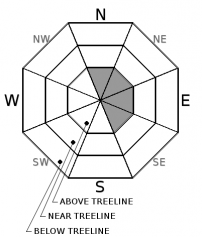
MODERATE avalanche danger exists above treeline on N, NE, E, and SE aspects. Wind loaded slopes steeper than 35 degrees in alpine terrain are the areas where a wind slab problem poses a concern for backcountry travelers. Small human-triggered avalanches remain possible in these specific areas today. Natural avalanches are unlikely. LOW avalanche danger exists for all aspects near treeline and below treeline.


Avalanche Problem 1: Wind Slab
-
Character ?

-
Aspect/Elevation ?
-
Likelihood ?CertainVery LikelyLikelyPossible
 Unlikely
 -
Size ?HistoricVery LargeLargeSmall

Newly forming wind slabs have the potential to exist above treeline on N, NE, E, and SE aspects. Unsupported, convex, and rocky slopes steeper than 35 degrees in the alpine are the most likely areas for a person to trigger a wind slab in these conditions. Snow is available for transport, and southwest winds will remain steady today. Use visual observations to identify areas of loaded snow, and avoid slopes steeper than 35 degrees where evidence of the wind slab problem exists.
Forecast Discussion
The road (Everitt Memorial Hwy) to Bunny Flat (south side trailhead on Mt Shasta) and Castle Lake (west side trailhead) remain unplowed and closed at this time. It may be several days still before either road opens. Access to the backcountry can be made via the Mt Shasta Ski Park to the Gray Butte area or by parking at McBride Springs and heading up the road or Cascade Gulch. Snowmobile access will get you to many areas. The Pilgrim Creek and Deer Mountain snowmobile parks are open and trails are being groomed daily.
Evaluate snow and terrain carefully today, and identify features of concern. The wind slab problem exists on leeward slopes above treeline, primarily in terrain 10,000ft and higher and on slopes 35 degrees and steeper. A wind slab avalanche in these conditions would likely be small, but taking a ride in the terrain where wind slabs exist right now would have high consequences.
Recent Observations
Almost all of our remote weather stations reflect 4 consecutive days of above freezing temperatures. The strong temperature inversion in place during this time is now weakening, and looks to be on its way out.
Overall, snowpack stability is very good throughout the advisory area. Recent reports and information gathered from the south side of Mount Shasta, Ash Creek Butte, Mount Eddy, and the Castle Lake area all confirm similar structure and stability. 6500ft and above, the snowpack is consistently 2-3m deep and presents a strong and right side up configuration. It has been over a week since any significant avalanche activity has occurred.
The recent warm temperatures have affected the snowpack. Snow surfaces are variable, and several inches of snowpack settlement has occurred in the past few days. Some shady-slopes still hold cold and dry snow, but many have experienced surface melting by sun and/or temperature.
Weather and Current Conditions
Weather Summary
Warm weather will continue today with highs in the mid 40’s to low 50’s. Mid and high level clouds will move over the advisory area. Southwest winds will ramp up above 8000ft and remain steady for the next few days. Tomorrow looks to bring similar conditions as to today. Tomorrow night, a pattern shift will occur, and wet and active weather is expected. Precipitation will begin around midnight on Wednesday and last through the weekend. Heavy snowfall is expected on Thursday and Friday. By Saturday, we are set to receive over 2 inches of water. Freezing levels will be fluctuating, and the advisory area will likely see a mix of rain and snow.
===========================================================
In Mt Shasta City at 0500, we have a current temperature of 33 F.
On Mt Shasta (South Side) in the last 24 hours...
Old Ski Bowl - 7,600ft. the current temperature is 36 degrees F. Temperatures have ranged from 34 F to 51 F. Snow on the ground measures 143 inches with no new snow and 1 inch of settlement.
Grey Butte - 8,000 feet, the current temperature is 36 degrees F. Temperatures have ranged from 36 F to 50 F. Winds have averaged 10-20 mph with gusts to 28 mph, blowing out of the west/northwest.
Mt Eddy Range (West side of Interstate-5)...
Castle Lake - 5,600 feet, the current temperature is 40 degrees F. Temperatures have ranged from 39 F to 57 F. Snow on the ground totals 91 inches with no new snow and 4 inches of settlement.
Mt Eddy - 6,500 feet, the current temperature is 40 degrees F. Temperatures have ranged from 33 F to 53 F. Snow on the ground measures 77 inches with no new snow and 1 inch of settlement. Winds have averaged 1-5 mph with gusts to 7 mph, blowing out of the west/southwest.
THIS SEASON PRECIPITATION for MT SHASTA CITY: Since October 1st (the wet season), we have received 32.26 inches of water, normal is 22.06 inches, putting us at 146% of normal. For the month of January and for the year of 2017, we received 11.10 inches of water, normal is 6.85 inches, putting us at 162% of normal.
Always check the weather before you attempt to climb Mt Shasta. Further, monitor the weather as you climb. Becoming caught on the mountain in any type of weather can compromise life and limb. Be prepared.
| 0600 temperature: | 32 |
| Max. temperature in the last 24 hours: | 46 |
| Average wind direction during the last 24 hours: | west/northwest |
| Average wind speed during the last 24 hours: | 0-5 mi/hr |
| Maximum wind gust in the last 24 hours: | 10 mi/hr |
| New snowfall in the last 24 hours: | 0 inches |
| Total snow depth: | 90 inches |
Two Day Mountain Weather Forecast
Produced in partnership with the Medford NWS
| For 7000 ft to 9000 ft | |||
|---|---|---|---|
|
Tuesday (4 a.m. to 10 p.m.) |
Tuesday Night (10 p.m. to 4 a.m.) |
Wednesday (4 a.m. to 10 p.m.) |
|
| Weather | Mostly Cloudy | Mostly Cloudy | Mostly cloudy, then slight chance of snow. Chance of precipitation is 30% after 4pm. |
| Temperature (°F) | 43 | 28 | 38 |
| Wind (mi/hr) | South 21 mph | South/Southeast 15-20 mph, gusting to 30 mph | South 14-17 mph |
| Precipitation SWE / Snowfall (in) | / 0 | / 0 | / .5 |
| For 9000 ft to 11000 ft | |||
| Tuesday | Tuesday Night | Wednesday | |
| Weather | Mostly Cloudy and Windy | Mostly Cloudy and Windy. | Mostly cloudy and windy then slight chance of snow. Chance of precipitation is 10% after 4pm |
| Temperature (°F) | 27 | 25 | 25 |
| Wind (mi/hr) | West/Southwest 60-70 mph | West/Southwest 0 | South/Southwest 25-35 mph |
| Precipitation SWE / Snowfall (in) | / 0 | / 0 | / 0 |

