

You are here
Avalanche Advisory for 2017-02-04 06:16:59
- EXPIRED ON February 5, 2017 @ 6:16 amPublished on February 4, 2017 @ 6:16 am
- Issued by Andrew Kiefer - Mt Shasta Avalanche Center
Bottom Line
Strong winds and blizzard conditions will continue today. Wind slabs pose a significant concern for backcountry travelers near and above treeline on W, NW, N, NE, E, SE aspects. The avalanche danger is CONSIDERABLE above treeline, MODERATE near treeline, and LOW below treeline. Expect increasing avalanche danger with elevation gain, and as additional snow accumulates over the next few days.


Avalanche Problem 1: Wind Slab
-
Character ?

-
Aspect/Elevation ?
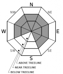
-
Likelihood ?CertainVery LikelyLikelyPossible
 Unlikely
 -
Size ?HistoricVery LargeLargeSmall

Wind slabs are the primary avalanche concern, and can be found near and above treeline on W, NW, N, NE, E, and SE aspects. Wind slabs are already 1-2ft thick, and will build in size and distribution with continued southwesterly winds today. Watch for blowing snow, cornice formation, and newly formed wind pillows to identify areas of loaded snow. Avoid slopes 35 degrees and steeper where evidence of the wind slab problem can be found.
Forecast Discussion
Continued snowfall and strong southwesterly winds will allow for increasing avalanche danger today and throughout the rest of the weekend. Wind slabs pose the most significant concern. This problem exists near and above treeline, and the likelihood of triggering a wind slab increases with elevation gain. Recent rain, and little snow accumulation have not been significant factors to increase the avalanche danger below treeline yet. Loose wet avalanches are possible in these conditions at lower elevations, but likely would not be large enough to pose a threat to backcountry travelers.
Road access is still limited to McBride Springs along the Everitt Memorial Highway, and the Castle Lake road remains unplowed. Riding snowmobiles up on Mt Shasta? It is your responsibility to know the boundaries. Get a map at Bunny Flat or stop by the Mt Shasta Ranger station. Thank you.
Recent Observations
Fluctuating freezing levels have brought mixed precipitation to the advisory area over the past 24 hours. Rain on snow has occurred up to 6000ft, and the snow is wet and heavy up to 6800ft. The old ski bowl weather station, sitting at 7600ft, has received 9 inches of new snow since 02/02. A tour up Grey Butte yesterday revealed the new snow to be heavily wind affected above the 7500ft level. Wind loading and winds slabs were observed on the northeast slopes of Grey Butte. Scoured snow surfaces were found on southerly slopes. No avalanches were observed yesterday. However, where old snow surfaces remained cold and dry on shady upper elevations slopes, the new snow is falling on less dense snow and presents an upside-down configuration. Failures occurred in stability tests just below this interface within fist hard snow about 1ft down from the snow surface on a northeast slope at 7900ft.
Weather and Current Conditions
Weather Summary
An active weather pattern will continue today and through the upcoming week. Strong southwest flow will bring plenty of rain and snow showers to the advisory area with snow levels remaining in the 4000-6000ft range. We are expecting over 1.5 inches of water by the end of the weekend. Blizzard conditions are likely in above treeline terrain on Mount Shasta. Southwest winds are expected to gust to 40 mph at the 6000ft level with much higher gusts at upper elevations. Another low-pressure system will develop off the Pacific Northwest coast tomorrow morning. Along with precipitation, this system will bring increasing strong southerly winds to the Shasta Valley, and extreme winds to terrain 9,000ft and higher.
===========================================================
In Mt Shasta City at 0500, we have a current temperature of 41 F.
On Mt Shasta (South Side) in the last 24 hours...
Old Ski Bowl - 7,600ft. the current temperature is 27 degrees F. Temperatures have ranged from 27 F to 30 F. Snow on the ground measures 150 inches with 4 inches of new snow and little settlement.
Grey Butte - 8,000 feet, the current temperature is 27 degrees F. Temperatures have ranged from 26 F to 29 F. Winds have averaged 15-30 mph with gusts to 56 mph, blowing out of the west/southwest.
Mt Eddy Range (West side of Interstate-5)...
Castle Lake - 5,600 feet, the current temperature is 31 degrees F. Temperatures have ranged from 31 F to 34 F. Snow on the ground totals 90 inches with 4 inches of new snow and 2 inches of settlement due to rain on snow.
Mt Eddy - 6,500 feet, the current temperature is 30 degrees F. Temperatures have ranged from 29 F to 33 F. Snow on the ground measures 79 inches with 3 inches of new snow 2 inches of settlement due to rain on snow. Winds have averaged 1-4 mph with gusts to 17 mph, blowing out of the southwest, south, and southeast.
THIS SEASON PRECIPITATION for MT SHASTA CITY: Since October 1st (the wet season), we have received 33.49 inches of water, normal is 23.0 inches, putting us at 145% of normal. For the month of February, we have received 1.23 inches of water, normal is .73, which is 168% of normal. And finally for the year of 2017, we received 12.33 inches of water, normal is 7.79 inches, putting us at 158% of normal.
Always check the weather before you attempt to climb Mt Shasta. Further, monitor the weather as you climb. Becoming caught on the mountain in any type of weather can compromise life and limb. Be prepared.
| 0600 temperature: | 32 |
| Max. temperature in the last 24 hours: | 33 |
| Average wind direction during the last 24 hours: | SW |
| Average wind speed during the last 24 hours: | 10-15 mi/hr |
| Maximum wind gust in the last 24 hours: | 20 mi/hr |
| New snowfall in the last 24 hours: | 2 inches |
| Total snow depth: | 92 inches |
Two Day Mountain Weather Forecast
Produced in partnership with the Medford NWS
| For 7000 ft to 9000 ft | |||
|---|---|---|---|
|
Saturday (4 a.m. to 10 p.m.) |
Saturday Night (10 p.m. to 4 a.m.) |
Sunday (4 a.m. to 10 p.m.) |
|
| Weather | Snow showers and breezy. Chance of precipitation is 100%. | Snow and breezy. Chance of precipitation is 100%. | Snow and windy. Chance of precipitation is 80%. |
| Temperature (°F) | 36 | 38 | 32 |
| Wind (mi/hr) | South 21-24 mph | South 21-26 mph | South 25-30 mph |
| Precipitation SWE / Snowfall (in) | / 3-7 | / 3-5 | / 2-4 |
| For 9000 ft to 11000 ft | |||
| Saturday | Saturday Night | Sunday | |
| Weather | Heavy snow and windy. Wind chill values as low as -11. Chance of precipitation is 100%. | Snow and windy. Wind chill values as low as -12. Chance of precipitation is 90%. | Snow and windy. Wind chill values as low as -11. Chance of precipitation is 80%. |
| Temperature (°F) | 17 | 16 | 21 |
| Wind (mi/hr) | Southwest 60-65 mph | West/Southwest 9-13 | South/Southwest 65-70 mph |
| Precipitation SWE / Snowfall (in) | / 9-13 | / 5-9 | / 4-8 |

