

You are here
Avalanche Advisory for 2017-02-05 06:24:02
- EXPIRED ON February 6, 2017 @ 6:24 amPublished on February 5, 2017 @ 6:24 am
- Issued by Andrew Kiefer - Mt Shasta Avalanche Center
Bottom Line
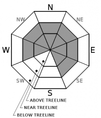
CONSIDERABLE danger exists above treeline and MODERATE danger exists near treeline. Wind slabs are the primary avalanche concern and will continue to build in size and distribution with new snow and strong southwest winds expected during the next 24 hours. The avalanche danger is LOW below treeline.


Avalanche Problem 1: Wind Slab
-
Character ?

-
Aspect/Elevation ?
-
Likelihood ?CertainVery LikelyLikelyPossible
 Unlikely
 -
Size ?HistoricVery LargeLargeSmall

Steady southwest winds have created wind slabs near and above treeline on W, NW, N, NE, E, and SE aspects. Wind slabs may already be 2 feet thick, and will continue to build in size today. The wind slab problem likely poses the greatest concern above treeline on northeasterly aspects. Watch for blowing snow, cornice formation, and newly formed wind pillows to identify areas of loaded snow. Avoid slopes 35 degrees and steeper where evidence of the wind slab problem can be found.
Forecast Discussion
Variable conditions exist in the backcountry, and the avalanche danger significantly increases with elevation gain. Above treeline, plenty of new snow and steady southwest winds have created dangerous avalanche conditions. On wind-loaded slopes 35 degrees and steeper, natural wind slab avalanches are possible, and human triggered wind slab avalanches are likely. Near treeline presents a transition zone where a wind slab problem likely exists, and where backcountry travelers need to be careful in their evaluation of snow and terrain. Rain on snow has been the story below treeline for the past few days, with gradually cooling temperatures last night. The potential for avalanches to occur below treeline remains unlikely. Several inches of new snow are expected today and tonight with continued southwest winds. Increasing avalanche danger is expected tomorrow if the weather forecast verifies.
Recent Observations
Since the recent storm series began on 02/02, freezing levels have remained near 6000ft. Over 1 inch of rain has fallen on snow at and below the freezing level, reducing the height of the snowpack by a few inches at lower elevations. Mixed precipitation and wet heavy snow has fallen up to about 7000ft. The old ski bowl weather station at 7600ft has picked up 13 inches of new snow and over 1.5 inches of water since Thursday. Temperatures have gradually been cooling over the past 12 hours. Poor visibility has limited observations, but there have been no reports of avalanches since the storm series began. Wind transport of new snow is actively occurring. Southwest winds have blown for the past 4 days, loading northerly and easterly aspects. Wind speeds 8000ft and above have averaged about 20mph and greater for the past 2 days. Wind gusts have been very strong to extreme, and very low visibility has been encountered near and above treeline.
Weather and Current Conditions
Weather Summary
Low pressure continues to build off the Pacific Northwest coast, bringing steady southwest flow to northern California. This system is expected to move onshore this evening allowing for the most potent dose of snow precipitation yet from the recent storm series. 1 inch of water is expected during the next 24 hours with freezing levels hovering near 5000ft. Very strong to extreme south and southwest winds will blow. Wet and unsettled weather looks to continue for the majority of the upcoming week.
===========================================================
In Mt Shasta City at 0500, we have a current temperature of 39 F.
On Mt Shasta (South Side) in the last 24 hours...
Old Ski Bowl - 7,600ft. the current temperature is 26 degrees F. Temperatures have ranged from 25 F to 28 F. Snow on the ground measures 154 inches with 4 inches of new snow and little settlement.
Grey Butte - 8,000 feet, the current temperature is 25 degrees F. Temperatures have ranged from 25 F to 27 F. Winds have averaged 15-25 mph with gusts to 49 mph, blowing out of the west/southwest.
Mt Eddy Range (West side of Interstate-5)...
Castle Lake - 5,600 feet, the current temperature is 31 degrees F. Temperatures have ranged from 31 F to 34 F. Snow on the ground totals 88 inches with 1 inch of new snow and 2 inches of settlement due to rain on snow.
Mt Eddy - 6,500 feet, the current temperature is 28 degrees F. Temperatures have ranged from 28 F to 31 F. Snow on the ground measures 82 inches with 3 inches of new snow and little settlement. Winds have averaged 2-3 mph with gusts to 17 mph, blowing out of the south/southeast.
THIS SEASON PRECIPITATION for MT SHASTA CITY: Since October 1st (the wet season), we have received 33.74 inches of water, normal is 23.24 inches, putting us at 145% of normal. For the month of February, we have received 1.48 inches of water, normal is .97, which is 153% of normal. And finally for the year of 2017, we received 12.58 inches of water, normal is 8.03 inches, putting us at 157% of normal.
Always check the weather before you attempt to climb Mt Shasta. Further, monitor the weather as you climb. Becoming caught on the mountain in any type of weather can compromise life and limb. Be prepared.
| 0600 temperature: | 30 |
| Max. temperature in the last 24 hours: | 32 |
| Average wind direction during the last 24 hours: | SW |
| Average wind speed during the last 24 hours: | 10-15 mi/hr |
| Maximum wind gust in the last 24 hours: | 20 mi/hr |
| New snowfall in the last 24 hours: | 2 inches |
| Total snow depth: | 94 inches |
Two Day Mountain Weather Forecast
Produced in partnership with the Medford NWS
| For 7000 ft to 9000 ft | |||
|---|---|---|---|
|
Sunday (4 a.m. to 10 p.m.) |
Sunday Night (10 p.m. to 4 a.m.) |
Monday (4 a.m. to 10 p.m.) |
|
| Weather | Snow showers and windy. Chance of precipitation is 80%. | Heavy snow and windy. Chance of precipitation is 100%. | 100% chance of snow showers before 10am. Breezy. Chance of precipitation reduces to 60% after 10am. |
| Temperature (°F) | 36 | 28 | 30 |
| Wind (mi/hr) | South 23-30 mph, with gusts as high as 45 mph | South/Southwest 31-39 mph | Southwest 22-24 mph |
| Precipitation SWE / Snowfall (in) | / 1-3 | / 10-14 | / 4-8 |
| For 9000 ft to 11000 ft | |||
| Sunday | Sunday Night | Monday | |
| Weather | Snow and windy. Wind chill values as low as -4. Chance of precipitation is 80%. | Heavy snow and windy. Wind chill values as low as -6. Chance of precipitation is 100%. | Windy. Heavy snow, then snow showers likely after 10am. Chance of precipitation 100%, then reduces to 70% after 10am. Wind chill values as low as -12. |
| Temperature (°F) | 22 | 16 | 16 |
| Wind (mi/hr) | South/Southwest 55-60 mph | Southwest 3-5 | West/Southwest 55-60 mph |
| Precipitation SWE / Snowfall (in) | / 3-5 | / 17-23 | / 6-10 |

