

You are here
Avalanche Advisory for 2017-02-06 06:43:19
- EXPIRED ON February 7, 2017 @ 6:43 amPublished on February 6, 2017 @ 6:43 am
- Issued by Andrew Kiefer - Mt Shasta Avalanche Center
Bottom Line
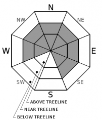
CONSIDERABLE danger exists above treeline and near treeline. The danger is MODERATE below treeline. Over a foot of new snow fell overnight throughout the majority of the advisory area, and strong to extreme southwest winds have continued to blow. Stiff wind slabs and sensitive cornice formations exist in the backcountry and will grow in size and distribution today. Natural avalanches are possible, and human triggered avalanches are likely on wind loaded slopes 35 degrees and steeper.


Avalanche Problem 1: Wind Slab
-
Character ?

-
Aspect/Elevation ?
-
Likelihood ?CertainVery LikelyLikelyPossible
 Unlikely
 -
Size ?HistoricVery LargeLargeSmall

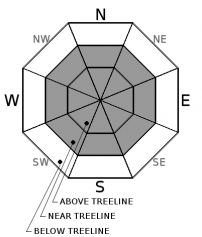
Steady southwest winds have created wind slabs near and above treeline on W, NW, N, NE, E, and SE aspects. Wind slabs may already be 2-3 feet thick, and will continue to build in size today. The wind slab problem is most sensitive on slopes above treeline and on north and east aspects. In many areas, winds are creating very stiff wind slabs that may be stubborn to trigger, but would likely produce a large and dangerous avalanche. Watch for blowing snow, cornice formation, and newly formed wind pillows to identify areas of loaded snow. Avoid slopes 35 degrees and steeper where evidence of the wind slab problem can be found.
Avalanche Problem 2: Cornice
-
Character ?

-
Aspect/Elevation ?
-
Likelihood ?CertainVery LikelyLikelyPossible
Unlikely
-
Size ?HistoricVery LargeLargeSmall
Small to large cornice features exist on many ridgelines throughout the advisory area. Snow accumulation and wind transport are adding weight to existing cornices, and building new cornice features. Cornices are often overhung and can break in very unpredictable ways. If cornices fail, they pose a significant risk of triggering slopes below. Be sure to stand back on ridgelines, and avoid traveling on or below avalanche terrain threatened by cornice hazard.
Forecast Discussion
We are now four days in to a wet a wild storm series. The largest precipitation event so far occurred during the last 12 hours, and the presence of wind slabs and cornices have created dangerous avalanche conditions in the backcountry. Gale force winds, blizzard conditions, and low visibility will continue. Avoid steep (>35 degrees), convex, wind-loaded terrain, and stick to supported slopes with low consequence today. Use visual observations to target investigations of the current avalanche problems. Getting caught in a cornice fall or wind slab avalanche in these conditions would likely have a very bad outcome for anyone involved. Careful snowpack evaluation, cautious route finding, and conservative decision-making are essential today.
Recent Observations
In the past 24 hours, the Old Ski Bowl weather station received 13 inches of new snow and 1.24 inches of water. Since 02/02, 26 inches of new snow have fallen at the 7500ft level and above.
An outing yesterday up Parks Creek road in the Eddy Range revealed gale force winds above treeline and strong and gusty winds near and below treeline, all out of the south/southwest. No avalanches were observed, however, very large and unstable cornice formations were found. Some cornices were overhung 6-8ft and building (see photos in Observations below). Active wind loading was observed, and heavy, stiff wind slabs exist near and above treeline. The wind slab problem appeared stubborn to trigger in near treeline terrain observed yesterday. Small wind-loaded test slopes did not fail or produce cracking with ski cuts. In many places, the new heavy snow seems to have pasted well to the old snow surface. Overall, the new snow is very moist and supportable with boot penetration up to 20cm, and ski penetration up to 10cm in wind-loaded areas, less elsewhere. 6500ft marked a distinct transition to more wintery conditions. Below 5500ft, precipitation came in the form of rain.
Weather and Current Conditions
Weather Summary
Wet and very windy weather continues today. Freezing levels will remain near 5000ft, and will lower to 4000ft overnight. Intermittent rain and snow will continue during the day, as will strong and gusty southwest winds. A return to steady precipitation will occur this evening as a warm front moves through northern California. 6-12 inches of additional snow are expected overnight at the 6000ft level and above. Freezing levels will rise to the 6000ft-7000ft levels by Tuesday night and Wednesday. Unsettled weather will continue through the end of the week.
===========================================================
In Mt Shasta City at 0500, we have a current temperature of 41 F.
On Mt Shasta (South Side) in the last 24 hours...
Old Ski Bowl - 7,600ft. the current temperature is 27 degrees F. Temperatures have ranged from 24 F to 29 F. Snow on the ground measures 167 inches with 13 inches of new snow and little settlement.
Grey Butte - 8,000 feet, the current temperature is 26 degrees F. Temperatures have ranged from 23 F to 27 F. Wind have averaged 15-25 mph with gusts to 49 mph, blowing out of the west/southwest.
Mt Eddy Range (West side of Interstate-5)...
Castle Lake - 5,600 feet, the current temperature is 31 degrees F. Temperatures have ranged from 30 F to 31 F. Snow on the ground totals 96 inches with 8 inches of new snow and little settlement.
Mt Eddy - 6,500 feet, the current temperature is 29 degrees F. Temperatures have ranged from 26 F to 30 F. Snow on the ground measures 92 inches with 10 inches of new snow and little settlement. Winds have averaged 2-3 mph with gusts to 17 mph, blowing out of the south/southeast.
THIS SEASON PRECIPITATION for MT SHASTA CITY: Since October 1st (the wet season), we have received 34.54 inches of water, normal is 23.48 inches, putting us at 147% of normal. For the month of February, we have received 2.28 inches of water, normal is 1.21, which is 188% of normal. And finally for the year of 2017, we received 13.38 inches of water, normal is 8.27 inches, putting us at 162% of normal.
Always check the weather before you attempt to climb Mt Shasta. Further, monitor the weather as you climb. Becoming caught on the mountain in any type of weather can compromise life and limb. Be prepared.
| 0600 temperature: | 31 |
| Max. temperature in the last 24 hours: | 32 |
| Average wind direction during the last 24 hours: | SW |
| Average wind speed during the last 24 hours: | 10-15 mi/hr |
| Maximum wind gust in the last 24 hours: | 20 mi/hr |
| New snowfall in the last 24 hours: | 8 inches |
| Total snow depth: | 102 inches |
Two Day Mountain Weather Forecast
Produced in partnership with the Medford NWS
| For 7000 ft to 9000 ft | |||
|---|---|---|---|
|
Monday (4 a.m. to 10 p.m.) |
Monday Night (10 p.m. to 4 a.m.) |
Tuesday (4 a.m. to 10 p.m.) |
|
| Weather | Snow showers and breezy. Chance of precipitation is 100%. | Snow showers. Temperature rising to near 30 degrees by 5am. Chance of precipitation is 100%. | Windy. Snow before 4pm, then rain. Chance of precipitation 100%. |
| Temperature (°F) | 31 | 26 | 41 |
| Wind (mi/hr) | Southwest 22-28 mph | South 13-15 mph | South 16-26 mph, increasing to 26-36mph |
| Precipitation SWE / Snowfall (in) | / 4-8 | / 6-10 | / 3-5 |
| For 9000 ft to 11000 ft | |||
| Monday | Monday Night | Tuesday | |
| Weather | Snow and windy. Wind chill values as low as -12. Chance of precipitation is 100%. | Heavy snow and windy. Wind chill values as low as -11. Temperature rising to 30 degrees by 4am Chance of precipitation is 100%. | Windy. Snow mainly before 4pm. Chance of precipitation in the afternoon is 70%. |
| Temperature (°F) | 16 | 16 | 27 |
| Wind (mi/hr) | West/Southwest 60-65 mph | West/Southwest 7-11 | Southwest 39-49 mph |
| Precipitation SWE / Snowfall (in) | / 7-11 | / 11-17 | / 4-8 |

