

You are here
Avalanche Advisory for 2017-02-11 06:58:01
- EXPIRED ON February 12, 2017 @ 6:58 amPublished on February 11, 2017 @ 6:58 am
- Issued by Andrew Kiefer - Mt Shasta Avalanche Center
Bottom Line
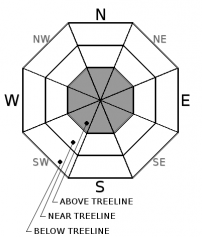
MODERATE avalanche danger exists above treeline. Newly forming winds slabs on all aspects above 8500ft pose the greatest avalanche concern. Human triggered avalanches are possible on wind loaded slopes 35 degrees and steeper. Natural avalanches are unlikely. The avalanche danger is LOW near treeline and below treeline today.


Avalanche Problem 1: Wind Slab
-
Character ?

-
Aspect/Elevation ?
-
Likelihood ?CertainVery LikelyLikelyPossible
 Unlikely
 -
Size ?HistoricVery LargeLargeSmall

The wind slab avalanche problem exists above treeline, and is confined to terrain above 8500ft. The most significant wind slab development exists on east and north aspects. However, variable winds, blowing from all directions of the compass in the past 24 hours, have created the potential for wind slabs to exist on all aspects today. Recent wind loading, and newly forming wind slabs pose the greatest concern. Old wind slabs that formed early in the week are likely very stiff and stubborn to trigger. Avoid slopes 35 degrees and steeper above treeline where evidence of the wind slab problem exists, and be especially cautious of unsupported slopes and convexities.
Forecast Discussion
A transition to clear skies and sunshine will occur today and last for the majority of the upcoming week. Human triggered wind slabs in upper elevation terrain on Mount Shasta pose the greatest avalanche concern. Recent heavy rain followed by cooling temperatures, have created a supportable rain crust and widespread rain runnels up to 8500ft. These factors have created very good stability near and below treeline, but firm and variable skiing and riding conditions exist.
Join us tonight in Ashland, OR at 6:30pm for Avalanche Awareness at the Ashland Outdoor Store, and tomorrow at 9am for an Avalanche Rescue Clinic at the Mt Ashland Beacon Park.
Recent Observations
The Everitt Memorial HWY reopened yesterday morning, and Bunny Flat is back to being a functional trailhead; the bathrooms are open, plenty of parking space is available, and a steep snowmobile ramp exiting the parking lot is in place. A ride from Bunny Flat to the Old Ski Bowl yesterday allowed for a quick fix of the weather station, and all of our remote weather stations are in good working order again.
Variable conditions exist in the backcountry. Dramatic evidence of rain on snow can be found up to 8500ft. Deep rain runnels and a supportable rain crust have created very firm and uneven snow surface conditions throughout terrain near and below treeline. With recent cooling temperatures, the snowpack has locked up in these elevations bands, and no signs of instability were observed yesterday. Skiers who ventured up Green Butte Ridge reported the transition to dry snow to be near 8700ft. At and above this elevation, recent southwest winds have significantly affected the snow. Snow surfaces remained firm with 1-2 inches of ski penetration. Evidence of old, and unreactive wind deposits were observed.
Weather and Current Conditions
Weather Summary
The rain and snow have ended for now, and dry weather is expected. Northwest flow will allow for a ridge of high pressure to build, and skies will clear throughout the day. At the 6000ft level, high temperatures should reach the mid 40’s and northerly winds will remain light. The ridge of high pressure will be in place throughout the week, and sunny skies and warming temperatures will continue. Strong temperatures inversions are also expected during this time. Confidence is high that wet, stormy weather will return by the end of the week.
===========================================================
In Mt Shasta City at 0500, we have a current temperature of 33 F with mostly cloudy skies.
On Mt Shasta (South Side) in the last 24 hours...
Old Ski Bowl - 7,600ft. the current temperture is 19 degrees F. Temperatures have ranged from 17 F to 27 F. Snow on the ground totals 163 inches with a trace of new snowfall and 1 inch of settlement.
Grey Butte - 8,000 feet, the current temperature is 18 degrees F. Temperatures have ranged from 18 F to 25 F. Winds have averaged 10-20 mph with gusts to 28 mph, blowing primarily out of the west, but varible overnight out of the ENE, NW, SW, and SSE.
Mt Eddy Range (West side of Interstate-5)...
Castle Lake - 5,800 feet, the current temperature is 22 degrees F. Temperatures have ranged from 22 F to 39 F. Snow on the ground totals 86 inches with 1 inch of new snow and 1 inch of settlement.
Mt Eddy - 6,500 feet, the current temperature is 22 degrees F. Temperatures have ranged from 21 F to 32 F. Snow on the ground measures 82 inches with no new snow and little settlement. Winds have averaged 1-3 mph with gusts to 12 mph, blowing southeast to southwest.
THIS SEASON PRECIPITATION for MT SHASTA CITY: Since October 1st (the wet season), we have received 39.04 inches of water, normal is 24.69 inches, putting us at 158% of normal. For the month of February, we have received 6.78 inches of water, normal is 2.42, which is 280% of normal. And finally for the year of 2017, we received 17.88 inches of water, normal is 9.48 inches, putting us at 187% of normal.
Always check the weather before you attempt to climb Mt Shasta. Further, monitor the weather as you climb. Becoming caught on the mountain in any type of weather can compromise life and limb. Be prepared.
| 0600 temperature: | 18 |
| Max. temperature in the last 24 hours: | 32 |
| Average wind direction during the last 24 hours: | West |
| Average wind speed during the last 24 hours: | 5-10 mi/hr |
| Maximum wind gust in the last 24 hours: | 25 mi/hr |
| New snowfall in the last 24 hours: | Trace inches |
| Total snow depth: | 96 inches |
Two Day Mountain Weather Forecast
Produced in partnership with the Medford NWS
| For 7000 ft to 9000 ft | |||
|---|---|---|---|
|
Saturday (4 a.m. to 10 p.m.) |
Saturday Night (10 p.m. to 4 a.m.) |
Sunday (4 a.m. to 10 p.m.) |
|
| Weather | Mostly sunny | Mostly clear | Sunny |
| Temperature (°F) | 38 | 27 | 47 |
| Wind (mi/hr) | North/Northeast 9 mph | East/Northeast 7 mph | East/Northeast 7 mph |
| Precipitation SWE / Snowfall (in) | / 0 | / 0 | / 0 |
| For 9000 ft to 11000 ft | |||
| Saturday | Saturday Night | Sunday | |
| Weather | Mostly sunny and windy. Wind chill values as low as -6. | Mostly clear and blustery | Sunny |
| Temperature (°F) | 24 | 24 | 33 |
| Wind (mi/hr) | North/Northeast 24-31 mph | Northeast 0 | Northeast 16-22 mph |
| Precipitation SWE / Snowfall (in) | / 0 | / 0 | / 0 |

