

You are here
Avalanche Advisory for 2017-02-16 06:46:50
- EXPIRED ON February 17, 2017 @ 6:46 amPublished on February 16, 2017 @ 6:46 am
- Issued by Nick Meyers - Shasta-Trinity National Forest
Bottom Line
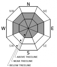
In mid and upper elevation, wind exposed terrain, expect MODERATE danger on steep slopes that have recent deposits of wind drifted snow.
Leeward NW-N-NE aspects and some cross-loaded W and E aspects, steeper than 35 degrees, have the best potential for new wind slabs available for human trigger.
Below treeline, the avalanche danger is generally LOW.


Avalanche Problem 1: Wind Slab
-
Character ?

-
Aspect/Elevation ?
-
Likelihood ?CertainVery LikelyLikelyPossible
 Unlikely
 -
Size ?HistoricVery LargeLargeSmall

Watch for fresh and reactive wind slabs near treeline and primarily above treeline. Be cautious as you transition into wind affected terrain. Avoid open slopes or convex rollovers. Southerly wind will continue to transport snow today onto leeward aspects. Look for signs of instability such as cracking in the snow surface, and avoid areas with recent deposits of wind drifted snow on the leeward sides of ridge crests and terrain features.
Forecast Discussion
Overnight, about 3-5 inches of new snow fell. Wind data has shown strong upper level winds out of the south/southwest. There is some uncertainty regarding the reactivity and distribution of new wind slabs throughout the region due to the new snow/wind occuring overnight. This morning, I'd be cautious for wind slabs before committing to any steeper terrain. An overall stiff and consolodated snowpack exists beneath the new snow with no existing weaknesses. Below treeline, moist snow surfaces from wet snow and/or rain on snow will prevail. Potentially some isolated loose wet activity is possible on steeper slopes below treeline, but not likely to cause trouble for backcountry riders and gliders.
Recent Observations
Yesterday, mostly cloudy skies with periods of light rain fell on Mt Shasta City. Temperatures and snow levels remained high until about midnight last night. The bulk of the precipitation (.62" SWE, Snow Water Equivalent) has fallen since 1am with the Old Ski Bowl recording 5 inches of new snow. All other weather stations received only a trace of new snow and some rain on snow. Very windy conditions have prevailed. South to southest winds have been howling and while wind speeds will diminish a bit today, they certainly are not going away. New and notable observations from yesterday were few. Uniform and smooth snow surfaces above 8,400 feet have greeted the new snow from last night. Overall a firm and consolidated snowpack exists up to 9,500 feet. Some areas hosted a thin ice lens prior to this storm.
Weather and Current Conditions
Weather Summary
The front that has brought us overnight rain and high elevation snow is a little behind schedule which will mean continued wet and windy weather into the late morning hours. Precipitation and wind will taper off later today and become showery into Friday. Don't get your sun hat out yet because the entire weekend will provide unsettled weather. Winds have been primarily blowing out of the southwest. Expect an overnight shift from southwest to southeast and eventually easterly at lower elevations. The wind will diminish some but it is still expected to be a windy couple days. Snow levels are forecast for 5,700 feet today, 5,000 feet tonight and 4,500 feet tomorrow. We shouldn't see the snow level drop much below that. Temperatures will remain steady for the near future. While a few lulls will occur, this weekend will provide no relief from rain, snow and wind. Another significant storm will push through on Saturday and Sunday.
===========================================================
In Mt Shasta City at 0500, we have a current temperature of 37 F with light rain falling.
On Mt Shasta (South Side) in the last 24 hours...
Old Ski Bowl - 7,600ft. the current temperture is 25 degrees F. Temperatures have ranged from 25 F to 34 F. Snow on the ground totals 161 inches with 5 inches of new snow (.60 SWE).
Grey Butte - 8,000 feet, the current temperature is 24 degrees F. Temperatures have ranged from 24 F to 32 F. Winds have averaged 15-20 mph with gusts to 49 mph, blowing south/southwest and then switching to southeast early this morning..
Mt Eddy Range (West side of Interstate-5)...
Castle Lake - 5,800 feet, the current temperature is 29 degrees F. Temperatures have ranged from 29 F to 38 F. Snow on the ground totals 81 inches with no new snow.
Mt Eddy - 6,500 feet, the current temperature is 28 degrees F. Temperatures have ranged from 27 F to 37 F. Snow on the ground measures 78 inches with no new snow. Winds have averaged 3 mph with gusts to 22 mph, blowing south/southwest.
THIS SEASON PRECIPITATION for MT SHASTA CITY: Since October 1st (the wet season), we have received 39.28 inches of water, normal is 25.93 inches, putting us at 151% of normal. For the month of February, we have received 7.02 inches of water, normal is 3.66, which is 191% of normal. And finally for the year of 2017, we received 18.12 inches of water, normal is 10.72 inches, putting us at 169% of normal.
Always check the weather before you attempt to climb Mt Shasta. Further, monitor the weather as you climb. Becoming caught on the mountain in any type of weather can compromise life and limb. Be prepared.
| 0600 temperature: | 38 |
| Max. temperature in the last 24 hours: | 50 |
| Average wind direction during the last 24 hours: | SE to SW |
| Average wind speed during the last 24 hours: | 5-10 mi/hr |
| Maximum wind gust in the last 24 hours: | 15 mi/hr |
| New snowfall in the last 24 hours: | 0 inches |
| Total snow depth: | 92 inches |
Two Day Mountain Weather Forecast
Produced in partnership with the Medford NWS
| For 7000 ft to 9000 ft | |||
|---|---|---|---|
|
Thursday (4 a.m. to 10 p.m.) |
Thursday Night (10 p.m. to 4 a.m.) |
Friday (4 a.m. to 10 p.m.) |
|
| Weather | Snow before 10am, then snow showers, mainly after 10am. The snow could be heavy at times. Some thunder is also possible. Breezy. Chance of precipitation is 100%. | Snow showers likely, mainly before 10pm. Cloudy. Chance of precipitation is 70%. | Snow showers likely, mainly after 10am. Cloudy. Chance of precipitation is 60%. |
| Temperature (°F) | 35 | 27 | 35 |
| Wind (mi/hr) | South/Southwest 20-25 mph | South switching to southeast/east 10-15 mph | East/Northeast 10-15 mph |
| Precipitation SWE / Snowfall (in) | / 4-6 | / 1-3 | / 1-3 |
| For 9000 ft to 11000 ft | |||
| Thursday | Thursday Night | Friday | |
| Weather | Snow before 10am, then snow showers, mainly after 10am. The snow could be heavy at times. Temperature falling to around 12 by 11am. Windy. Wind chill values as low as -17. Chance of precipitation is 100%. | Snow showers likely, mainly before 10pm. Cloudy. Windy. Wind chill values as low as -14. Chance of precipitation is 70%. | Snow showers likely, mainly after 10am. Cloudy. Windy. Wind chill values as low as -8. Chance of precipitation is 60%. |
| Temperature (°F) | 12 | 14 | 21 |
| Wind (mi/hr) | Southwest 45-50 mph | South/Southwest 5-10 | South/Southeast 25-30 mph |
| Precipitation SWE / Snowfall (in) | / 5-10 | / 1-3 | / 2-4 |

