

You are here
Avalanche Advisory for 2017-02-17 07:00:00
- EXPIRED ON February 18, 2017 @ 7:00 amPublished on February 17, 2017 @ 7:00 am
- Issued by Nick Meyers - Shasta-Trinity National Forest
Bottom Line
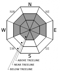
Near treeline and above treeline, MODERATE avalanche danger will exist for wind slabs that have formed over the past 36 hours. Isolated slabs up to 2 feet thick will exist on primarily W-NW-N facing aspects.
Also, avoid fresh cornice formations along ridgelines and near the tops of bowls.
Storm slabs may exist in sheltered areas near and below treeline on all aspects but unlikely to be triggered.
Below treeline, the overall danger is LOW.


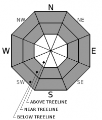
Avalanche Problem 1: Wind Slab
-
Character ?

-
Aspect/Elevation ?
-
Likelihood ?CertainVery LikelyLikelyPossible
 Unlikely
 -
Size ?HistoricVery LargeLargeSmall

Fresh snow and moderate to strong SW-S-SE winds have created wind slabs in alpine and open terrain near treeline. Natural avalanches are unlikley, however human skier or rider triggered wind slabs are possible on slopes steeper than 35 degrees. Be cautious as you transition into wind affected terrain. Open slopes or convex rollovers should be observed and evaluated carefully. Look for signs of instability such as cracking in the snow surface, and avoid areas with recent deposits of wind drifted snow on the leeward sides of ridge crests and terrain features.
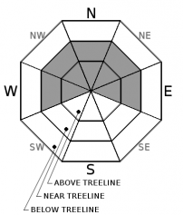
Avalanche Problem 2: Storm Slab
-
Character ?

-
Aspect/Elevation ?
-
Likelihood ?CertainVery LikelyLikelyPossible
Unlikely
-
Size ?HistoricVery LargeLargeSmall
Steep, open slopes in sheltered areas below treeline and near treeline will be the best places to find storm slab instabilities today. Natural and human triggering of storm slabs is unlikely, but not impossible.
Avalanche Problem 3: Cornice
-
Character ?

-
Aspect/Elevation ?
-
Likelihood ?CertainVery LikelyLikelyPossible
Unlikely
-
Size ?HistoricVery LargeLargeSmall
Southerly wind and up to a foot of new, wet snow has made for good cornice building characteristics. Watch for unstable cornices along ridgelines and near the tops of bowls. Cornices are most common in the Castle Lake and Mt Eddy areas and some isolated ridgelines on Mt Shasta. Cornices can often trigger wind or storm slabs on slopes below.
Forecast Discussion
While no obvious signs of instability have been noted over the past 36 hours, the onset of our storm, it will still be important to keep your head on a swivel and pay attention out there. With 1 foot of new snow and southerly winds prime for snow transport, isolated areas could host unstable snow...especially as one moves into above treeline terrain. We are often blessed with the classic "Shasta Plaster"... in short, big dumps with relatively little avalanche activity. Don't let this notion cause complacency. Stay on your game, practice safe travel techniques every day, know how to use your rescue equipment like it's second nature and once again, pay attention to mother nature's obvious signs of instability like recent avalanches, wind, new snow, and cracking or collapsing of the snowpack.
Recent Observations
In the past 24 hours, elevations above 6,500 feet have received 10 inches of new snow and a 36 hour storm total of 12-15 inches. Our snow-water equivalent was .91" SWE at the Old Ski Bowl station and 1.18" SWE in Mt Shasta City over the past 24 hours. Winds have trended out of SW-S-SE, averaging 15-20 mph at 8,000 feet (treeline) with gusts 40-50 mph. The temperature trend for this storm has decreased with daytime highs dropping a few degrees over the past couple days. Our field observer took a tour from Bunny Flat up Green Butte Ridge yesterday for observations. The day was overall much more wintery feeling than assumptions made while in Mt Shasta City. Observations made yesterday did not yield any obvious signs of instability. The new snow displayed good bonding characteristics to the old snow. The storm arrived warm and gradually cooled creating a right side up, new snow configuration. A few weaknesses in the new snow at 13cm and 36cm, due to slight density changes, were noted. Full slope propagation is unlikely. Isolated wind loading was observed on W-NW-N aspects with slab depths up to 18 inches. Visibility above treeline was poor. Micro cornice features were observed on the drive up to Bunny Flat and wind transport of new snow was definitely occuring.
Weather and Current Conditions
Weather Summary
We've officially made the shift to a more wintery pattern in the Mt Shasta area. Cooler, wetter and windier weather is likely to persist through next week. For today, a strong low will move east toward San Francisco. This will bring significant precipitation to central and southern California. Northern California will remain secondary as the northern extent of the low will bring gradually increasing probability of light, afternoon rain and snow. Snow levels will sit at about 4,700 to 5,500 feet with a few inches of snow possible. Gradually diminishing showers will result for Saturday with snow levels a bit lower. A short break Saturday evening will ensue before a storm from the west moves in. This storm has more punch, lowering snow levels to 3,000 to 4,000 feet and bringing an additional 2 to 5 inches of snow. Sunday into Monday is most notable as the Central Sierra braces for a whopper. More on the impact of this storm for us later. Overall, rain and snow is in the box for the foreseeable future.
===========================================================
In Mt Shasta City at 0500, we have a current temperature of 37 F.
On Mt Shasta (South Side) in the last 24 hours...
Old Ski Bowl - 7,600ft. the current temperture is 21 degrees F. Temperatures have ranged from 19 F to 27 F. Snow on the ground totals 171 inches with 7 inches of new snow and a 36 hour storm total of 12 inches.
Grey Butte - 8,000 feet, the current temperature is 18 degrees F. Temperatures have ranged from 18 F to 26 F. Winds have averaged 20 mph with gusts to 49 mph, blowing out of the west/southwest.
Mt Eddy Range (West side of Interstate-5)...
Castle Lake - 5,800 feet, the current temperature is 29 degrees F. Temperatures have ranged from 28 F to 33 F. Snow on the ground totals 91 inches with 10 inches of new snow.
Mt Eddy - 6,500 feet, the current temperature is 26 degrees F. Temperatures have ranged from 24 F to 30 F. Snow on the ground measures 90 inches with 12 inches of new snow. Winds have averaged 2 mph with gusts to 16 mph, blowing south/southwest.
THIS SEASON PRECIPITATION for MT SHASTA CITY: Since October 1st (the wet season), we have received 40.46 inches of water, normal is 26.21 inches, putting us at 154% of normal. For the month of February, we have received 8.20 inches of water, normal is 3.94, which is 208% of normal. And finally for the year of 2017, we received 19.30 inches of water, normal is 11.0 inches, putting us at 175% of normal.
Always check the weather before you attempt to climb Mt Shasta. Further, monitor the weather as you climb. Becoming caught on the mountain in any type of weather can compromise life and limb. Be prepared.
| 0600 temperature: | 26 |
| Max. temperature in the last 24 hours: | 33 |
| Average wind direction during the last 24 hours: | W/SW |
| Average wind speed during the last 24 hours: | 5-10 mi/hr |
| Maximum wind gust in the last 24 hours: | 15 mi/hr |
| New snowfall in the last 24 hours: | 10 inches |
| Total snow depth: | 102 inches |
Two Day Mountain Weather Forecast
Produced in partnership with the Medford NWS
| For 7000 ft to 9000 ft | |||
|---|---|---|---|
|
Friday (4 a.m. to 10 p.m.) |
Friday Night (10 p.m. to 4 a.m.) |
Saturday (4 a.m. to 10 p.m.) |
|
| Weather | Snow showers likely. Cloudy. Chance of precipitation is 70%. | Snow showers. Chance of precipitation is 90%. | Snow showers likely, mainly before 10am. Mostly cloudy. Chance of precipitation is 70%. |
| Temperature (°F) | 38 | 30 | 38 |
| Wind (mi/hr) | East 5-10 mph | East 5-10 mph | West 5-10 mph |
| Precipitation SWE / Snowfall (in) | / 2-4 | / 2-4 | / 1-2 |
| For 9000 ft to 11000 ft | |||
| Friday | Friday Night | Saturday | |
| Weather | Snow showers likely. Cloudy. Windy. Wind chill values as low as -4. Chance of precipitation is 70%. | Snow showers. Breezy. Chance of precipitation is 90%. | Snow showers likely, mainly before 10am. Mostly cloudy. Wind chill values as low as -1. Chance of precipitation is 70%. |
| Temperature (°F) | 25 | 20 | 20 |
| Wind (mi/hr) | South 25-30 mph | Southeast 5-7 | Southwest 10-15 mph |
| Precipitation SWE / Snowfall (in) | / 5-7 | / 5-7 | / 1-3 |

