

You are here
Avalanche Advisory for 2017-02-18 07:00:02
- EXPIRED ON February 19, 2017 @ 7:00 amPublished on February 18, 2017 @ 7:00 am
- Issued by Andrew Kiefer - Mt Shasta Avalanche Center
Bottom Line
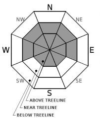
CONSIDERABLE avalanche danger exists near treeline and above treeline. New snow and moderate E-S-W winds have created fresh wind slabs 2-4ft thick. On wind-loaded slopes 35 degrees and steeper, human-triggered avalanches are likely and natural avalanches are possible. The potential exists for cornice fall and storm slab avalanches as well. The avalanche danger below treeline is MODERATE.


Avalanche Problem 1: Wind Slab
-
Character ?

-
Aspect/Elevation ?
-
Likelihood ?CertainVery LikelyLikelyPossible
 Unlikely
 -
Size ?HistoricVery LargeLargeSmall

New snow, and moderate to strong E-SE-S-SW-W winds have created fresh wind slabs near and above treeline. Wind slabs are already 2-4ft thick and continue to build in size and distribution. Wind-loaded slopes 35 degrees and steeper pose the greatest risk for avalanches today. Be cautious as you gain elevation and transition into terrain affected by the wind. Look for obvious signs of instability like recent avalanches and shooting cracks, and avoid slopes 35 degrees and steeper where evidence of the wind slab problem exists.
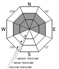
Avalanche Problem 2: Cornice
-
Character ?

-
Aspect/Elevation ?
-
Likelihood ?CertainVery LikelyLikelyPossible
Unlikely
-
Size ?HistoricVery LargeLargeSmall
East, south, and west winds and up to a foot of new snow have allowed cornices to form in exposed areas near and above treeline. Watch for unstable cornices along ridgelines and near the tops of bowls. Cornices are most common in the Castle Lake and Mt Eddy areas and some isolated ridgelines on Mt Shasta. Cornices can often trigger wind or storm slabs on slopes below.
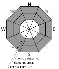
Avalanche Problem 3: Storm Slab
-
Character ?

-
Aspect/Elevation ?
-
Likelihood ?CertainVery LikelyLikelyPossible
Unlikely
-
Size ?HistoricVery LargeLargeSmall
Steep, open slopes below treeline and near treeline will be the best places to find storm slab instabilities today. With 20-25 inches of new snow in the past 48 hours, human triggered storm slab avalanches are possible. Recent observations indicate that storm slabs are stubborn to trigger. Despite this, more snow is on the way, and storm slabs will continue to build in size. Give the snowpack time to adjust to the added weight of the new snow before venturing into complex terrain.
Forecast Discussion
One to two feet of new snow and steady winds over the past 2 days have created dangerous avalanche conditions in the backcountry. A small skier triggered wind slab avalanche occurred yesterday near treeline, and wind slabs continue to pose the greatest avalanche concern. Choose conservative terrain today and stick to moderate angled and supported slopes with low consequence. Ongoing snowfall will keep avalanche danger elevated through the weekend and into next week.
Recent Observations
Since 02/16, areas 6000ft and above have received 20-25 inches of snow and over 2 inches of snow water equivalent. During this time, winds have averaged 15-20 mph blowing out of the E, SE, S, SW, W at the 8000ft level.
Yesterday, observations were gathered on Grey Butte and in the Old Ski Bowl. A small wind slab avalanche was intentionally human triggered on a west-facing slope at 7800ft below the Grey Butte weather station. The crown was 3-5 inches deep and the avalanche ran for 200ft. The avalanche failed on a density break within newly wind deposited snow. Shooting cracks were also observed while skinning through pockets of loaded snow near treeline on Grey Butte.
The wind slab problem was the primary avalanche concern yesterday. Wind slabs were observed 2-4ft thick and building. Evidence of E-S-W winds were widespread near and above treeline. The height of storm snow ranged from 15-20 inches in areas protected from the wind. The storm snow has bonded well to the old snow surface. Stability tests targeting the storm slab problem revealed 2 density breaks within the storm snow. No propagation occurred during large column tests, and resistant planar fractures and non-planar breaks occurred in small column tests.
Weather and Current Conditions
Weather Summary
A series of frontal systems will continue to impact the advisory area through Wednesday. Today, expect rain and snow showers with freezing levels near 5000ft. Precipitation will diminish this afternoon and early evening, as increasing southerly winds develop. Tonight and tomorrow, freezing levels will drop to near 3500ft before rising again on Monday to 5500ft. Tomorrow night through Monday night will bring the greatest dose of precipitation during this storm series. By Wednesday, the advisory area is expecting to pick up at least 3-4 inches of water, which will fall as a mix of rain and snow.
===========================================================
In Mt Shasta City at 0500, we have a current temperature of 35 F.
On Mt Shasta (South Side) in the last 24 hours...
Old Ski Bowl - 7,600ft. the current temperture is 27 degrees F. Temperatures have ranged from 24 F to 28 F. Snow on the ground totals 173 inches with 4 inches of new snow and a 2 day storm total of 20 inches.
Grey Butte - 8,000 feet, the current temperature is 26 degrees F. Temperatures have ranged from 24 F to 26 F. Winds have averaged 15-25 mph with gusts to 49 mph, blowing out of the east/southeast.
Mt Eddy Range (West side of Interstate-5)...
Castle Lake - 5,800 feet, the current temperature is 28 degrees F. Temperatures have ranged from 27 F to 30 F. Snow on the ground totals 101 inches with 10 inches of new snow.
Mt Eddy - 6,500 feet, the current temperature is 28 degrees F. Temperatures have ranged from 27 F to 29 F. Snow on the ground measures 95 inches with 5 inches of new snow. Winds have averaged 2 mph with gusts to 18 mph, blowing southeast and south/southwest.
THIS SEASON PRECIPITATION for MT SHASTA CITY: Since October 1st (the wet season), we have received 40.89 inches of water, normal is 26.49 inches, putting us at 154% of normal. For the month of February, we have received 8.63 inches of water, normal is 4.22, which is 204% of normal. And finally for the year of 2017, we received 19.73 inches of water, normal is 11.28 inches, putting us at 170% of normal.
Always check the weather before you attempt to climb Mt Shasta. Further, monitor the weather as you climb. Becoming caught on the mountain in any type of weather can compromise life and limb. Be prepared.
| 0600 temperature: | 31 |
| Max. temperature in the last 24 hours: | 32 |
| Average wind direction during the last 24 hours: | E/SE |
| Average wind speed during the last 24 hours: | 5-10 mi/hr |
| Maximum wind gust in the last 24 hours: | 15 mi/hr |
| New snowfall in the last 24 hours: | 4 inches |
| Total snow depth: | 106 inches |
Two Day Mountain Weather Forecast
Produced in partnership with the Medford NWS
| For 7000 ft to 9000 ft | |||
|---|---|---|---|
|
Saturday (4 a.m. to 10 p.m.) |
Saturday Night (10 p.m. to 4 a.m.) |
Sunday (4 a.m. to 10 p.m.) |
|
| Weather | Snow showers, mainly before 4pm. Chance of precipitation is 90%, then reducing to to 60%. | Snow after 10pm. Chance of precipitation is 80%. | Snow showers. Chance of precipitation is 80%. |
| Temperature (°F) | 33 | 24 | 30 |
| Wind (mi/hr) | West 9 mph | South 9-14 mph, 19-24 mph after midnight | Southwest 18-20 mph |
| Precipitation SWE / Snowfall (in) | / 1-3 | / 3-7 | / 4-8 |
| For 9000 ft to 11000 ft | |||
| Saturday | Saturday Night | Sunday | |
| Weather | Snow showers, then snow showers likely. Breezy. Wind chill values as low as -1. Chance of precipitation is 90% before 4pm. | Snow showers. Windy. Wind chill values as low as -17. Chance of precipitation is 80%. | Heavy snow and windy. Wind chill values as low as -21. Chance of precipitation is 80%. |
| Temperature (°F) | 18 | 10 | 17 |
| Wind (mi/hr) | West 13-18 mph | Southwest 2-4 | Southwest 55-65 mph |
| Precipitation SWE / Snowfall (in) | / 2-4 | / 4-8 | / 6-10 |

