

You are here
Avalanche Advisory for 2017-02-26 06:09:26
- EXPIRED ON February 27, 2017 @ 6:09 amPublished on February 26, 2017 @ 6:09 am
- Issued by Nick Meyers - Shasta-Trinity National Forest
Bottom Line
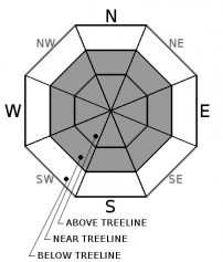
This morning, the avalanche danger remains MODERATE near treeline and above treeline. Avalanche danger could rise to CONSIDERABLE this afternoon as westerly winds increase and load leeward aspects with new and existing, light density snow. Triggering a fresh wind slab is likely late today. Pay attention to blowing snow and note wind direction! Avoid these leeward slopes. Loose dry sloughs on steeper aspects remain possible. Below treeline, the avalanche danger is LOW.


Avalanche Problem 1: Wind Slab
-
Character ?

-
Aspect/Elevation ?
-
Likelihood ?CertainVery LikelyLikelyPossible
 Unlikely
 -
Size ?HistoricVery LargeLargeSmall

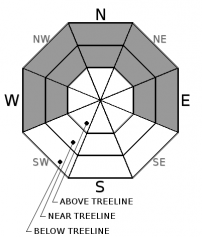
Westerly winds will increase today. Light density snow is available for wind transport. Fresh wind slabs are possible, especially this afternoon, on leeward aspects. Look for blowing snow as an indicator for new wind slab formation.
Avalanche Problem 2: Loose Dry
-
Character ?

-
Aspect/Elevation ?
-
Likelihood ?CertainVery LikelyLikelyPossible
Unlikely
-
Size ?HistoricVery LargeLargeSmall
Expect loose dry instabilities where the coldest and least cohesive snow exists on NW-N-NE-E aspects below and near treeline. It is not expected for these avalanches to be a serious threat but could sweep a rider off their feet and into undesireable terrain.
Forecast Discussion
A winter weather advisory is in effect from 10am this morning to 4am PST Monday. Expect rising avalanche danger today. Concern continues to remain for any new wind transport of our 6-8 inches of light density snow that sits atop of the snowpack. An additional 4-6 inches is expected over the next 24 hours.
Recent Observations
Observations were made in the Eddy range yesterday. Tests and observations in several areas over the day did not reveal any signs of instability. A few inches of settlement has occurred in the snowpack over the past several days and we have not had any recent avalanches reported or observed within the forecast area. Outside the forecast area, near Carter Meadows, we had one report of a skier who was caught in a loose dry avalanche. Not much is known of this incident but the nobody was injured or buried. Winds have been calm and we've seen just a couple inches of new snow over the past 48 hours. Sun exposed aspects below 8,000 feet may have a thin zipper crust. Soft powder snow prevails for shady aspects and most areas. Some ridgelines are scoured and firm. Temperatures remain cold.
Weather and Current Conditions
Weather Summary
Low pressure is moving south along the Washington coast now, and light to moderate precipitation has spread to inland locations. The low is moving at a fast clip, but the upper level energy associated with it will slow some as it nears the forecast area and turns eastward later today, remaining in the vicinity through tonight. We should see about .25 inches of water out of this storm and continued cold temperatures. Snow levels will be generally between 1,000 and 1,500 feet. Winds are going to pick up out of the west with this storm, especially at upper elevations. Winter weather will taper off on Monday with high pressure building over the work week.
===========================================================
In Mt Shasta City at 0500, we have a current temperature of 19 F.
On Mt Shasta (South Side) in the last 24 hours...
Old Ski Bowl - 7,600ft, the current temperture is 8 degrees F. Temperatures have ranged from 5 F to 26 F. Snow on the ground totals 191 inches with no new snow and 2 inches of settlement
Gray Butte - 8,000 feet, the current temperature is 8 degrees F. Temperatures have ranged from 8 F to 23 F. Winds have been variable averaging 8 mph with gusts to 28 mph.
Mt Eddy Range (West side of Interstate-5)...
Castle Lake - 5,800 feet, the current temperature is 15 degrees F. Temperatures have ranged from 14 F to 28 F. Snow on the ground totals 108 inches with no new snow and 1 inch of settlement.
Mt Eddy - 6,500 feet, the current temperature is 9 degrees F. Temperatures have ranged from 7 F to 22 F. Snow on the ground measures 109 inches with no new snow and 3 inches of settlement. Winds have been calm, averaging 3 mph with gusts to 7 mph, blowing WSW.
THIS SEASON PRECIPITATION for MT SHASTA CITY: Since October 1st (the wet season), we have received 43.25 inches of water, normal is 28.69 inches, putting us at 150% of normal. For the month of February, we have received 10.99 inches of water, normal is 6.42, which is 171% of normal. And finally for the year of 2017, we received 22.09 inches of water, normal is 13.48 inches, putting us at 163% of normal.
Always check the weather before you attempt to climb Mt Shasta. Further, monitor the weather as you climb. Becoming caught on the mountain in any type of weather can compromise life and limb. Be prepared.
| 0600 temperature: | 11 |
| Max. temperature in the last 24 hours: | 30 |
| Average wind direction during the last 24 hours: | Variable |
| Average wind speed during the last 24 hours: | 8 mi/hr |
| Maximum wind gust in the last 24 hours: | 12 mi/hr |
| New snowfall in the last 24 hours: | 0 inches |
| Total snow depth: | 120 inches |
Two Day Mountain Weather Forecast
Produced in partnership with the Medford NWS
| For 7000 ft to 9000 ft | |||
|---|---|---|---|
|
Sunday (4 a.m. to 10 p.m.) |
Sunday Night (10 p.m. to 4 a.m.) |
Monday (4 a.m. to 10 p.m.) |
|
| Weather | Snow showers, mainly after 10am. Chance of precipitation is 80%. | Snow showers, mainly before 10pm. Chance of precipitation is 100%. | Snow showers likely, mainly after 4pm. Mostly cloudy. Chance of precipitation is 60%. |
| Temperature (°F) | 24 | 15 | 25 |
| Wind (mi/hr) | South/Southwest 10-15 mph | Southwest 10-15 mph | Southwest 10-15 mph |
| Precipitation SWE / Snowfall (in) | / 2-4 | / 1-3 | / 1-3 |
| For 9000 ft to 11000 ft | |||
| Sunday | Sunday Night | Monday | |
| Weather | Snow showers, mainly after 10am. Windy. Wind chill values as low as -25. Chance of precipitation is 80%. | Snow showers, mainly before 10pm.Windy. Wind chill values as low as -25. Chance of precipitation is 100%. . | A 50 percent chance of snow showers. Mostly cloudy and cold, with a high near 4. Windy. Wind chill values as low as -25. |
| Temperature (°F) | Rising to 11 then falling to around 3 | 1 | 4 |
| Wind (mi/hr) | West/Southwest 20-30 mph | West 2-4 | West 30-40 mph |
| Precipitation SWE / Snowfall (in) | / 2-4 | / 1-3 | / 1-3 |

