

You are here
Avalanche Advisory for 2017-03-03 06:03:34
- EXPIRED ON March 4, 2017 @ 6:03 amPublished on March 3, 2017 @ 6:03 am
- Issued by Nick Meyers - Shasta-Trinity National Forest
Bottom Line
LOW avalanche danger exists for all elevations and aspects today and normal caution is advised.
Expect rising avalanche danger this weekend as a winter storm will impact the area bringing potentially feet of new snow and southwest wind.


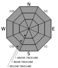
Avalanche Problem 1: Normal Caution
-
Character ?

-
Aspect/Elevation ?
-
Likelihood ?CertainVery LikelyLikelyPossible
 Unlikely
 -
Size ?HistoricVery LargeLargeSmall

Normal caution is advised in the backcountry today. Snow showers are possilbe late today but not expected to cause any snow avalanche concerns. As always: Ski and ride one at a time in avalanche terrain. Don't regroup in avalanche run out zones.
LOW danger does not mean that avalanches are impossible. Continue to identify features of concern and avoid if necessary.
Forecast Discussion
Today will be the last day of LOW avalanche danger. Expect rising avalanche danger as a winter storm begins to impact the area this weekend. Upwards of 1-2 feet of new snow could fall in the mountains with moderate to strong winds out of the southwest. The few that snuck their bikes out during our short stint of beautiful weather will have to stow them for a bit longer!
Recent Observations
Yesterday was Spring-like with temeratures in Mount Shasta City reaching a balmy 63 degrees F. The Castle Lake road is now open and observations were made in this area. A few old wind slab avalanches were visible as were some insignificant loose-wet and loose-dry point releases. (See observation with photos) Overall, we are seeing a stable snowpack within the forecast area with no signs of ongoing instability. Variable snow surfaces prevail. Soft snow can be hunted down...ridgelines remain scoured and firm and breakable crust is likely in sun exposed areas. Bring your full kit of skiing skills.
Weather and Current Conditions
Weather Summary
A wet weather pattern returns to the area beginning tonight. Several storm systems will pass through over the next week. Today we will see increasing clouds as the first front approaches the region tonight. Precipitation will increase over the west side with snow levels around 5,800 feet today and falling tonight. Significant impacts are not likely until the next round of precipitation expected to arrive Saturday afternoon through Sunday night and a winter storm watch is in effect for this time period. Snow levels will drop to around 3,000 feet Saturday evening and then to 1,000 feet by Sunday morning. By the end of the weekend, we could see over 2 inches of water, which could mean several feet of new snow in the high country. Next week will bring continued unsettled weather.
===========================================================
In Mt Shasta City at 0500, we have a current temperature of 29 F.
On Mt Shasta (South Side) in the last 24 hours...
All weather stations are currently down. We apologize and are working to resolve the issue.
THIS SEASON PRECIPITATION for MT SHASTA CITY: Since October 1st (the wet season), we have received 43.31 inches of water, normal is 30.03 inches, putting us at 144% of normal. For the month of March, we have received 0.0 inches of water, normal is .27, which is 0% of normal. And finally for the year of 2017, we received 22.15 inches of water, normal is 14.82 inches, putting us at 149% of normal.
Always check the weather before you attempt to climb Mt Shasta. Further, monitor the weather as you climb. Becoming caught on the mountain in any type of weather can compromise life and limb. Be prepared.
| 0600 temperature: | 23 |
| Max. temperature in the last 24 hours: | 46 |
| Average wind direction during the last 24 hours: | Variable |
| Average wind speed during the last 24 hours: | 0-5 mi/hr |
| Maximum wind gust in the last 24 hours: | 5-10 mi/hr |
| New snowfall in the last 24 hours: | 0 inches |
| Total snow depth: | 112 inches |
Two Day Mountain Weather Forecast
Produced in partnership with the Medford NWS
| For 7000 ft to 9000 ft | |||
|---|---|---|---|
|
Friday (4 a.m. to 10 p.m.) |
Friday Night (10 p.m. to 4 a.m.) |
Saturday (4 a.m. to 10 p.m.) |
|
| Weather | A 30 percent chance of snow, mainly after 4pm. Mostly cloudy. | Snow, mainly after 10pm. Chance of precipitation is 100%. | Snow showers. The snow could be heavy at times. Breezy. Chance of precipitation is 100%. |
| Temperature (°F) | 42 | 31 | 33 |
| Wind (mi/hr) | South/Southwest 10-15 mph | South 15-20 mph | South 20-25 mph |
| Precipitation SWE / Snowfall (in) | / 0-.5 | / 2-4 | / 7-11 |
| For 9000 ft to 11000 ft | |||
| Friday | Friday Night | Saturday | |
| Weather | Snow likely, mainly after 4pm. Mostly cloudy. Windy. Wind chill values as low as -6. Chance of precipitation is 60%. | Snow. Windy. Wind chill values as low as -12. Chance of precipitation is 100%. | Snow showers. The snow could be heavy at times. Windy. Wind chill values as low as -24. Chance of precipitation is 100%. |
| Temperature (°F) | Falling to 19 by 5pm | 12 | Falling to 8 by 3pm |
| Wind (mi/hr) | Southwest 20-25 mph | West/Southwest 0-.5 | Southwest 40-45 mph |
| Precipitation SWE / Snowfall (in) | / 0-.5 | / 3-5 | / 10-15 |

