

You are here
Avalanche Advisory for 2017-03-04 06:40:00
- EXPIRED ON March 5, 2017 @ 6:40 amPublished on March 4, 2017 @ 6:40 am
- Issued by Aaron Beverly - Mount Shasta Avalanche Center
Bottom Line
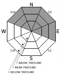
At and above treeline, avalanche danger will increase from LOW to CONSIDERABLE throughout the day as blowing snow produces wind slabs on leewards slopes. CONSIDERABLE means human triggered avalanches are likely and natural avalanches are possible. You will notice the wind today so pay attention to where it is transporting snow and avoid loaded aspects greater than 30 degrees. Avalanche danger below treeline will increase to MODERATE.


Avalanche Problem 1: Wind Slab
-
Character ?

-
Aspect/Elevation ?
-
Likelihood ?CertainVery LikelyLikelyPossible
 Unlikely
 -
Size ?HistoricVery LargeLargeSmall

Avalanche danger due to wind slabs will increase throughout the day if precipitation forecasts verify. With up to 9 inches of light, low density snow predicted today and moderate to strong SW winds below and above treeline, expect plenty of wind transported snow on leeward slopes. Wind slabs may form up to 18-27 inches thick. Loading is expected predominantly on northeastern and eastern aspects but pay attention to all directions! A scoured ridge top is evidence that a wind loaded hill is nearby. Look out for shooting cracks as you travel in safe terrain. These are clear indicators of a wind slab problem and an obvious sign of avalanche danger! When in doubt, stick to pitches under 30 degrees.
Forecast Discussion
No new precipitation has occured overnight meaning avalanche danger will be LOW until snow begins to accumulate later this morning and afternoon. If snow amounts and wind speeds verify, wind slabs will be the primary avalanche problem today. Because predicted storm totals below treeline are 5-7 inches and the snow will likely be low density due to the cold temperatures, storm slabs are not perceived to be an issue, though this may change late tonight and tomorrow as more snow accumulates. Loose sloughs could be a problem in wind protected areas on steep terrain.
From observed temperatures over the last few days, a melt-freeze crust will exist on most aspects below 8500'. This will create an ideal bed surface for wind slabs and loose snow.
Recent Observations
The last three days have seen melt-freeze cycles up to 8500' (and potentionally higher) particularly on sun exposed slopes (east, south, west). Therefore, expect widespread crusts to exist that may provide a smooth bed surface for any slabs or loose snow produced by the next storm.
Weather and Current Conditions
Weather Summary
A winter weather advisory will be in effect from 10 a.m. this morning to 4 p.m. Sunday, with a winter storm watch in effect afterwards until Monday afternoon. With 2 inches of water predicted through Monday afternoon, we could receive up to 2' of snow out of this one. Snow levels are starting slightly high at 3000-4000' this morning but these levels will drop below 1000' by tonight and continue downward to below 500' tomorrow.
If you dare to venture above treeline in the next couple of days, throw some rocks in your pack and bundle up in your puffy, because its going to be cold and windy up there.
===========================================================
In Mt Shasta City at 0500, we have a current temperature of 41 F.
On Mt Shasta (South Side) in the last 24 hours...
Sand Flat - 6750 ft, the current temperture is 28 degrees F. Temperatures have ranged from 23 F to 37 F. Snow on the ground totals 111 inches with no new snow and a 1/2 inch of settlement.
Old Ski Bowl - 7,600ft. This weather station is currently down. We apologize for the inconvenience.
Gray Butte - 8,000 feet, the current temperature is 22 degrees F. Temperatures have ranged from 22 F to 35 F. Winds have been predominantly WNW averaging 16 mph with gusts to 35.
Mt Eddy Range (West side of Interstate-5)...
Castle Lake - 5,800 feet, the current temperature is 29 degrees F. Temperatures have ranged from 29 F to 51 F. Snow on the ground totals 107 with no new snow and 3 inches of settlement.
Mt Eddy - 6,500 feet, the current temperature is 28 degrees F. Temperatures have ranged from 28 F to 45 F. Snow on the ground measures 103 inches with no new snow and 1 inch of settlement. Winds have been calm and variable, averaging 2 mph with gusts up to 10.
THIS SEASON PRECIPITATION for MT SHASTA CITY: Since October 1st (the wet season), we have received 43.32 inches of water, normal is 30.28 inches, putting us at 143% of normal. For the month of March, we have received .01 inches of water, normal is .78, which is 1.3 % of normal. And finally for the year of 2017, we received 22.16 inches of water, normal is 15.07 inches, putting us at 147% of normal.
Always check the weather before you attempt to climb Mt Shasta. Further, monitor the weather as you climb. Becoming caught on the mountain in any type of weather can compromise life and limb. Be prepared.
| 0600 temperature: | 29 |
| Max. temperature in the last 24 hours: | 37 |
| Average wind direction during the last 24 hours: | West Northwest |
| Average wind speed during the last 24 hours: | 16 mi/hr |
| Maximum wind gust in the last 24 hours: | 35 mi/hr |
| New snowfall in the last 24 hours: | 0 inches |
| Total snow depth: | 111 inches |
Two Day Mountain Weather Forecast
Produced in partnership with the Medford NWS
| For 7000 ft to 9000 ft | |||
|---|---|---|---|
|
Saturday (4 a.m. to 10 p.m.) |
Saturday Night (10 p.m. to 4 a.m.) |
Sunday (4 a.m. to 10 p.m.) |
|
| Weather | Snow showers, chance of precipitation 100% | Snow showers, chance of precipitation 100% | Snow showers, chance of precipitation 100% |
| Temperature (°F) | 30-23 | 14 | 24 |
| Wind (mi/hr) | South/Southwest 15-25 mph | Southwest 10-20 mph | Southwest 10-25 mph |
| Precipitation SWE / Snowfall (in) | / 3-7 | / 3-5 | / 4-8 |
| For 9000 ft to 11000 ft | |||
| Saturday | Saturday Night | Sunday | |
| Weather | Snow showers, windy, chance of precipitation 100% | Snow showers, windy, chance of precipitation 100% | Snow showers mainly before 4 pm, chance of precipitation 100% |
| Temperature (°F) | 9 | -3 | -2 |
| Wind (mi/hr) | Southwest 50-60 mph | Southwest 5-9 | West/Southwest changing to West 25-40 mph |
| Precipitation SWE / Snowfall (in) | / 5-9 | / 2-4 | / 3-7 |

