

You are here
Avalanche Advisory for 2017-03-15 06:45:00
- EXPIRED ON March 16, 2017 @ 6:45 amPublished on March 15, 2017 @ 6:45 am
- Issued by Aaron Beverly - Mount Shasta Avalanche Center
Bottom Line
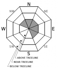
LOW avalanche danger exists on all aspects and at all elevations. This may increase to MODERATE above treeline late in the day as the 2-4 inches of expected snow combine with strong SW winds to create wind slabs. Above 9000', pay attention to where the wind is blowing snow. Avoid leewards aspects greater than 30 degrees. With no overnight freeze and the addition of rain to the snowpack, wet loose avalanches could still pose a problem near and below treeline.


Avalanche Problem 1: Wind Slab
-
Character ?

-
Aspect/Elevation ?
-
Likelihood ?CertainVery LikelyLikelyPossible
 Unlikely
 -
Size ?HistoricVery LargeLargeSmall

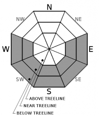
With 2 to 4 inches of snow expected over the next 24 hours at high elevations coupled with strong southwest winds, wind slabs could form on leeward aspects late in the day and tonight. These slabs could be up to 8 inches thick. High elevations have a smooth firm bed surface on which these slabs could slide. If by some chance you find yourself out late in the back country on this wet miserable day and you are above 9,000 feet, pay attention to the wind. A wind slab is a cohesive layer of snow formed when wind deposits snow onto leeward terrain. Wind slabs are often smooth and rounded and sometimes sound hollow. Look for shooting cracks when traveling in safe terrain as indicators of the presence of this avalanche problem.
Avalanche Problem 2: Loose Wet
-
Character ?

-
Aspect/Elevation ?
-
Likelihood ?CertainVery LikelyLikelyPossible
Unlikely
-
Size ?HistoricVery LargeLargeSmall
Continued warm temperatures with no overnight freeze combined with rain today could lead to wet loose avalanches below 9000'. Rain will loosen and add weight to an already soft snow pack. Pay attention to ski and boot penetration. If you are sinking to your boot cuff or further, you should to stay clear of slopes greater than 30 degrees. Slopes will be the softest and most prone to this avalanche problem that have been exposed to the sun over the last few days. This includes E-SE-S-SW-W aspects.
A loose wet avalanche is a release of unconsolidated snow or slush. It starts at a point and entrains snow as it moves downhill. A terrain trap such as a gully, cliff, or an abrupt slope transition can significantly magnify the consequences of being caught in a wet loose avalanche.
Forecast Discussion
Hope you got out yesterday and enjoyed the spectacular corn skiing. It was cooked just right. If you are one that seeks out discomfort as a path to enlightment, rain, low visibility, and wind will provide you with what you are looking for today. If this is not your path, you may want to stay at home.
Recent Observations
A tour up to 10,000' on Tuesday saw the corn snow ripe for harvest on easterly aspects. Conditions for skiing seemed best between 11 a.m. and 1 p.m. A melt-freeze crust 1-2 inches thick was encountered at most elevations atop soft sintered snow. Snow below treeline was soft and sticky in places, though good snow was found on less sun exposed aspects.
Rime ice is caked to exposed rock at high elevations. The Red Banks is fully covered. There does not seem to be any evidence of ice fall yet. No signs of new avalanches were seen either.
Temperatures reached as high as 55 degrees yesterday and never reached freezing over night.
Weather and Current Conditions
Weather Summary
If you are venturing out today in the backcountry, bring your ponchos and galoshes. Expect low visibility, high snow levels, and rain. Snow levels today will hover around 9500 feet, then begin to drop to 6500' by tomorrow. We should see about a quarter of an inch of precipitation throughout today and tonight. This could translate into 2-4 inches of snow up high. Thursday and Friday will see clearer weather followed by more warm and rainy weather into next week.
===========================================================
In Mt Shasta City at 0500, we have a current temperature of 55 F.
On Mt Shasta (South Side) in the last 24 hours...
Sand Flat - 6750 ft, the current temperture is 39 degrees F. Temperatures have ranged from 34 F to 55 F. Snow on the ground totals 103 inches with no new snow and 3 inches of settlement.
Old Ski Bowl - 7,600ft. the current temperature is 37 degrees F. Temperatures have ranged from 36 F to 53 F. Snow on the ground totals 176 inches with no new snow and 3 inches of settlement.
Gray Butte - 8,000 feet, the current temperature is 36 degrees F. Temperatures have ranged from 36 F to 46 F. Winds have averaged 11 mph with gusts to 28 mph out of the west/southwest.
Mt Eddy Range (West side of Interstate-5)...
Castle Lake - 5,800 feet, the current temperature is 41 degrees F. Temperatures have ranged from 41 F to 59 F. Snow on the ground totals 104 inches with no new snow and 2 inches of settlement.
Mt Eddy - 6,500 feet, the current temperature is 40 degrees F. Temperatures have ranged from 40 F to 53 F. Snow on the ground measures 95 inches with no new snow and 2 inches of settlement. Winds have averaged 1-2 mph with gusts to 9 mph blowing out of the southwest.
THIS SEASON PRECIPITATION for MT SHASTA CITY: Since October 1st (the wet season), we have received 43.67 inches of water, normal is 32.80 inches, putting us at 133% of normal. For the month of March, we have received .36 inches of water, normal is 3.30 inches, which is 11% of normal. And finally for the year of 2017, we received 22.51 inches of water, normal is 17.59 inches, putting us at 128% of normal.
Always check the weather before you attempt to climb Mt Shasta. Further, monitor the weather as you climb. Becoming caught on the mountain in any type of weather can compromise life and limb. Be prepared.
| 0600 temperature: | 39 |
| Max. temperature in the last 24 hours: | 55 |
| Average wind direction during the last 24 hours: | Westerly |
| Average wind speed during the last 24 hours: | 12 mi/hr |
| Maximum wind gust in the last 24 hours: | 28 mi/hr |
| New snowfall in the last 24 hours: | 0 inches |
| Total snow depth: | 103 inches |
Two Day Mountain Weather Forecast
Produced in partnership with the Medford NWS
| For 7000 ft to 9000 ft | |||
|---|---|---|---|
|
Wednesday (4 a.m. to 10 p.m.) |
Wednesday Night (10 p.m. to 4 a.m.) |
Thursday (4 a.m. to 10 p.m.) |
|
| Weather | Rain. Chance of precipitation is 80%. | Night Showers, mainly before 11pm. Chance of precipitation is 80%. | Slight chance of rain and snow showers before 11am. Mostly sunny. Chance of precipitation is 20%. |
| Temperature (°F) | 45 | 32 | 47 |
| Wind (mi/hr) | Southwest 25 mph | Southwest 15 mph | Southwest 10 mph |
| Precipitation SWE / Snowfall (in) | / 0 | / 0 | / 0 |
| For 9000 ft to 11000 ft | |||
| Wednesday | Wednesday Night | Thursday | |
| Weather | Snow. Windy. Chance of precipitation is 80%. | Snow showers, mainly before 11 pm. Windy. Chance of precipitation is 80%. | 20 percent chance of snow showers before 11 am. Mostly sunny. Windy. |
| Temperature (°F) | 30 | 21 | 28 |
| Wind (mi/hr) | Southwest 50 mph | Southwest 1-2 | West 25 mph |
| Precipitation SWE / Snowfall (in) | / 1-2 | / 1-2 | / 0 |

