

You are here
Avalanche Advisory for 2017-04-15 07:04:41
- EXPIRED ON April 16, 2017 @ 7:04 amPublished on April 15, 2017 @ 7:04 am
- Issued by Andrew Kiefer - Mt Shasta Avalanche Center
Bottom Line
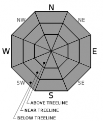
The avalanche danger is MODERATE near and above treeline. Warm temperatures and intense solar radiation will create wet and unconsolidated snow surfaces, and the likelihood of wet loose avalanches will increase throughout the day. Wind slabs also remain a concern, primarily on easterly aspects above treeline. The avalanche danger is LOW below treeline.


Avalanche Problem 1: Loose Wet
-
Character ?

-
Aspect/Elevation ?
-
Likelihood ?CertainVery LikelyLikelyPossible
 Unlikely
 -
Size ?HistoricVery LargeLargeSmall

Snow surfaces will experience intense solar radiation and a rapid warm up today. Loose wet avalanches are possible on all aspects and at all elevations, and the likelihood of these avalanches will increase throughout the day. Watch for roller balls and pinwheels as good indications that snow surfaces are loosing strength and that it’s time to move to a different aspect or to lower angle terrain. Loose wet avalanches will initiate at a point and entrain snow as they move downslope.
Avalanche Problem 2: Wind Slab
-
Character ?

-
Aspect/Elevation ?
-
Likelihood ?CertainVery LikelyLikelyPossible
Unlikely
-
Size ?HistoricVery LargeLargeSmall
Wind slabs remain a concern near and above treeline. Westerly winds were transporting snow and creating fresh wind slabs yesterday, primarily on easterly aspects in the alpine on Mount Shasta. Pillows of loaded snow and textured snow surfaces were visible on all aspects in upper elevation terrain. Older and thicker wind slabs were seen on slopes in near treeline areas as well. Watch for blowing snow and cornice formation today, and avoid slopes 35 degrees and steeper that are obviously wind loaded.
Forecast Discussion
The sunshine today will likely have a significant affect on snow surfaces. The recent snow has stayed cold and dry, and today we should experience the first rapid warm up since the storms ended. Watch for loose wet avalanches, especially by the afternoon, and also be aware of falling rime ice in alpine terrain on Mount Shasta. Wind slabs are still an issue as well, and backcountry travelers should continue to avoid steep wind loaded terrain. Enjoy the dry and clear weather today, as more snow is on the way for tomorrow and throughout next week.
We will issue our last avalanche advisory of the season tomorrow. Thank you to all who have supported the Mount Shasta Avalanche Center this winter!
Recent Observations
Skies were in and out of the clouds throughout the day yesterday, and temperatures remained below freezing for the past 24 hours at the 7000ft level and above on Mount Shasta. Snow surfaces stayed cold and dry out of Bunny Flat and in the Old Ski Bowl. The recent snow has settled quickly, and boot penetration was consistently 15-20cm. Winds were calm up to 9500ft, while above, blowing snow was visible. Steady westerly winds were predominantly loading easterly aspects above treeline. Wind slabs were observed near and above treeline, as were wind textured and rippled snow surfaces. A recent avalanche large enough to bury, injure, or kill a person was observed on the east aspect of Green Butte. The avalanche had a crown that was 1-2ft deep and 600ft wide, and the slide ran for 200 vertical feet. The avalanche occurred at the tail end of the recent storms, likely on Thursday.
Weather and Current Conditions
Weather Summary
Lingering overnight clouds will burn off early this morning, and today should bring mostly sunny skies. Temperatures at the 6000ft level are expected to hit 50 degrees F. Westerly winds will continue in the alpine on Mount Shasta and should blow at moderate speeds. The clear and dry weather window will close out late tonight. Snow showers are expected throughout the day tomorrow with freezing levels near 5500ft. A more robust system will arrive on Monday and is set to bring heavy snowfall. Unsettled weather will continue throughout the week.
-------------------------
In Mt Shasta City at 0500, we have a current temperature of 28 F
On Mt Shasta (South Side) in the last 24 hours...
Sand Flat - 6,750 ft. The current temperature is 17 degrees F. Temperatures have ranged from 16 F to 33 F. Snow on the ground totals 132 inches with no new snow and 3 inches of settlement.
Old Ski Bowl - 7,600ft. The current temperature is 17 degrees F. Temperatures have ranged from 8 F to 30 F. Snow on the ground totals 217 inches with no new snow and 3 inches of settlement.
Grey Butte - 8,000 feet. The current temperature is 18 degrees F. Temperatures have ranged from 11 F to 32 F. Winds have ranged from 5-10 mph with gusts to 21 mph, blowing from west/northwest and shifting to the east overnight.
Mt Eddy Range (West side of Interstate-5)...
Castle Lake - 5,800 feet. The current temperature is 18 degrees F. Temperatures have ranged from 20 F to 43 F. Snow on the ground totals 115 inches with no new snow little settlement.
Mt Eddy - 6,500 feet, the current temperature is 15 degrees F. Temperatures have ranged from 13 F to 33 F. Snow on the ground measures 109 inches with no new and 1 inch of settlement. Variable winds have averaged 2 mph with gusts up to 8 mph.
THIS SEASON PRECIPITATION for MT SHASTA CITY: Since October 1st (the wet season), we have received 56.44 inches of water, normal is 36.97 inches, putting us at 153% of normal. For the month of April, we have received 6.98 inches of water, normal is 1.51 inches, which is 462% of normal. And finally for the year of 2017, we received 35.28 inches of water, normal is 21.76 inches, putting us at 162% of normal.
Always check the weather before you attempt to climb Mt Shasta. Further, monitor the weather as you climb. Becoming caught on the mountain in any type of weather can compromise life and limb. Be prepared.
| 0600 temperature: | 17 |
| Max. temperature in the last 24 hours: | 33 |
| Average wind direction during the last 24 hours: | west/northwest |
| Average wind speed during the last 24 hours: | 5-10 mi/hr |
| Maximum wind gust in the last 24 hours: | 21 mi/hr |
| New snowfall in the last 24 hours: | 0 inches |
| Total snow depth: | 132 inches |
Two Day Mountain Weather Forecast
Produced in partnership with the Medford NWS
| For 7000 ft to 9000 ft | |||
|---|---|---|---|
|
Saturday (4 a.m. to 10 p.m.) |
Saturday Night (10 p.m. to 4 a.m.) |
Sunday (4 a.m. to 10 p.m.) |
|
| Weather | Mostly Sunny | Increasing Clouds | Snow and breezy. Snow mainly after 11am. Chance of precipitation is 100%. |
| Temperature (°F) | 44 | 30 | 39 |
| Wind (mi/hr) | northeast becoming southeast in the afternoon 6 mph | south/southeast 6-14 mph | south 16-24 mph, gusting 37 mph |
| Precipitation SWE / Snowfall (in) | / 0 | / 0 | / 1-2 |
| For 9000 ft to 11000 ft | |||
| Saturday | Saturday Night | Sunday | |
| Weather | Mostly sunny and breezy. Wind chill values as low as -4 F. | Increasing clouds and windy. | Snow and windy. Snow mainly after 11am. Wind chill values as low as -1 F. Chance of precipitation 100%. |
| Temperature (°F) | 23 | 22 | 22 |
| Wind (mi/hr) | south/southwest 26-29 mph, gusting 44 mph | south/southwest 0 | South 50-55 mph, gusting 85 mph |
| Precipitation SWE / Snowfall (in) | / 0 | / 0 | / 3-7 |

