

You are here
Avalanche Advisory for 2017-12-02 06:46:07
- EXPIRED ON December 3, 2017 @ 6:46 amPublished on December 2, 2017 @ 6:46 am
- Issued by Nick Meyers - Shasta-Trinity National Forest
Bottom Line
A winter weather advisory is in effect today. Southwest winds will dominate along with a couple inches of new snow. Low danger and normal caution is advised. Early season conditions rule. Large objects like rocks, trees and shrubs can be seen easily, other small hazards may lurk below new snow surfaces. Tread lightly.
Extremely icy conditions will be encountered on Mt Shasta above 8,000 feet. Be prepared. A climb of Mt Shasta with these conditions brings increased difficulty and consequences.


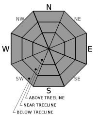
Avalanche Problem 1: Normal Caution
-
Character ?

-
Aspect/Elevation ?
-
Likelihood ?CertainVery LikelyLikelyPossible
 Unlikely
 -
Size ?HistoricVery LargeLargeSmall

Normal caution advised today. Perhaps a few may venture out to feel the cold bite of winter on their cheeks and fresh snow under feet. Low tide, early season conditions prevail. Continue to ride carefully. This afternoon, as new snow blows around watch for the rare, small wind pillow that may accumulate on leeward, mid slope areas where existing snow lies. If found, they likely will not pose a threat to human life but could cause a wobble on those slick snow surfaces.
Forecast Discussion
Season's Greetings from the Mt Shasta Avalanche Center and off we go into the 2017/18 winter season. We started of the season in late October and November with several tantalizing storms, enough for folks to get out and anticipate the true beginning of winter in the mountains. There was some decent accumulation at higher elevations. Late November brought warm temps and rain. Our snowpack was diminished some. Currently, we've got a rock solid and somewhat usable snowpack above 6,700 feet. This weekends storm will bring a few inches of new snow to the forecast area. Avalanches are still of low concern, but it's a perfect time to think about how we manage our risk in the backcountry with full-blown winter knocking at the door.
Remember the basics. Simply, hone your skils identifying avalanche terrain. Review the Red flags. Red flags are just that: Mother Natures NEON signs of obvious signs of snow instability. These red flags are useful data that require very little interpretation. What are they?
* Recent Avalanches
*Wind Loading
*Heavy snow or rainfall
*Significant warming
*Signs of unstable snow (cracking or whumpfing)
Other things to think about include scoping your favorite ski terrain ground cover. Which areas currently host snow and which areas are rock, dirt, shrubs? Areas with snow may be our first slide paths of the season. Take note.
Use all your resources. There is a TON of info out there. Browse our avalanche tutorials and brush up on lingo, maps, weather stations, recent observations, etc. Study up. Check your gear. Get dialed in. NOW is the time.
Recent Observations
In Mt Shasta City at 0500, we have a current temperature of 28 F
On Mt Shasta (South Side) in the last 24 hours...
Sand Flat - 6,750 ft, the current temperature is 28 degrees F. Temperatures have ranged from 26 F to 39 F. Snow on the ground totals 11 inches with .5 inch of new snow.
Old Ski Bowl - 7,600ft, the current temperature is 29 degrees F. Temperatures have ranged from 27 F to 35 F. Snow on the ground totals 19 inches with .5-1 inch of new snow.
Grey Butte - 8,000 feet, the current temperature is 29 degrees F. Temperatures have ranged from 26 F to 31 F. Winds have ranged from 13 mph with gusts to 24 mph, blowing mostly from the west/northwest
Mt Eddy Range (West side of Interstate-5)...
Castle Lake - 5,800 feet, the current temperature is 34 degrees F. Temperatures have ranged from 30 F to 42 F. Snow on the ground totals 10 inches with 0 inches of new snow.
Mt Eddy - 6,500 feet, the current temperature 33 degrees F. Temperatures have ranged from 27 F to 37 F. Snow on the ground measures 5 inches with 0 inches of new snow. Winds have averaged 1 mph out of the west/southwest with gusts up to 7 mph.
-----------------------------------------------------------------
Mt Shasta:
< 6,500 feet : No snow
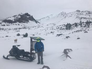
6,500 to 7,000 feet : Thin, patchy snowpack; some folks using upper Sand Flat road for XC-skiing. Snow on the ground just begins in this elevation band. Firm, icy, dirty.
7,000 to treeline : Average snow depth of 50-90 cm, supportable, firm snow. Rocks, trees, shrubs, dirt patches, old ski and boot tracks
Above treeline: Firm, hard snow, variable, decent coverage; rocks sticking out, completely scoured ridgelines; VERY ICY patches throughout above treeline terrain. Dust on crust in gullies if your lucky
Melt-freeze conditions prevail for snow surfaces; deeper layers in snowpack are well bonded and were previously affection by rain and melt.
Castle Lake:
More snow! Less than a foot of snow on the ground up there and the lake is not frozen.
Mt Eddy:
More snow! A tad more snow than Castle Lake but not a usable snowpack yet.
Weather and Current Conditions
Weather Summary
A WINTER WEATHER ADVISORY is in effect from 10 AM this morning to 4 AM PST Sunday, issued at 424 AM, December 2, 2017. Today, cloudy skies and a slight chance of snow this morning will lead to snow likely this afteroon. Models suggest about a quarter inch of water with this short blast with snow levels around 4,500 feet. Temperatures will drop today as this morning freezing levels are still much higher. Winds will function much out of the southwest until late tonight/tomorrow when a more northerly flow will ensue. This system will push east early Sunday. Lingering showers are possible, though sunshine will return. Strong high pressure is set to build Monday and will last through the week. Cold temps can be expected with inversions.
La Nina conditions are, at this time, present. Equatorial sea surface temperatures are below average across the central and eastern Pacific Ocean. La Nina conditions are predicted to continue at least through the Northern Hemisphere winter 2017/18.
December is a bit of a wild card in the long term. It's typically one of the wettest months, however at this point climate prediction models suggest below normal precipitation and above normal temps. We are hoping that later in the month Mother Nature will shake-n-bake something cold and white for us and shame the computer models!
=============================================================================
THIS SEASON PRECIPITATION for MT SHASTA CITY: Since October 1st (the wet season), we have received 5.54 inches of water, normal is 7.58 inches, putting us at 73% of normal. For the month of December, we received 0 inches of water, normal is .22 inches, which is 0% of normal. And finally for the year of 2017, we received 44.53 inches of water, normal is 35.58 inches, putting us at 125% of normal.
Always check the weather before you attempt to climb Mt Shasta. Further, monitor the weather as you climb. Becoming caught on the mountain in any type of weather can compromise life and limb. Be prepared.
| 0600 temperature: | 28 |
| Max. temperature in the last 24 hours: | 39 |
| Average wind direction during the last 24 hours: | West/Northwest |
| Average wind speed during the last 24 hours: | 13 mi/hr |
| Maximum wind gust in the last 24 hours: | 24 mi/hr |
| New snowfall in the last 24 hours: | .5-1 inches |
| Total snow depth: | 12 inches |
Two Day Mountain Weather Forecast
Produced in partnership with the Medford NWS
| For 7000 ft to 9000 ft | |||
|---|---|---|---|
|
Saturday (4 a.m. to 10 p.m.) |
Saturday Night (10 p.m. to 4 a.m.) |
Sunday (4 a.m. to 10 p.m.) |
|
| Weather | Snow likely, mainly between 10am and 4pm, then snow showers after 4pm. The snow could be heavy at times. Windy. | Snow showers, mainly before 10pm. Breezy. | A 50 percent chance of snow showers, mainly before 10am. Partly sunny. |
| Temperature (°F) | 31, falling to 26 | 20 | 26 |
| Wind (mi/hr) | South 10-15 | Southwest 10-15 | West 10-15 |
| Precipitation SWE / Snowfall (in) | / 2-4 | / 2-4 | / 0-1 |
| For 9000 ft to 11000 ft | |||
| Saturday | Saturday Night | Sunday | |
| Weather | Snow likely, mainly between 10am and 4pm, then snow showers after 4pm. The snow could be heavy at times. Windy. Wind chill values as low as -15. | Snow showers, mainly before 10pm. Low around 5. Windy. Wind chill values as low as -20. | A 50 percent chance of snow showers, mainly before 10am. Partly sunny, with a high near 12. Windy. Wind chill values as low as -22. |
| Temperature (°F) | 21, falling | 5 | 12 |
| Wind (mi/hr) | Southwest 40-50 mph | Southwest 3-6 | Northwest 30-40 mph |
| Precipitation SWE / Snowfall (in) | / 3-6 | / 3-6 | / 0-1 |

