

You are here
Avalanche Advisory for 2017-12-04 06:57:48
- EXPIRED ON December 5, 2017 @ 6:57 amPublished on December 4, 2017 @ 6:57 am
- Issued by Andrew Kiefer - Mt Shasta Avalanche Center
Bottom Line
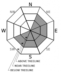
Wind slabs 1-2ft thick exist on NE-E-SE-S-SW aspects near treeline and above treeline. The avalanche danger is MODERATE above treeline and LOW near and below treeline today. Natural avalanches are unlikely while human triggered avalanches remain possible.


Avalanche Problem 1: Wind Slab
-
Character ?

-
Aspect/Elevation ?
-
Likelihood ?CertainVery LikelyLikelyPossible
 Unlikely
 -
Size ?HistoricVery LargeLargeSmall

Natural and human triggered avalanches have occurred recently, and a wind slab problem is the primary avalanche concern in the backcountry. Wind slabs may exist on NE-E-SE-S-SW aspects near and above treeline. These slabs are 1-2ft thick, and are resting on a slick and icy bed surface. Watch for active wind transport of snow today, and identify slopes that are wind loaded. Rippled snow surfaces, wind drifts, and hollow sounding snow are good indications of a wind slab presence. Avoid wind loaded slopes 35 degrees and steeper.
Forecast Discussion
Our recent snowy and cold weather has come and gone and we are set for clear skies and warming temperatures. Wind slabs are a concern on steep wind loaded slopes in terrain 8000ft and higher on Mount Shasta. Thin snow cover posses a significant hazard for anyone venturing out into the backcountry to ski or ride. Winds will likely keep snow surfaces cool today, but monitor snow surfaces as they warm up throughout the week. Roller balls and wet heavy snow surfaces may occur, and are good indications that wet loose avalanches are possible.
All the red flags for avalanche danger have been present in our advisory area recently – avalanches, wind loading, heavy snowfall, signs of unstable snow (cracking), and significant warming is expected by tomorrow. Pay attention out there and always be on the look out for these factors. Our recent avalanches have been small and have occurred in specific wind loaded areas. Regardless, getting caught in an avalanche in these thin and rocky snowpack conditions would be a nasty situation.
Remember the basics as you start venturing out into the backcountry this early season. Carry avalanche rescue gear and know how to use it. Browse our avalanche tutorials and brush up on avalanche basics, maps, weather stations, recent observations, etc. Check your gear. Get dialed in. NOW is the time.
Recent Observations
The first avalanche activity of the season occurred during and immediately following our most recent storm. Several small wind slab avalanches were observed yesterday on the south side of Mount Shasta. These avalanches occurred in heavily wind loaded areas in near treeline and above treeline terrain and were not large enough to bury, injure, or kill a person.
Three natural wind slab avalanches were observed on the south and southeast aspects of Sun Bowl between 8200-8400ft. The crowns were 1ft deep or less, broke 40-60ft wide, and each slide ran 30-50ft downslope. A snowmobiler triggered avalanche occurred on a road bank in the Old Ski Bowl yesterday as well. The crown of the avalanche was also 1ft deep, 60ft wide, and ran for 30ft downslope.
Strong northwest winds transported snow continuously throughout the day yesterday, primarily in areas 8000ft and higher. Drifts of new snow were observed as deep as 2 feet. A shooting crack was also observed on a southeast slope near treeline. The height of new snow was consistently 6 inches in wind protected areas between 7000-9000ft. Many wind ward slopes were scoured down to the old snow surfaces and were extremely firm and icy.

Weather and Current Conditions
Weather Summary
A ridge of high pressure will begin building strongly over the advisory area today and will remain in place throughout the week. Unusually warm temperatures and dry conditions are expected in the mountains along with valley temperature inversions. Winds have shifted to the northeast and will be strong and gusty at upper elevations. Temperature highs for the day at the 6000ft level will be in the mid to upper 30’s. Clear, sunny, warm weather will continue through the weekend.
=============================================================================
THIS SEASON PRECIPITATION for MT SHASTA CITY: Since October 1st (the wet season), we have received 5.72 inches of water, normal is 8.03 inches, putting us at 71% of normal. For the month of December, we received .18 inches of water, normal is .67 inches, which is 27% of normal. And finally for the year of 2017, we received 44.71 inches of water, normal is 36.03 inches, putting us at 124% of normal.
In Mt Shasta City at 0500, we have a current temperature of 31 F
On Mt Shasta (South Side) in the last 24 hours...
Sand Flat - 6,750 ft, the current temperature is 16 degrees F. Temperatures have ranged from 13 F to 23 F. Snow on the ground totals 15 inches with no new snow and little settlement.
Old Ski Bowl - 7,600ft, the current temperature is 18 degrees F. Temperatures have ranged from 18 F to 31 F. Snow on the ground totals 24 inches with no new snow and 1 inche of settlement.
Grey Butte - 8,000 feet, the current temperature is 27 degrees F. Temperatures have ranged from 14 F to 27 F. Winds have averaged 15-30 mph with gusts to 64 mph, blowing from the west/northwest and becoming variable in direction overnight.
Mt Eddy Range (West side of Interstate-5)...
Castle Lake - 5,800 feet, the current temperature is 20 degrees F. Temperatures have ranged from 19 F to 26 F. Snow depths are not reading accurrately at this time, but are minimal at this station.
Mt Eddy - 6,500 feet, the current temperature 23 degrees F. Temperatures have ranged from 19 F to 23 F. Snow on the ground measures 12 inches with no new snow. and little settlement. Winds have averaged 2-3 mph with gusts to 12 mph blowing out of the south.
Always check the weather before you attempt to climb Mt Shasta. Further, monitor the weather as you climb. Becoming caught on the mountain in any type of weather can compromise life and limb. Be prepared.
| 0600 temperature: | 16 |
| Max. temperature in the last 24 hours: | 23 |
| Average wind direction during the last 24 hours: | West/Northwest |
| Average wind speed during the last 24 hours: | 15-30 mi/hr |
| Maximum wind gust in the last 24 hours: | 64 mi/hr |
| New snowfall in the last 24 hours: | 0 inches |
| Total snow depth: | 15 inches |
Two Day Mountain Weather Forecast
Produced in partnership with the Medford NWS
| For 7000 ft to 9000 ft | |||
|---|---|---|---|
|
Monday (4 a.m. to 10 p.m.) |
Monday Night (10 p.m. to 4 a.m.) |
Tuesday (4 a.m. to 10 p.m.) |
|
| Weather | Sunny | Mostly Clear | Sunny |
| Temperature (°F) | 33 | 22 | 44 |
| Wind (mi/hr) | Northeast 17-20 | East/Northeast 15-20 | East 9-11 |
| Precipitation SWE / Snowfall (in) | / 0 | / 0 | / 0 |
| For 9000 ft to 11000 ft | |||
| Monday | Monday Night | Tuesday | |
| Weather | Sunny and windy. Wind chill values as low as -11. | Mostly clear and windy. | Sunny |
| Temperature (°F) | 25 | 25 | 33 |
| Wind (mi/hr) | North/Northeast 25 mph, gusting 60-65 mph | North/Northeast 0 | East/Northeast 11-17 mph, gusting 26 mph |
| Precipitation SWE / Snowfall (in) | / 0 | / 0 | / 0 |

