

You are here
Avalanche Advisory for 2017-12-09 06:09:16
- EXPIRED ON December 10, 2017 @ 6:09 amPublished on December 9, 2017 @ 6:09 am
- Issued by Nick Meyers - Shasta-Trinity National Forest
Bottom Line
The avalanche danger is LOW at all elevations and aspects today. Use extra caution when traveling in exposed, steep terrain with high consequences where typically small and benign avalanches pose a significant hazard. Also, watch out for sudden patches of icy snow surfaces on the upper mountain. Self arrest could be difficult.


Avalanche Problem 1: Normal Caution
-
Character ?

-
Aspect/Elevation ?
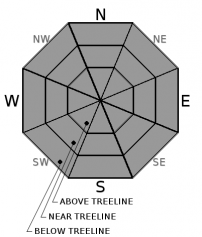
-
Likelihood ?CertainVery LikelyLikelyPossible
 Unlikely
 -
Size ?HistoricVery LargeLargeSmall

Normal caution is advised today. Natural and human triggered avalanches are unlikely. Low danger does not mean the backcountry is free of hazard. Isolated slabs are generally related to wind and terrain: look for places where small areas of drifting have occurred and firm layers of surface snow overlie softer layers. Often this will occur on the lee side of ridges, in terrain depressions, on convex terrain features, and in the lee of isolated bands of trees.
Forecast Discussion
Little change should be seen today. Expect sunny weather, warm temperatures and light alpine winds. Avalanche instability is going to be hard to come by. Mt Shasta's top backcountry hazards include:
*Firm, icy snow surfaces on the upper mountain. A slip and fall could be fatal, especially with many of the rocks that still protrude from the snowpack
*Rime ice formations on exposed rocks. Rime ice has the potential to flake off and fall down the slopes below. Wear a helmet. Keep you head up! (Good advice for life, too)
*Typical early season hazards
With limited terrain available for riding, take the time to practice with your rescue gear if you get out.
If you have not seen this video, give it a watch (4 min): TO HELL IN A HEARTBEAT
Recent Observations
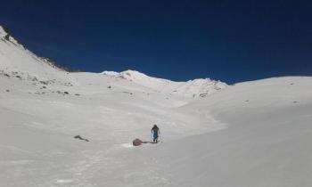
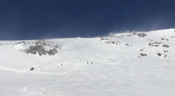
Strong inversions again today. Overnight lows on the mountain did not reach freezing. Freezing levels have been near 10 to 11,000 feet. Snow surface conditions continue to stay the same. Some have reported some decent corn skiing, considering the conditions, in select areas on the south side.
A variety of snow surfaces will be found on Mt Shasta:
*Firm, icy and bombproof old snow
*Corn snow on southerly slopes unaffected by wind
*Wind slab "scabs", small with random distribution
*Overall, it's still a barely usable, early season snowpack - rocks, trees, shrubs, punji sticks, snaggletooths and snow snakes!
Mt Eddy and Castle Lake do not have enough snow for winter recreation. Sand Flat hosts a thin snowpack barely usable for cross country skiing. Pilgrim Creek snowmobile park has a thin layer of snow, but any snow machine fun will require several more miles of travel up Military Pass road. Off piste riding is not in yet for sledders on the east side.

Weather and Current Conditions
Weather Summary
The high pressure ridge that has blocked the storm track and resulted in some record highs in the last several days is expected to persist through the middle of the month. This means that strong inversions between valleys and mountains are expected to continue. Thereafter, recent model guidance is indicating a weak to modest frontal system or two moving through under a west-northwest flow between the 15th and 20th, followed by another period of more transitory ridging before the ridge breaks down more definitively between the 21st and 28th. A key to this pattern evolution is likely the Madden Julian Oscillation (MJO) remaining significant into phase 7 (moving eastward through the Western Pacific). Additionally, if the Arctic Oscillation trends toward neutral, this would be favorable for the storm track to return to our area. December is, per 1981-2010 averages, the wettest month of the year for our forecast area from the Cascades westward, and ranks 2nd wettest to November for most areas east of the Cascades. Thus, it's an important month in the water year and for our seasonal snowpack. (B. Lutz, NWS Medford)
-----------------------------------------------------------
THIS SEASON PRECIPITATION for MT SHASTA CITY: Since October 1st (the wet season), we have received 5.72 inches of water, normal is 9.21 inches, putting us at 62% of normal. For the month of December, we have received .18 inches of water, normal is 1.85 inches, which is 9% of normal. And finally for the year of 2017, we received 44.71 inches of water, normal is 37.21 inches, putting us at 120% of normal.
Always check the weather before you attempt to climb Mt Shasta. Further, monitor the weather as you climb. Becoming caught on the mountain in any type of weather can compromise life and limb. Be prepared.
24 Hour Weather Station Data @
| Weather Station | Temp (°F) | Wind (mi/hr) | Snow (in) | Comments | ||||||||
|---|---|---|---|---|---|---|---|---|---|---|---|---|
| Cur | Min | Max | Avg | Avg | Max Gust | Dir | Depth | New | Water Equivalent | Settlement | ||
| Mt. Shasta City (3540 ft) | 27 | 26 | 52 | 35 | 3 | NNE | ||||||
| Sand Flat (6750 ft) | 34 | 31 | 49 | 36 | 14.5 | 0 | 0 | 0 | ||||
| Ski Bowl (7600 ft) | 43 | 42 | 53 | 45 | 17.8 | 0 | 0 | 0 | ||||
| Gray Butte (8000 ft) | 45 | 43 | 53 | 47 | 9 | 24 | NE | |||||
| Castle Lake (5870 ft) | 42 | 42 | 48 | 44 | 3.1 | |||||||
| Mount Eddy (6509 ft) | 37 | 36 | 50 | 41 | 2 | 5 | WSW | 11 | ||||
| Ash Creek Bowl (7250 ft) | Station Down | |||||||||||
| Ash Creek Ridge (7895 ft) | Station Down |
Two Day Mountain Weather Forecast
Produced in partnership with the Medford NWS
| For 7000 ft to 9000 ft | |||
|---|---|---|---|
|
Saturday (4 a.m. to 10 p.m.) |
Saturday Night (10 p.m. to 4 a.m.) |
Sunday (4 a.m. to 10 p.m.) |
|
| Weather | Sunny | Clear | Sunny |
| Temperature (°F) | 51 | 39 | 52 |
| Wind (mi/hr) | East/Southeast 3-5 | East/Northeast 3-5 | Southeast 3-5 |
| Precipitation SWE / Snowfall (in) | / 0 | / 0 | / 0 |
| For 9000 ft to 11000 ft | |||
| Saturday | Saturday Night | Sunday | |
| Weather | Sunny | Clear | Sunny |
| Temperature (°F) | 37 | 37 | 39 |
| Wind (mi/hr) | South 5-10 | South/Southeast 0 | South/Southeast 10-15 |
| Precipitation SWE / Snowfall (in) | / 0 | / 0 | / 0 |

