

You are here
Avalanche Advisory for 2017-12-12 06:21:44
- EXPIRED ON December 13, 2017 @ 6:21 amPublished on December 12, 2017 @ 6:21 am
- Issued by Andrew Kiefer - Mt Shasta Avalanche Center
Bottom Line
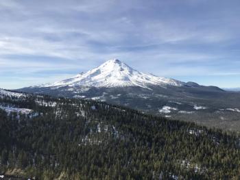
Triggering an avalanche is unlikely, and LOW avalanche danger exists throughout the advisory area. In terrain 7,000ft and higher on Mount Shasta, backcountry travelers will encounter a firm, icy, and thin snowpack. Watch out for shallowly buried objects. A slide for life could easily occur in these conditions.


Avalanche Problem 1: Normal Caution
-
Character ?

-
Aspect/Elevation ?
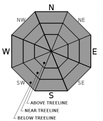
-
Likelihood ?CertainVery LikelyLikelyPossible
 Unlikely
 -
Size ?HistoricVery LargeLargeSmall

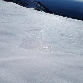
After a week of melt-freeze cycles, our already consolidated and rock-hard snowpack continues to strengthen. Both natural and human triggered avalanches are unlikely and normal caution is advised. Traveling on very firm and icy slopes on Mount Shasta, or hitting a shallowly buried object are the most significant hazards in the backcountry right now.
Forecast Discussion
Snowpack stability is very good, and until we get more snow, LOW avalanche danger and normal caution will continue. Conditions are certainly variable, and a large portion of our advisory area is snow free. Where snow does exist and winter recreation is possible, the risks of a slip and fall or hitting an obstacle under the snow surface are far more likely than triggering an avalanche. If you venture into high alpine terrain on Mount Shasta, expect to encounter slick and icy snow surfaces. Be prepared to arrest a slip or fall and bring an ice axe, crampons, and a helmet.
Recent Observations
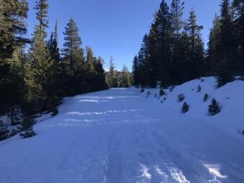
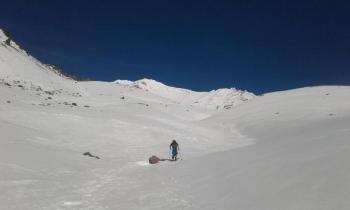
Little change has occurred in the overall snow conditions for our advisory area during the past week. No signs of instability have been observed or reported since our last storm ended on December third. Despite the recent warm weather, we have not lost much snow height, and our existing snowpack continues to hang in there. The snow is consistently 1.5-2ft deep in terrain 7,000ft and higher on Mount Shasta, which is by far the most functional snowpack we have.
The winds picked up yesterday and kept snow surfaces cold in the Old Ski Bowl. South facing slopes steeper than 30 degrees that receive direct sun exposure softened by the middle of the day. The majority of snow surfaces remained firm and icy, though. No evidence of loaded snow or a wind slab problem was observed.
Weather and Current Conditions
Weather Summary
High pressure will continue to bring dry and sunny conditions along with valley temperature inversions for the next several days. Freezing levels will remain near 11,000ft with high temperatures for today near 50 degrees. Winds will shift slightly to the north/northeast and will remain light. A shortwave trough of low pressure looks to move through the area this weekend. Right now, it appears the trough may weaken the persistent valley-mountain inversions, but will not likely produce much, if any precipitation for our advisory area. High pressure will be quick to rebuild under southwest flow following the weekend’s short-lived disturbance.
-----------------------------------------------------------
THIS SEASON PRECIPITATION for MT SHASTA CITY: Since October 1st (the wet season), we have received 5.72 inches of water, normal is 9.93 inches, putting us at 58% of normal. For the month of December, we have received .18 inches of water, normal is 2.57 inches, which is 7% of normal. And finally for the year of 2017, we received 44.71 inches of water, normal is 37.93 inches, putting us at 118% of normal.
Always check the weather before you attempt to climb Mt Shasta. Further, monitor the weather as you climb. Becoming caught on the mountain in any type of weather can compromise life and limb. Be prepared.
24 Hour Weather Station Data @ 5:00 AM
| Weather Station | Temp (°F) | Wind (mi/hr) | Snow (in) | Comments | ||||||||
|---|---|---|---|---|---|---|---|---|---|---|---|---|
| Cur | Min | Max | Avg | Avg | Max Gust | Dir | Depth | New | Water Equivalent | Settlement | ||
| Mt. Shasta City (3540 ft) | 29 | 23 | 50 | 32 | 3 | |||||||
| Sand Flat (6750 ft) | 30 | 30 | 51 | 35 | 15 | 0 | 0 | 0 | ||||
| Ski Bowl (7600 ft) | 44 | 40 | 54 | 46 | 17 | 0 | 0 | 0 | ||||
| Gray Butte (8000 ft) | 45 | 43 | 52 | 46 | 10 | 25 | WNW | |||||
| Castle Lake (5870 ft) | 49 | 43 | 54 | 48 | 0 | 0 | 0 | |||||
| Mount Eddy (6509 ft) | 35 | 35 | 54 | 41 | 3 | 5 | WSW | 11 | 0 | 0 | ||
| Ash Creek Bowl (7250 ft) | Station Down | |||||||||||
| Ash Creek Ridge (7895 ft) | Station Down |
Two Day Mountain Weather Forecast
Produced in partnership with the Medford NWS
| For 7000 ft to 9000 ft | |||
|---|---|---|---|
|
Tuesday (4 a.m. to 10 p.m.) |
Tuesday Night (10 p.m. to 4 a.m.) |
Wednesday (4 a.m. to 10 p.m.) |
|
| Weather | Sunny | Mostly Clear | Sunny |
| Temperature (°F) | 53 | 39 | 54 |
| Wind (mi/hr) | North 5-7 | Northeast light | North 3-5 |
| Precipitation SWE / Snowfall (in) | / 0 | / 0 | / 0 |
| For 9000 ft to 11000 ft | |||
| Tuesday | Tuesday Night | Wednesday | |
| Weather | Sunny | Mostly Clear | Sunny |
| Temperature (°F) | 36 | 38 | 41 |
| Wind (mi/hr) | South/Southwest 16-21 mph, gusting 31 mph | West/Southwest 0 | North 10-16 mph, gusting 24 mph |
| Precipitation SWE / Snowfall (in) | / 0 | / 0 | / 0 |

