

You are here
Avalanche Advisory for 2017-12-14 06:20:38
- EXPIRED ON December 15, 2017 @ 6:20 amPublished on December 14, 2017 @ 6:20 am
- Issued by Nick Meyers - Shasta-Trinity National Forest
Bottom Line
LOW avalanche danger exists at all elevations. Natural and human triggered avalanches are unlikely. Exercise normal caution when traveling in the backcountry. Smooth and firm snow surfaces exist and a slide for life could occur in the event of a fall. Keep an eye out for falling rime ice. Wear a helmet, carry an ice axe and crampons, know how to use them.


Avalanche Problem 1: Normal Caution
-
Character ?

-
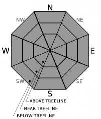
Aspect/Elevation ?
-
Likelihood ?CertainVery LikelyLikelyPossible
 Unlikely
 -
Size ?HistoricVery LargeLargeSmall

Avalanche danger is LOW at all elevations. Natural and human triggered avalanches are unlikely. Normal caution is advised. Normal caution means:
- Be vigilant.
- Travel with a partner.
- Carry a beacon, shovel, and probe.
- Pay attention to changing snow conditions.
- Keep an eye out for isolated pockets of instability.
Forecast Discussion
Winter is kind of like having a baby...eventually it's going to happen. A slight disturbance will move through the area tomorrow afternoon/evening but don't expect much, if anything out of it.
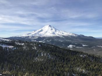
The good weather may entice a few climbers to give Shasta a go this weekend. Contestants should take note of increasing winds (northerly, 40+ mph) this weekend as well as firm and slick snow surfaces. A slip and fall could be disaster. Rime ice is plastered on exposed rocks and could flake off onto climbers below. Wear a helmet. Pay attention. Be prepared. A climb in these types of conditions (wind/cold/ice) ups the stakes considerably.
Recent Observations
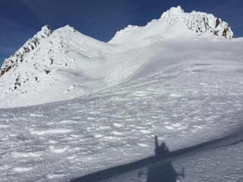
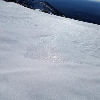
Temperatures at the 6,500 to 8,000 foot level last night did not get below 40 degrees. Valley inversions continue with lows in the high 20's F in Mt Shasta City. Firm, slick snow conditions prevail with some corn snow on sunny slopes perpendicular to the sun. Our dense snowpack is holding strong despite the warm overnight temperatures. Cold pockets of softer snow still exist in below and near treeline, northerly facing terrain. Smoke in the sky from California wildfires has diminished some.
Weather and Current Conditions
Weather Summary
A strong upper level ridge continues to dominate the weather pattern. The ridge will weaken Friday as a short wave moves over the top of it. This will push a weak front onshore. Associated precipitation will be minimal though with amounts less than .10 inches. There will likely be enough cooling aloft to break some of the extreme valley inversions we've been seeing. This "break" in the weather won't last long. Our good friend High Pressure will return this weekend as a rex block sets up off shore. Windy conditions can be expected on the mountain, picking up late Friday and accelerating into the weekend. For today, sunny and pleasant.
------------------------------------------------------------------
THIS SEASON PRECIPITATION for MT SHASTA CITY: Since October 1st (the wet season), we have received 5.72 inches of water, normal is 10.43 inches, putting us at 54% of normal. For the month of December, we have received .18 inches of water, normal is 3.07 inches, which is 5% of normal. And finally for the year of 2017, we received 44.71 inches of water, normal is 38.43 inches, putting us at 116% of normal.
Always check the weather before you attempt to climb Mt Shasta. Further, monitor the weather as you climb. Becoming caught on the mountain in any type of weather can compromise life and limb. Be prepared.
24 Hour Weather Station Data @ 5:00 AM
| Weather Station | Temp (°F) | Wind (mi/hr) | Snow (in) | Comments | ||||||||
|---|---|---|---|---|---|---|---|---|---|---|---|---|
| Cur | Min | Max | Avg | Avg | Max Gust | Dir | Depth | New | Water Equivalent | Settlement | ||
| Mt. Shasta City (3540 ft) | 27 | 27 | 49 | 37 | 4 | NE | ||||||
| Sand Flat (6750 ft) | 32 | 32 | 51 | 39 | 14 | 0 | 0 | 2 | ||||
| Ski Bowl (7600 ft) | 49 | 44 | 54 | 49 | 18 | 0 | 0 | 5 | ||||
| Gray Butte (8000 ft) | 48 | 46 | 58 | 51 | 4 | 31 | NW | |||||
| Castle Lake (5870 ft) | 43 | 42 | 55 | 48 | 8 | 6 | 2 | |||||
| Mount Eddy (6509 ft) | 42 | 38 | 57 | 49 | 2 | 9 | WSW | 10 | 2 | 3 | ||
| Ash Creek Bowl (7250 ft) | ||||||||||||
| Ash Creek Ridge (7895 ft) |
Two Day Mountain Weather Forecast
Produced in partnership with the Medford NWS
| For 7000 ft to 9000 ft | |||
|---|---|---|---|
|
Thursday (4 a.m. to 10 p.m.) |
Thursday Night (10 p.m. to 4 a.m.) |
Friday (4 a.m. to 10 p.m.) |
|
| Weather | Sunny | Clear | Partly cloudy, then becoming mostly cloudy in the afternoon. Slight chance of snow showers after 4pm |
| Temperature (°F) | 57 | 41 | 50 and falling |
| Wind (mi/hr) | Northeast 10-15 | Northeast 5-10 | West 5-10, increasing |
| Precipitation SWE / Snowfall (in) | / 0 | / 0 | / 0-.5 |
| For 9000 ft to 11000 ft | |||
| Thursday | Thursday Night | Friday | |
| Weather | Sunny | Partly cloudy, breezy | Partly cloudy, then becoming mostly cloudy, windy, slight chance of snow showers after 4pm |
| Temperature (°F) | 44 | 38 | 38 |
| Wind (mi/hr) | North 10-15 | Northwest 0 | West 25-30, increasing in the evening to 40+ mph |
| Precipitation SWE / Snowfall (in) | / 0 | / 0 | / 0-.5 |

