

You are here
Avalanche Advisory for 2017-12-23 06:28:31
- EXPIRED ON December 24, 2017 @ 6:28 amPublished on December 23, 2017 @ 6:28 am
- Issued by Nick Meyers - Shasta-Trinity National Forest
Bottom Line
Avalanche conditions are generally safe in the backcountry and LOW avalanche danger remains for all aspects & elevations. Evaluate terrain carefully, identify where avalanche problems exist and avoid those areas. Watch for unstable snow on isolated terrain features.
Scoured ridgelines and icy surfaces dominate the upper mountain along with many rocks protruding from the thin snowpack. Climbers and ski mountaineers, use extreme caution on steep slopes. Carry an ice axe, crampons and helmet and know how to use them.


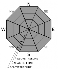
Avalanche Problem 1: Normal Caution
-
Character ?

-
Aspect/Elevation ?
-
Likelihood ?CertainVery LikelyLikelyPossible
 Unlikely
 -
Size ?HistoricVery LargeLargeSmall

Use NORMAL CAUTION, that is:
- Always watch for isolated slabs.
- Ski and ride one at a time in avalanche terrain.
- Don't regroup in run out zones
- Basic avalanche rescue skills are always essential when you travel in avalanche terrain.
Isolated slabs are generally related to wind and terrain: look for places where small areas of drifting have occurred and firm layers of surface snow overlie softer layers. Often this will occur on the lee side of ridges, in terrain depressions, on convex terrain features, and in the lee of isolated bands of trees.
Forecast Discussion
Happy Holidays to all. We wish you a safe and wonderful weekend. A white Christmas is looking likely, just enough to grease the skids of Santa's sleigh. It's been a painfully slow start to Winter in the area, but that's just the way it is. Let us be thankful for our family, friends, health and this wonderful place we live...and the little bit of snow we DO have to slide and ride on!
Significant avalanches have not been observed this year. Our snowpack is thin and most classic slide paths are not quite covered in snow yet. A number of folks are still enjoying the skiing and riding... just be sure to throttle back a bit -- many hard obstacles await for unlucky skis, skin and bones.
Recent Observations
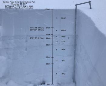
*The best snow coverage exists in sheltered areas, concavities, gullies and depressions near and above treeline, with the exception of ridgelines, moraine tops and slopes exposed to direct wind. Upper mountain slopes are most definitely scoured and icy. A slide for life is a possibility.
*Average 1-2 feet of snow coverage above 7,000 feet.
*Moist, sticky new snow (Tuesday night storm) interspersed with scabby, old melt/freeze snow on south and east facing slopes. Isolated low density snow can still be found in northerly, protected areas near treeline.
*Many rocks, down trees, small tree tops and bushes are showing.
*On the eastside yesterday, gusty westerly winds, above treeline, 10-20 mph, temps in the low 30's at 8,000 feet, and obscured, cloudy skies were observed
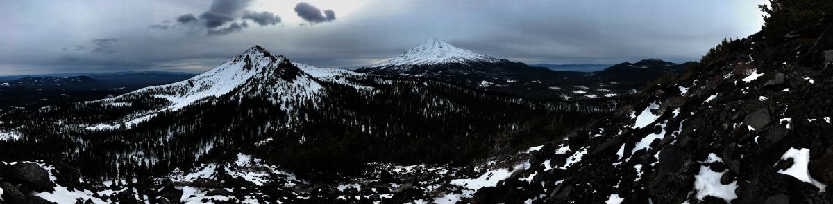
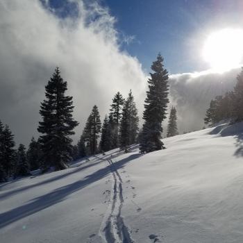
Panorama of the Eastside, Ash Creek Butte and Mt Shasta visible, 12.22.17 / Photo: N Meyers

Weather and Current Conditions
Weather Summary
We can now say that Winter has officially commenced. It's safe to believe that since you are reading this, you bought a ticket to the show. Now let's get the party started! Mostly dry air will dominate today. Only the highest peaks will see a chance of light snowfall. This pattern will change tonight as a warm front, then a cold front passes through the Pacific Northwest. Christmas Eve will host some precipitation. Snowfall amounts are minimal, but should be enough for a thin blanket of fresh white stuff. Westerly flow on the mountain will keep wind speeds moderate above treeline. Next week, precipitation is forecast for midweek and the weekend. Zonal flow will NOT block frontal passages and the proverbial storm doors should open for future fronts.
---------------------------------------------------
THIS SEASON PRECIPITATION for MT SHASTA CITY: Since October 1st (the wet season), we have received 5.83 inches of water, normal is 12.88 inches, putting us at 45% of normal. For the month of December, we have received .29 inches of water, normal is 5.52 inches, which is 5% of normal. And finally for the year of 2017, we received 44.82 inches of water, normal is 40.88 inches, putting us at 109% of normal.
Always check the weather before you attempt to climb Mt Shasta. Further, monitor the weather as you climb. Becoming caught on the mountain in any type of weather can compromise life and limb. Be prepared.
24 Hour Weather Station Data @ 5:00 AM
| Weather Station | Temp (°F) | Wind (mi/hr) | Snow (in) | Comments | ||||||||
|---|---|---|---|---|---|---|---|---|---|---|---|---|
| Cur | Min | Max | Avg | Avg | Max Gust | Dir | Depth | New | Water Equivalent | Settlement | ||
| Mt. Shasta City (3540 ft) | 31 | 30 | 38 | 34 | 1 | N | ||||||
| Sand Flat (6750 ft) | 32 | 27 | 39 | 33 | 15 | 0 | 0 | 0 | ||||
| Ski Bowl (7600 ft) | 34 | 30 | 38 | 34 | 20 | 0 | 0 | 2 | ||||
| Gray Butte (8000 ft) | 33 | 28 | 36 | 32 | 21 | 43 | WNW | |||||
| Castle Lake (5870 ft) | 36 | 30 | 41 | 35 | 3 | 0 | 0 | |||||
| Mount Eddy (6509 ft) | 34 | 33 | 44 | 37 | 1 | 10 | WSW | 10 | 0 | 0 | ||
| Ash Creek Bowl (7250 ft) | Station Down | |||||||||||
| Ash Creek Ridge (7895 ft) | Station Down |
Two Day Mountain Weather Forecast
Produced in partnership with the Medford NWS
| For 7000 ft to 9000 ft | |||
|---|---|---|---|
|
Saturday (4 a.m. to 10 p.m.) |
Saturday Night (10 p.m. to 4 a.m.) |
Sunday (4 a.m. to 10 p.m.) |
|
| Weather | Partly to mostly cloudy | Mostly cloudy | Mostly cloudy, chance of snow showers |
| Temperature (°F) | 39 | 32 | 40 |
| Wind (mi/hr) | Southwest 5-10 mph | Southeast 5-10 mph | South 5-10 mph |
| Precipitation SWE / Snowfall (in) | / 0 | / 0 | / 0 |
| For 9000 ft to 11000 ft | |||
| Saturday | Saturday Night | Sunday | |
| Weather | Partly to mostly cloudy, windy, slight chance of upper elevation snow showers, little to no accumulation | Mostly cloudy, windy, slight chance of upper elevation snow showers, little to no accumulation | Mostly cloudy, windy, chance of snow showers, snow levels near 4,000 feet |
| Temperature (°F) | 30 | 27 | 27 |
| Wind (mi/hr) | West 20-30 mph | West 0-.5 | Southwest 20-30 mph |
| Precipitation SWE / Snowfall (in) | / 0-.5 | / 0-.5 | / 1-2 |

