

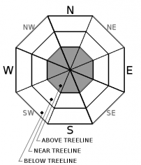
You are here
Avalanche Advisory for 2018-01-04 06:53:40
- EXPIRED ON January 5, 2018 @ 6:53 amPublished on January 4, 2018 @ 6:53 am
- Issued by Nick Meyers - Shasta-Trinity National Forest
Bottom Line
Above treeline on Mount Shasta, the avalanche danger is MODERATE. Human triggered avalanches are possible on steep, recently wind drifted slopes and particularly on slopes facing the north half of the compass. Near and below treeline offers generally LOW avalanche danger with continued shallow snowpack hazards. Watch out for icy slopes in select areas on the upper mountain.


Avalanche Problem 1: Wind Slab
-
Character ?

-
Aspect/Elevation ?
-
Likelihood ?CertainVery LikelyLikelyPossible
 Unlikely
 -
Size ?HistoricVery LargeLargeSmall

Strong southerly winds and new snow will create fresh wind slabs above treeline on Mount Shasta. Danger may increase throughout the day. These new wind slabs sit on a variety of snow surfaces from firm crusts to softer, old snow. Watch for areas of recently wind transported snow such as fresh cornices, snow drifts, and uneven snow surfaces. Identify and avoid locations where recent wind loading has occurred. Slabs could be large enough to take one for a ride into undesirable terrain and/or bury a person, especially in a terrain trap.
Wind slabs can be deceptively difficult to manage in the terrain. Take a moment and read the recent blog post by NWAC Pro Observer Jeremy Allyn on wind slabs.
Forecast Discussion
Change is the word of the day. The next 48 hours will present new snow and strong southerly winds. Temperatures and snow levels remain high. The wind slab problem will be primarily confined to above treeline terrain. Today, uncertainty lies in how well the new snow and wind slabs have bonded to old, icy snow surfaces. Often times warm storms "paste" onto old snow surfaces very well, but this is not guaranteed. Remember, the avalanche danger is most often the highest immediately during or just after a storm. If you venture out for some freshies, pay attention...and watch out for rocks.
Recent Observations
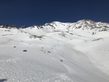
Yesterday was warm and windy throughout the advisory area. Average 24 hour temperatures have hovered in the high 30's to low 40's F. Southerly winds have picked up this morning, 10-20 mph with gusts to 25 mph. Only an inch of new snow was received last night (Old Ski Bowl weather station), perhaps a bit more up higher.
A trip out to the east side of Mount Shasta yielded an increasingly thin snowpack. Snow surface conditions range from wind scoured snow and firm ice in near and above treeline terrain to areas of soft unconsolidated snow on sheltered northerly aspects below treeline.Below treeline travel is becoming increasingly difficult due to lack of snow and punchy conditions. Above treeline, scoured ridgelines and rocky moraine tops prevail. Decent coverage can be found in gullies. Snowpack stability was very good at all elevations.
Weather and Current Conditions
Weather Summary
Beggars can't be choosers. Powder hounds with no other options must be content with what is offered. The first round of a showery start to 2018 has moved through the area last night. Lingering bands of precipitation continue to move south to north across the forecast area and will break up this morning. Some terrain driven precipitation is possible today, but not much is expected. The next round, tonight and Friday, will bring a decent soak. Upwards of .8 inches of water is forecast. Snow levels remain painfully high:
- Today: 7500 feet
- Tonight: 7600 feet
- Friday: 7400 feet
- Fri night: 6400 feet
- Saturday: 5600 feet
Above treeline on the mountain, expect gale force southerly wind to blow for the next couple days. Wet conditions should prevail for the near future.
-------------------------
THIS SEASON PRECIPITATION for MT SHASTA CITY: Since October 1st (the wet season), we have received 5.89 inches of water, normal is 15.92 inches, putting us at 36% of normal. For the month of January and 2018, we have received 0.06 inches of water, normal is .71 inches, which is 8% of normal. Mt Shasta finished off 2017 with 44.82 inches of water; normal observed value is 43.21, which is 103% of normal.
Always check the weather before you attempt to climb Mt Shasta. Further, monitor the weather as you climb. Becoming caught on the mountain in any type of weather can compromise life and limb. Be prepared.
24 Hour Weather Station Data @ 4:00 AM
| Weather Station | Temp (°F) | Wind (mi/hr) | Snow (in) | Comments | ||||||||
|---|---|---|---|---|---|---|---|---|---|---|---|---|
| Cur | Min | Max | Avg | Avg | Max Gust | Dir | Depth | New | Water Equivalent | Settlement | ||
| Mt. Shasta City (3540 ft) | 43 | 36 | 60 | 47 | 1 | N | ||||||
| Sand Flat (6750 ft) | 36 | 33 | 50 | 40 | 13 | 1 | 0 | .5 | ||||
| Ski Bowl (7600 ft) | 33 | 31 | 47 | 39 | 18 | 1 | .1 | .5 | ||||
| Gray Butte (8000 ft) | 31 | 30 | 46 | 38 | 7 | 18 | SE | |||||
| Castle Lake (5870 ft) | 35 | 35 | 54 | 44 | 0 | 0 | 0 | |||||
| Mount Eddy (6509 ft) | 34 | 33 | 49 | 41 | 2 | 11 | SSW | 0 | 0 | 0 | ||
| Ash Creek Bowl (7250 ft) | Station down | |||||||||||
| Ash Creek Ridge (7895 ft) | Station down |
Two Day Mountain Weather Forecast
Produced in partnership with the Medford NWS
| For 7000 ft to 9000 ft | |||
|---|---|---|---|
|
Thursday (4 a.m. to 10 p.m.) |
Thursday Night (10 p.m. to 4 a.m.) |
Friday (4 a.m. to 10 p.m.) |
|
| Weather | Rain likely, mainly after 4pm mostly cloudy, breezy | Rain, breezy | Rain before 10am, then rain and snow between 10am and 4pm, then snow after 4pm, breezy. |
| Temperature (°F) | 43 | 38 | 42 |
| Wind (mi/hr) | South 10-15 mph | South 15-20 mph | South 15-20 mph |
| Precipitation SWE / Snowfall (in) | / 0 | / <1 | / <1 |
| For 9000 ft to 11000 ft | |||
| Thursday | Thursday Night | Friday | |
| Weather | Snow likely, mostly cloudy, windy | Snow, windy | Snow, windy |
| Temperature (°F) | 27 | 25 | 28 |
| Wind (mi/hr) | South 30-40 mph | South 2-4 | South 40-50 mph |
| Precipitation SWE / Snowfall (in) | / 2-4 | / 4-8 | / 4-8 |

