

You are here
Avalanche Advisory for 2018-01-08 06:59:18
- EXPIRED ON January 9, 2018 @ 6:59 amPublished on January 8, 2018 @ 6:59 am
- Issued by Andrew Kiefer - Mt Shasta Avalanche Center
Bottom Line
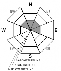
The avalanche danger will rise to MODERATE above treeline by this afternoon. Strong southerly winds and heavy snowfall are expected over the next 24 hours. Human triggered wind slab avalanches will be possible on steep, recently wind loaded slopes above 8,000ft on Mount Shasta. LOW avalanche danger exists near and below treeline.


Avalanche Problem 1: Wind Slab
-
Character ?

-
Aspect/Elevation ?
-
Likelihood ?CertainVery LikelyLikelyPossible
 Unlikely
 -
Size ?HistoricVery LargeLargeSmall

New snow and strong southerly winds have the potential to build fresh wind slabs by this afternoon. Wind slabs will likely be found above treeline on NW-N-NE-E aspects. A rise in avalanche danger with the formation of wind slabs will depend on snow accumulation. Watch for signs of wind transported snow like cornices, snowdrifts, and uneven snow surfaces. Avoid recently wind-loaded slopes that are 35 degrees and steeper.
Forecast Discussion
Another wet storm with high freezing levels will begin this morning. Heightened avalanche conditions are expected on steep leeward slopes and terrain features above treeline. Be sure to monitor conditions as they change throughout the day. If the forecast verifies, human-triggered wind slab avalanches will be possible by this afternoon. Snowfall and and gusty winds will also make for challenging travel conditions and poor visibility in the backcountry.
Recent Observations
The weekend finished off with partly cloudy skies and calm conditions. A tour up Avalanche Gulch yesterday confirmed that icefall and rockfall were very active on Casaval Ridge, the Trinity Chutes, and Redbanks. A large rock peeled off of Casaval ridge and made it all the way down climber’s gully to the 8,500ft level. Icefall was steady throughout the day. No recent avalanches or signs of unstable snow were observed. Firm and chalky snow surfaces made for fast, groomer-like skiing between 10,500-8,000ft. Above, it was icy and variable, and below, ski quality was very poor.

Weather and Current Conditions
Weather Summary
An upper level trough of low-pressure will bring moisture to northern California today. Rain and snow are expected with highs in the mid 30’s to low 40’s. Very strong southerly winds will accompany this storm. Freezing levels will be near 6,000ft today and will rise to 7,000ft overnight and into tomorrow. The advisory area looks to receive 1.6 inches of water over the next 48 hours. The bulk of precipitation will come today and tonight. At the 7,000ft level, 3-6 inches of wet snow is possible for today, with 1-2 inches expected overnight. Twice that amount of snow is possible for terrain 9,000ft and above by tomorrow morning. Unstable weather will continue through Thursday.
-------------------------
THIS SEASON PRECIPITATION for MT SHASTA CITY: Since October 1st (the wet season), we have received 7.19 inches of water, normal is 16.86 inches, putting us at 43% of normal. For the month of January and 2018, we have received 1.36 inches of water, normal is 1.65 inches, which is 82% of normal. Mount Shasta finished off 2017 with 44.82 inches of water; normal observed value is 43.21, which is 103% of normal.
Always check the weather before you attempt to climb Mount Shasta. Further, monitor the weather as you climb. Becoming caught on the mountain in any type of weather can compromise life and limb. Be prepared.
24 Hour Weather Station Data @ 4:00 AM
| Weather Station | Temp (°F) | Wind (mi/hr) | Snow (in) | Comments | ||||||||
|---|---|---|---|---|---|---|---|---|---|---|---|---|
| Cur | Min | Max | Avg | Avg | Max Gust | Dir | Depth | New | Water Equivalent | Settlement | ||
| Mt. Shasta City (3540 ft) | 44 | 26 | 50 | 42 | 3 | ESE | ||||||
| Sand Flat (6750 ft) | 33 | 25 | 38 | 32 | 11 | 0 | 0 | 0 | ||||
| Ski Bowl (7600 ft) | 27 | 27 | 37 | 32 | 19 | 0 | 0 | 0 | ||||
| Gray Butte (8000 ft) | 25 | 25 | 36 | 30 | 7 | 25 | SW | |||||
| Castle Lake (5870 ft) | 32 | 31 | 40 | 35 | 0 | 0 | 0 | |||||
| Mount Eddy (6509 ft) | 31 | 30 | 39 | 34 | 2 | 11 | SSE | 8 | 0 | 0 | ||
| Ash Creek Bowl (7250 ft) | station down | |||||||||||
| Ash Creek Ridge (7895 ft) | station down |
Two Day Mountain Weather Forecast
Produced in partnership with the Medford NWS
| For 7000 ft to 9000 ft | |||
|---|---|---|---|
|
Monday (4 a.m. to 10 p.m.) |
Monday Night (10 p.m. to 4 a.m.) |
Tuesday (4 a.m. to 10 p.m.) |
|
| Weather | Snow before 10am then rain and snow. Chance of precipitation 100%. | Rain and snow. Breezy. Chance of precipitation 100%. | Rain likely, possibly mixed with snow. Chance of precipitation 70%. |
| Temperature (°F) | 37 | 32 | 39 |
| Wind (mi/hr) | South 15-20 mph, gusting 30 mph | South/Southeast 15-20 mph, gusting 30 mph | South/Southeast 10-15 mph, gusting 20 mph |
| Precipitation SWE / Snowfall (in) | / 4-8 | / 1-3 | / <1 |
| For 9000 ft to 11000 ft | |||
| Monday | Monday Night | Tuesday | |
| Weather | Snow and windy. Chance of precipitation 100%. | Snow and windy. Chance of precipitation 100%. | Snow likely and windy. Chance of precipitation 70%. |
| Temperature (°F) | 28 | 25 | 25 |
| Wind (mi/hr) | South/Southwest 30-40 mph, gusting 60 mph | South/Southwest 5-9 | West/Southwest 25-35 mph, gusting 50 mph |
| Precipitation SWE / Snowfall (in) | / 5-9 | / 4-8 | / 1-3 |

