

You are here
Avalanche Advisory for 2018-01-10 06:24:25
- EXPIRED ON January 11, 2018 @ 6:24 amPublished on January 10, 2018 @ 6:24 am
- Issued by Aaron Beverly - Mount Shasta Avalanche Center
Bottom Line
LOW avalanche danger exists at all elevations. Isolated wind slabs may exist above 9000 ft on N-NE-E-SE-S aspects. Be aware of falling rime ice.


Avalanche Problem 1: Wind Slab
-
Character ?

-
Aspect/Elevation ?
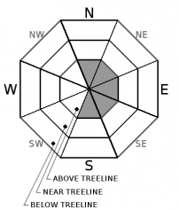
-
Likelihood ?CertainVery LikelyLikelyPossible
 Unlikely
 -
Size ?HistoricVery LargeLargeSmall

No wind slab problems were encountered yesterday on a tour up to 11,500 ft. New snow was bonding well with the old snow and no signs of instability were observed. However, moderate winds were transporting snow above 9000 ft - a sign of wind loading and wind slab formation. Wind loading is possible on N-NE-E-SE-S aspects.
LOW avalanche danger does not mean NO avalanche danger. Monitor changing conditions if ascending above 9000 ft. Look for cornice formation and shooting cracks in drifted snow as evidence of the wind slab problem. If in doubt, avoid convex slopes greater than 35 degrees. Look at connected terrain and consider the consequences of being carried down hill by a small avalanche.
Forecast Discussion
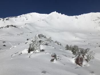
The snowpack below 9000 ft is locked up tight. Above, the wind slab problem is a diminishing concern, but one to take seriously. The rime ice plastered on the crags of ridges continues to be a hazard. Wind and warming weather can cause this ice to dislodge and plummet down upon unsuspecting climbers. Stay vigilant.
We are entering a holding pattern again as high pressure moves into the area. Be patient. Next week should bring a parade of strong Pacific storm systems with wet weather and snow levels down to 4000 ft.
Recent Observations
The end of Monday's storm brought rain and warm conditions turning the 5 inches of new snow at the Old Ski Bowl weather station to mush. Very wet (8-15% water) to wet (3-8% water) snow surfaces were encountered from 7600 to 8800 ft. With last night's freezing temperatures, expect a widespread crust below and near treeline.
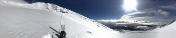
A tour from the Old Ski Bowl into Avalanche Gulch to 11,500 ft saw no signs of a wind slab problem. New snow was bonding well with itself and the old snow. Wind transport of snow was observed above 9000 ft. Look for new wind loading on E-SE-S aspects.
Snow was dry above 9800 ft. with the height of new snow (HN) ranging from 6-8 in (15-20 cm). Boot penetration was 6 in (15 cm). If you want the goods, this is where you'll need to go.

Weather and Current Conditions
Weather Summary
A couple of weak frontal systems will bring a chance of precipitation today and tomorrow with less than an inch of snow expected with each. Today, a skiff of snow may be seen as low 5000 ft. Snow levels later today and tomorrow are expected to be above 7000 ft. High pressure will set in for the weekend keeping things warm and dry until Monday when a return to winter weather is expected.
-------------------------
THIS SEASON PRECIPITATION for MT SHASTA CITY: Since October 1st (the wet season), we have received 7.74 inches of water, normal is 17.35 inches, putting us at 45% of normal. For the month of January, we have received 1.91 inches of water, normal is 2.14 inches, which is 90% of normal. And finally for the year of 2018, we received 1.91 inches of water, normal is 2.14 inches, putting us at 90% of normal.
Always check the weather before you attempt to climb Mount Shasta. Further, monitor the weather as you climb. Becoming caught on the mountain in any type of weather can compromise life and limb. Be prepared.
24 Hour Weather Station Data @ 6:00 AM
| Weather Station | Temp (°F) | Wind (mi/hr) | Snow (in) | Comments | ||||||||
|---|---|---|---|---|---|---|---|---|---|---|---|---|
| Cur | Min | Max | Avg | Avg | Max Gust | Dir | Depth | New | Water Equivalent | Settlement | ||
| Mt. Shasta City (3540 ft) | 36 | 36 | 49 | 43 | 2 | N | ||||||
| Sand Flat (6750 ft) | 27 | 27 | 38 | 32 | 10 | 1 | 0 | 0 | ||||
| Ski Bowl (7600 ft) | 27 | 23 | 39 | 30 | 24 | 1 | 0 | 1 | ||||
| Gray Butte (8000 ft) | 23 | 22 | 35 | 29 | 15 | 31 | NW | |||||
| Castle Lake (5870 ft) | 29 | 28 | 42 | 34 | 0 | 0 | 0 | |||||
| Mount Eddy (6509 ft) | 26 | 26 | 38 | 31 | 1 | 10 | SE | 0 | 0 | 0 | ||
| Ash Creek Bowl (7250 ft) | Station down | |||||||||||
| Ash Creek Ridge (7895 ft) | Station down |
Two Day Mountain Weather Forecast
Produced in partnership with the Medford NWS
| For 7000 ft to 9000 ft | |||
|---|---|---|---|
|
Wednesday (4 a.m. to 10 p.m.) |
Wednesday Night (10 p.m. to 4 a.m.) |
Thursday (4 a.m. to 10 p.m.) |
|
| Weather | Snow, mainly before 10am. Breezy. Chance of precipitation is 80%. | A slight chance of rain and snow. Mostly cloudy. Breezy. Chance of precipitation is 20%. | A 50 percent chance of rain. Mostly cloudy. Breezy. |
| Temperature (°F) | 35 | 33 | 37 |
| Wind (mi/hr) | Southwest 10-15 mph, gusting to 20 | Southwest 5-10 mph, gusting to 15 | South 10-20 mph, gusting to 25 |
| Precipitation SWE / Snowfall (in) | / <1 | / 0 | / 0 |
| For 9000 ft to 11000 ft | |||
| Wednesday | Wednesday Night | Thursday | |
| Weather | Snow, mainly before 10am. Wind chill values as low as -4. Windy. Chance of precipitation is 80%. | A 20 percent chance of snow. Mostly cloudy. Windy. | A 50 percent chance of snow. Mostly cloudy. |
| Temperature (°F) | 29 | 28 | 28 |
| Wind (mi/hr) | West 35-45 mph, gusting to 55 | West <1 | Southwest 40-50 mph, gusting 60 mph |
| Precipitation SWE / Snowfall (in) | / <1 | / 0 | / <1 |

