

You are here
Avalanche Advisory for 2018-01-22 06:52:22
- EXPIRED ON January 23, 2018 @ 6:52 amPublished on January 22, 2018 @ 6:52 am
- Issued by Andrew Kiefer - Mt Shasta Avalanche Center
Bottom Line
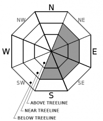
MODERATE avalanche danger exists near and above treeline. Fresh wind slabs are a concern on S-SE-E-NE-N aspects above 8,000 ft. Human triggered avalanches are possible while natural avalanches are unlikely. The avalanche danger is LOW below treeline.


Avalanche Problem 1: Wind Slab
-
Character ?

-
Aspect/Elevation ?
-
Likelihood ?CertainVery LikelyLikelyPossible
 Unlikely
 -
Size ?HistoricVery LargeLargeSmall

Recent snowfall and westerly winds have formed wind slabs 1-3 ft thick near and above treeline on S-SE-E-NE-N aspects. Human triggered wind slab avalanches are possible on wind loaded slopes 35 degrees and steeper above 8,000ft. Watch for evidence of wind loading like blowing snow, cornices, textured snow surfaces, and hollow sounding snow. Fresh wind slabs may continue to form throughout the day.
Forecast Discussion
We hit the low end of the forecasted snow totals yesterday and overnight. The new snow came in cold and light, with snow down to town level, finally making it feel like winter here in Mount Shasta. A break in storms is expected today before an atmospheric river event will begin late tomorrow night. The next storm is looking promising. For today, fresh wind slabs are a concern on steep leeward slopes near and above treeline. Also, keep in mind that many shallow snowpack hazards still exist below treeline.
Recent Observations
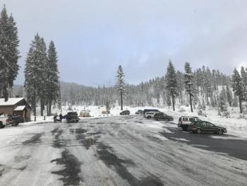
Snowfall began yesterday just after 9AM. Storm totals range from 10-15 cm (4-6 in) in terrain 6,000 ft and above. This storm allowed snow to accumulate in Mount Shasta City for the first time all season with 7-10 cm (3-4 in) of snow on the ground as of 6AM this morning. The winds blew 15-20 mph out of the northwest yesterday morning, and shifted to the west/southwest yesterday afternoon and overnight.
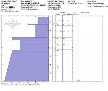
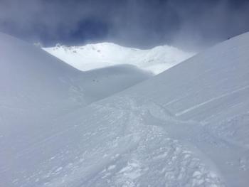
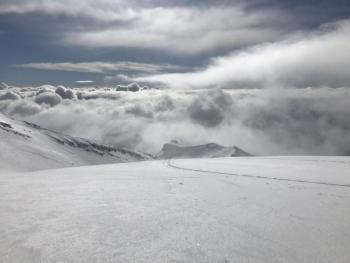
A tour up Green Butte Ridge to lower Sun Bowl yesterday revealed a very shallow snowpack below treeline, and less wind loading than anticipated near and above treeline as of 3PM. The height of snow ranged from 50-120 cm (20-40 in) from 7,000-8,500 ft, and only 5-7 cm (2-3 in) of snow had accumulated at this point in the day. Drifts of snow and shallow wind slabs were beginning to develop in near treeline areas on south and east aspects. A ski cut on a small southeast facing wind loaded test slope at 8,000 ft produced minor cracking in a 15-20 cm (6-8 in) shallow wind slab. Plenty of snow was available for transport. Visibility above treeline was limited.
Weather and Current Conditions
Weather Summary
Light snow showers will continue this morning before gradually tapering off after 10AM. Highs will reach the low 30s and westerly winds will blow before shifting southwest by tomorrow. A break in precipitation is expected this afternoon and tonight. A front will arrive on Tuesday, and it is set to bring significant precipitation. Heavy snowfall will begin after 10PM tomorrow night, and over 1 inch of water is forecast for the advisory area by Wednesday afternoon. Snow levels should remain at or below 4,000 ft. Another storm should follow on Thursday, as a trough of low pressure will bring colder than normal temperatures and low snow levels. Precipitation should continue through the end of the week.
24 Hour Weather Station Data @ 6:00 AM
| Weather Station | Temp (°F) | Wind (mi/hr) | Snow (in) | Comments | ||||||||
|---|---|---|---|---|---|---|---|---|---|---|---|---|
| Cur | Min | Max | Avg | Avg | Max Gust | Dir | Depth | New | Water Equivalent | Settlement | ||
| Mt. Shasta City (3540 ft) | 34 | 28 | 35 | 32 | 4 | SE | ||||||
| Sand Flat (6750 ft) | 24 | 22 | 25 | 24 | 20 | 4 | 0 | |||||
| Ski Bowl (7600 ft) | 21 | 19 | 22 | 20 | 35 | 6 | .32 | 0 | ||||
| Gray Butte (8000 ft) | 20 | 16 | 20 | 18 | 15 | 37 | WSW | |||||
| Castle Lake (5870 ft) | 26 | 23 | 27 | 25 | 5 | 3 | 0 | |||||
| Mount Eddy (6509 ft) | 24 | 20 | 27 | 24 | 1 | 16 | S | 21 | 5 | 0 | ||
| Ash Creek Bowl (7250 ft) | station down | |||||||||||
| Ash Creek Ridge (7895 ft) | station down |
Two Day Mountain Weather Forecast
Produced in partnership with the Medford NWS
| For 7000 ft to 9000 ft | |||
|---|---|---|---|
|
Monday (4 a.m. to 10 p.m.) |
Monday Night (10 p.m. to 4 a.m.) |
Tuesday (4 a.m. to 10 p.m.) |
|
| Weather | Chance of snow showers before 10am. Mostly cloudy. | Mostly cloudy | Snow likely, mainly after 4pm. Mostly cloudy. |
| Temperature (°F) | 30 | 25 | 31 |
| Wind (mi/hr) | Southwest 5-15 mph | Southeast 5-10 mph | South 15-20 mph |
| Precipitation SWE / Snowfall (in) | / < 1 | / 0 | / 1-2 |
| For 9000 ft to 11000 ft | |||
| Monday | Monday Night | Tuesday | |
| Weather | Chance of snow showers before 10am. Mostly cloudy. Wind chill values as low as -10 degrees F. | Mostly cloudy. Wind chill values as low as -1 degree F. | Snow likely, mainly after 4pm. Mostly Cloudy and windy. Wind chill values as low as -5. |
| Temperature (°F) | 19 | 19 | 20 |
| Wind (mi/hr) | West 30-40 mph, gusting 50+ mph | West < 1 | Southwest 30-40 mph |
| Precipitation SWE / Snowfall (in) | / < 1 | / 0 | / 1-3 |
Season Precipitation for Mount Shasta City
| Period | Measured (in) | Normal (in) | Percent of Normal (%) |
|---|---|---|---|
| From Oct 1, 2023 (the wet season) | 9.07 | 20.13 | 45 |
| Month to Date (since Apr 1, 2024) | 3.24 | 4.92 | 66 |
| Year to Date (since Jan 1, 2024) | 3.24 | 4.92 | 66 |

