

You are here
Avalanche Advisory for 2018-01-31 04:03:37
- EXPIRED ON February 1, 2018 @ 4:03 amPublished on January 31, 2018 @ 4:03 am
- Issued by Aaron Beverly - Mount Shasta Avalanche Center
Bottom Line
Avalanche danger is LOW. Wind slabs may be found in isolated areas above 9000 ft on SE-E-NE slopes steeper than 35 degrees. Watch out for falling rime ice above treeline.


Avalanche Problem 1: Wind Slab
-
Character ?

-
Aspect/Elevation ?
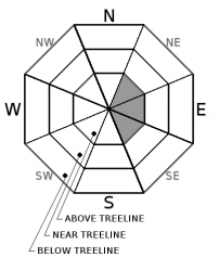
-
Likelihood ?CertainVery LikelyLikelyPossible
 Unlikely
 -
Size ?HistoricVery LargeLargeSmall

Natural and human triggered wind slabs are unlikely. Small wind slabs may be found in isoloated areas on SE-E-NE aspects above 9000 ft. Avoid wind loaded slopes steeper than 35 degrees. Check for the presence of wind slabs by looking for cornices, blowing snow, wind pillows, and hollow sounding snow.
Forecast Discussion
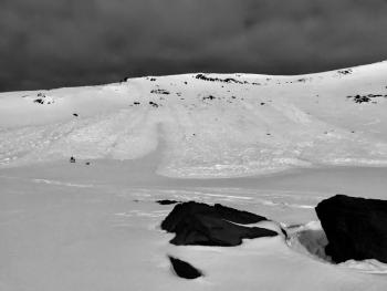
Alpine rock features on Mount Shasta are covered with rime ice. Warming weather may cause this ice to dislodge and fall. Be careful below Casaval Ridge, the Trinity Chutes, and Redbanks. Wear a helmet and stay vigilant.
Recent Observations
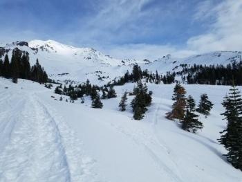
Temperatures have been above freezing (35-43 °F) at 8000 ft for the last 24 hours. Moderate to strong northwest winds (21-34 mph) have likely kept snow surfaces cool and unchanged. Expect variable snow surfaces below 9500 ft. Skiers found favorable conditions above 10,000 ft yesterday. No new avalanches have been seen since Saturday.
Weather and Current Conditions
Weather Summary
A weak warm front will bring a slight chance of precipitation tomorrow morning. The high pressure ridge off the coast shows no signs of breaking in the coming week. Expect warm and dry conditions to prevail for the next 10 days.
One month and three month climate outlooks indicate normal precipitation and temperatures providing some hope that winter will return to the area.
24 Hour Weather Station Data @ 5:00 AM
| Weather Station | Temp (°F) | Wind (mi/hr) | Snow (in) | Comments | ||||||||
|---|---|---|---|---|---|---|---|---|---|---|---|---|
| Cur | Min | Max | Avg | Avg | Max Gust | Dir | Depth | New | Water Equivalent | Settlement | ||
| Mt. Shasta City (3540 ft) | 35 | 30 | 57 | 43 | 1 | N | ||||||
| Sand Flat (6750 ft) | 38 | 37 | 45 | 40 | 24 | 0 | 0 | 1 | ||||
| Ski Bowl (7600 ft) | 39 | 37 | 47 | 40 | 44 | 0 | 0 | 1 | ||||
| Gray Butte (8000 ft) | 37 | 35 | 43 | 38 | 28 | 55 | NW | |||||
| Castle Lake (5870 ft) | 38 | 37 | 52 | 42 | 12 | 0 | 1 | |||||
| Mount Eddy (6509 ft) | 37 | 34 | 48 | 40 | 2 | 11 | SSW | 25 | 0 | 1 | ||
| Ash Creek Bowl (7250 ft) | station down | |||||||||||
| Ash Creek Ridge (7895 ft) | station down |
Two Day Mountain Weather Forecast
Produced in partnership with the Medford NWS
| For 7000 ft to 9000 ft | |||
|---|---|---|---|
|
Wednesday (4 a.m. to 10 p.m.) |
Wednesday Night (10 p.m. to 4 a.m.) |
Thursday (4 a.m. to 10 p.m.) |
|
| Weather | Mostly sunny. | Mostly cloudy. | Mostly cloudy. |
| Temperature (°F) | 47 | 37 | 50 |
| Wind (mi/hr) | West 5 mph | West/Northwest 5 mph | West/Northwest 5 mph |
| Precipitation SWE / Snowfall (in) | / 0 | / 0 | / 0 |
| For 9000 ft to 11000 ft | |||
| Wednesday | Wednesday Night | Thursday | |
| Weather | Mostly sunny. Windy | A 10 percent chance of snow after 4 a.m. Mostly cloudy. Windy. | A 20 percent chance of snow before 10 a.m. Windy. |
| Temperature (°F) | 33 | 30 | 33 |
| Wind (mi/hr) | West/Northwest 25-30 mph, gusts to 40 | West 0 | Northwest 25-30 mph, gusts to 40 |
| Precipitation SWE / Snowfall (in) | / 0 | / 0 | / 0 |
Season Precipitation for Mount Shasta City
| Period | Measured (in) | Normal (in) | Percent of Normal (%) |
|---|---|---|---|
| From Oct 1, 2023 (the wet season) | 10.11 | 22.06 | 46 |
| Month to Date (since Apr 1, 2024) | 4.28 | 6.85 | 62 |
| Year to Date (since Jan 1, 2024) | 4.28 | 6.85 | 62 |

