

You are here
Avalanche Advisory for 2018-02-20 07:00
- EXPIRED ON February 21, 2018 @ 7:00 amPublished on February 20, 2018 @ 7:00 am
- Issued by Andrew Kiefer - Mt Shasta Avalanche Center
Bottom Line
Avalanche danger is LOW and NORMAL CAUTION is advised. Firm and icy snow surfaces are widespread and shallow snowpack hazards exist. Minor wind loading has occurred on S-SE-E aspects between 7,500-9,000 ft. Watch for unstable snow on isolated terrain features.


Avalanche Problem 1: Normal Caution
-
Character ?

-
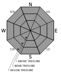
Aspect/Elevation ?
-
Likelihood ?CertainVery LikelyLikelyPossible
 Unlikely
 -
Size ?HistoricVery LargeLargeSmall

NORMAL CAUTION means:
- Watch for isolated slabs.
- Ski and ride one at a time in avalanche terrain.
- Don't regroup in run out zones.
- Basic avalanche rescue skills are essential in avalanche terrain.
Isolated slabs are related to wind and terrain. Look for areas of drifting snow. This will occur on the lee side of ridges, in terrain depressions, on convex terrain features, and in the lee of isolated bands of trees.
Forecast Discussion
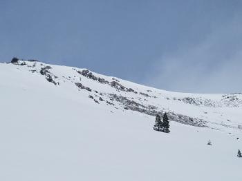
Cold temperatures and wind chill values well below 0° F will continue today. Strong winds have stripped away the recent snow in terrain above 9,000 ft where the old and icy snow surface is exposed. Arresting a fall on a steep slope above treeline would be difficult in these conditions. Drifts of snow, miniature cornice formations and inconsequential wind slabs were found on southeasterly aspects between 7,500-9,000 ft yesterday. Shallow wind loading occurred in isolated areas but did not seem to pose a significant avalanche concern. Regardless, watch for unstable snow on obviously wind loaded terrain features today.
Recent Observations
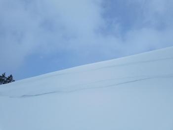
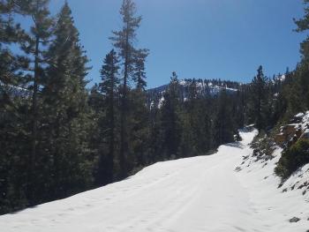
A ride to the Old Ski Bowl yesterday revealed 2-3 inches of new snow between 7,000-9,000 ft. Above, evidence of the new snow was hard to find and snow surfaces were very firm and icy. Above 9,000 ft, the new snow has been stripped away and transported to lower elevations. Between 7,500-9,000 ft, drifts of snow and small cornice formations 12-18 inches deep were found in isolated areas on E and SE aspects. Inconsequential and small wind slabs 2-4 inches thick were found in the same isolated areas. It was surprising to see the amount of wind loading that occurred between 7,500-9,000 ft given the amount of snow that fell. Cornice formations on a small test slope were easy to break with the weight of a person (video). Active wind loading was not observed yesterday.
Weather and Current Conditions
Weather Summary
Expect increasing cloud cover throughout the day. Temperatures will reach the mid 20s at 6,000 ft while above treeline highs will be in the teens. Northwest winds will continue with gusts up to 25 mph above 8,000 ft. A low-pressure system will impact the Pacific Northwest late tonight through Thursday. This storm will give Mount Shasta another chance for light snow showers down to town level with .04 inches of water and .5-1 inches of snow expected by Thursday.
24 Hour Weather Station Data @ 6:00 AM
| Weather Station | Temp (°F) | Wind (mi/hr) | Snow (in) | Comments | ||||||||
|---|---|---|---|---|---|---|---|---|---|---|---|---|
| Cur | Min | Max | Avg | Avg | Max Gust | Dir | Depth | New | Water Equivalent | Settlement | ||
| Mt. Shasta City (3540 ft) | 18 | 18 | 35 | 26 | 5 | N | ||||||
| Sand Flat (6750 ft) | 11 | 11 | 12 | 12 | 18 | 0 | 0 | .5 | ||||
| Ski Bowl (7600 ft) | 6.5 | 4 | 14.5 | 8.5 | 40 | 0 | 0.03 | .5 | ||||
| Gray Butte (8000 ft) | 5.5 | 5 | 15 | 8 | 6 | 31 | SE | |||||
| Castle Lake (5870 ft) | 9 | 9 | 22.5 | 14.5 | 7.5 | 0 | .5 | |||||
| Mount Eddy (6509 ft) | 7 | 6.5 | 15 | 10.5 | 3 | 14 | SE | 22.5 | 0 | .5 | ||
| Ash Creek Bowl (7250 ft) | station down | |||||||||||
| Ash Creek Ridge (7895 ft) | station down |
Two Day Mountain Weather Forecast
Produced in partnership with the Medford NWS
| For 7000 ft to 9000 ft | |||
|---|---|---|---|
|
Tuesday (4 a.m. to 10 p.m.) |
Tuesday Night (10 p.m. to 4 a.m.) |
Wednesday (4 a.m. to 10 p.m.) |
|
| Weather | Partly sunny | Mostly cloudy then 50% chance of snow showers. | A 50% chance of snow before 10am, then a chance of snow showers, mainly after 4pm. Partly sunny. |
| Temperature (°F) | 22 | 13 | 25 |
| Wind (mi/hr) | W/NW 5-10 mi/hr | S 5-10 mi/hr | NW 5 mi/hr |
| Precipitation SWE / Snowfall (in) | / 0 | / < 1 | / 1 |
| For 9000 ft to 11000 ft | |||
| Tuesday | Tuesday Night | Wednesday | |
| Weather | Cold and partly sunny. Wind chill values as low as -25. | 50% chance of snow showers then partly cloudy. Wind chill values as low as -19. | A chance of snow before 10am, then a slight chance of snow showers after 10am. Partly sunny and cold. Wind chill values as low as -20. |
| Temperature (°F) | 2 | 2 | 3 |
| Wind (mi/hr) | W/NW 15-20 mi/hr | W 0 | N 15-20 mi/hr |
| Precipitation SWE / Snowfall (in) | / 0 | / < 1 | / 1 |
Season Precipitation for Mount Shasta City
| Period | Measured (in) | Normal (in) | Percent of Normal (%) |
|---|---|---|---|
| From Oct 1, 2023 (the wet season) | 10.20 | 27.05 | 38 |
| Month to Date (since Apr 1, 2024) | 0.09 | 4.78 | 2 |
| Year to Date (since Jan 1, 2024) | 4.37 | 11.84 | 37 |

