

You are here
Avalanche Advisory for 2018-02-26 06:38
- EXPIRED ON February 27, 2018 @ 6:38 amPublished on February 26, 2018 @ 6:38 am
- Issued by Andrew Kiefer - Mt Shasta Avalanche Center
Bottom Line
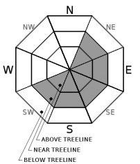
Fresh wind slabs 1-2 feet thick may exist on SW-S-SE-E-NE aspects near and above treeline. Human triggered wind slab avalanches are possible while natural avalanches are unlikely. The avalanche danger is MODERATE near and above treeline and LOW below treeline.


Avalanche Problem 1: Wind Slab
-
Character ?

-
Aspect/Elevation ?
-
Likelihood ?CertainVery LikelyLikelyPossible
 Unlikely
 -
Size ?HistoricVery LargeLargeSmall

New snow and northerly winds have created fresh winds slabs near and above treeline on SW-S-SE-E-NE aspects. Wind slabs could be human triggered on leeward slopes and terrain features 35 degrees and steeper. Watch for blowing snow, cornices, textured snow surfaces and drifts of snow as evidence that wind loading has occurred. With just a few inches of low-density snow falling on slick and icy old snow surfaces, the new snow may have been stripped off many slopes above treeline and transported to lower elevations. Be especially careful of obviously wind-loaded slopes between 7,500-9,000 ft.
Forecast Discussion
Snow totals from the past 24 hours range from 1-4 inches throughout the advisory area. Northwest winds have created shallow wind slabs and loaded leeward slopes, gullies and terrain depressions near and above treeline. Most likely, the new snow has been stripped away from many slopes above 9,000 ft on Mount Shasta leaving widespread firm and icy snow surfaces. Shallow snowpack hazards still exist and the new snow has just barely covered many obstacles and patches of bare ground.
Recent Observations
The Old Ski Bowl weather station recorded .13 inches of SWE (snow water equivalent) and 4 inches of new snow. Precipitation began at 10 pm last night. Winds at Grey Butte shifted from the NW to SW to W overnight with a max wind gust of 65 mph. No signs of unstable snow or avalanches were observed during a tour to Sun Bowl yesterday. The snow from the last storm has settled 2-3 inches below treeline, and has been almost completely stripped away from most slopes near and above treeline. Unreactive and isolated winds slabs up to 8 inches thick were found on SE aspects near treeline. A small cornice still exists at the top of Sun Bowl. Many avalanche path start zones including Sun Bowl and Powder Bowl are scoured down to bare ground. Ridgelines and exposed terrain features are as well. The snowpack is 1-3 ft deep below treeline with many bare patches.
Weather and Current Conditions
Weather Summary
Light snow showers will continue through 10 am this morning with an additional .5 inches of snow possible. Westerly winds will shift to the north/northeast blowing 20-30 mph above treeline. Clouds will gradually break down throughout the day. Tonight will be clear and cold. Sunny skies are expected tomorrow. A potent winter storm under southwest flow will impact northern California Wednesday through Friday bringing heavy snowfall.
24 Hour Weather Station Data @ 6:00 AM
| Weather Station | Temp (°F) | Wind (mi/hr) | Snow (in) | Comments | ||||||||
|---|---|---|---|---|---|---|---|---|---|---|---|---|
| Cur | Min | Max | Avg | Avg | Max Gust | Dir | Depth | New | Water Equivalent | Settlement | ||
| Mt. Shasta City (3540 ft) | 32 | 27 | 47 | 35.5 | 1 | N | ||||||
| Sand Flat (6750 ft) | station down | |||||||||||
| Ski Bowl (7600 ft) | 16.5 | 16.5 | 30.5 | 22.5 | 43 | 3 | 0.15 | 3 | ||||
| Gray Butte (8000 ft) | 16.5 | 16.5 | 25.5 | 20.5 | 20 | 64 | W | |||||
| Castle Lake (5870 ft) | 23 | 22.5 | 44 | 28.5 | 9.5 | 2 | 2 | |||||
| Mount Eddy (6509 ft) | 20.5 | 20 | 34 | 26 | 2 | 14 | SSE | 27 | 3 | 1 | ||
| Ash Creek Bowl (7250 ft) | station down | |||||||||||
| Ash Creek Ridge (7895 ft) | station down |
Two Day Mountain Weather Forecast
Produced in partnership with the Medford NWS
| For 7000 ft to 9000 ft | |||
|---|---|---|---|
|
Monday (4 a.m. to 10 p.m.) |
Monday Night (10 p.m. to 4 a.m.) |
Tuesday (4 a.m. to 10 p.m.) |
|
| Weather | A 40% chance of snow showers, mainly before 10am. Partly sunny, | Mostly clear. Wind chill values as low as -11. | Mostly sunny. Wind chill values as low as -10. |
| Temperature (°F) | 17 | 15 | 27 |
| Wind (mi/hr) | NW 5-10 mi/hr | N 10-15 mi/hr | N 10-15 mi/hr |
| Precipitation SWE / Snowfall (in) | / .5 | / 0 | / 0 |
| For 9000 ft to 11000 ft | |||
| Monday | Monday Night | Tuesday | |
| Weather | A 40% chance of snow showers, mainly before 10am. Partly sunny and cold. Wind chill values as low as -29. | Mostly clear and cold. Wind chill values as low as -34. | Mostly sunny. Windy. Wind chill values as low as -31. |
| Temperature (°F) | 1 | -1 | 15 |
| Wind (mi/hr) | N/NE 20-30 mi/hr | N/NE .5 | N 40-50 mi/hr |
| Precipitation SWE / Snowfall (in) | / .5 | / 0 | / 0 |
Season Precipitation for Mount Shasta City
| Period | Measured (in) | Normal (in) | Percent of Normal (%) |
|---|---|---|---|
| From Oct 1, 2023 (the wet season) | 10.28 | 28.69 | 36 |
| Month to Date (since Apr 1, 2024) | 0.17 | 6.42 | 3 |
| Year to Date (since Jan 1, 2024) | 4.45 | 13.48 | 33 |

