

You are here
Avalanche Advisory for 2018-03-08 06:00
- EXPIRED ON March 9, 2018 @ 6:00 amPublished on March 8, 2018 @ 6:00 am
- Issued by Nick Meyers - Shasta-Trinity National Forest
Bottom Line
Overnight, a couple inches of new snow accompanied by strong S/SW winds impacted higher terrain within the forecast area. New snow is available for transport and fresh wind slabs will form on leeward northerly and easterly terrain, near and above treeline. Periods of snow and continued high winds are expected today. Active wind loading will occur and human triggered wind slabs are possible.


Avalanche Problem 1: Wind Slab
-
Character ?

-
Aspect/Elevation ?
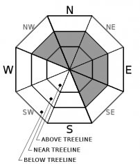
-
Likelihood ?CertainVery LikelyLikelyPossible
 Unlikely
 -
Size ?HistoricVery LargeLargeSmall

Look for blowing snow today, note where it's going and use caution on those slopes. Wind slabs can vary in size and depth. Wind slabs can be recognized by the appearance of the snow surface, changes in snow hardness, hollow drum-like sounds and/or shooting cracks. Identify specific terrain features of concern such as leeward aspects of ridgelines and steep, upper edges of bowls. Wind slabs are best managed by recognizing and avoiding areas where wind slabs have formed.
Forecast Discussion
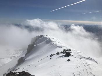
If you plan on heading up above treeline today, be prepared for strong winds, wind chill and developing wind slabs on northerly and easterly aspects. Unsettled weather will continue through Friday.
Recent Observations
On Mount Shasta in the last 24 hours:
- 2-4 inches of new snow fell overnight (.27 inches water from 2100 to 0300 hours)
- Winds have organized out of the southwest, averaging 10-20 mi/hr with gusts 30-40 mi/hr
- Temperatures have ranged from 24 to 35 deg F
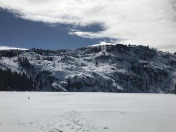
Castle Lake:
- 2+ feet of snow on the ground surrounding Castle Lake
- Lake is frozen

Weather and Current Conditions
Weather Summary
A low pressure system moves inland today. Gusty winds are the main impact. Light rain and snow showers should persist through Friday. Several inches of snow can be expected above 6,000 feet by the weekend. The heaviest precipitation with this system will be focused on the southern and western slopes of higher terrain. The extended forecast shows a period of mainly dry, mild weather with temperatures above normal.
24 Hour Weather Station Data @ 4:00 AM
| Weather Station | Temp (°F) | Wind (mi/hr) | Snow (in) | Comments | ||||||||
|---|---|---|---|---|---|---|---|---|---|---|---|---|
| Cur | Min | Max | Avg | Avg | Max Gust | Dir | Depth | New | Water Equivalent | Settlement | ||
| Mt. Shasta City (3540 ft) | 40 | 35 | 54 | 42.5 | 3 | ESE | ||||||
| Sand Flat (6750 ft) | station down | |||||||||||
| Ski Bowl (7600 ft) | 25 | 25 | 39.5 | 32 | 60 | 4 | 0.27 | 2.5 | ||||
| Gray Butte (8000 ft) | 26.5 | 25 | 36 | 30.5 | 10 | 31 | SSE | |||||
| Castle Lake (5870 ft) | 30 | 30 | 51.5 | 37.5 | 28 | 3 | 2.5 | |||||
| Mount Eddy (6509 ft) | 25.5 | 25.5 | 43 | 34 | 2 | 18 | SSW | 46 | 3 | 2.5 | ||
| Ash Creek Bowl (7250 ft) | station down | |||||||||||
| Ash Creek Ridge (7895 ft) | station down |
Two Day Mountain Weather Forecast
Produced in partnership with the Medford NWS
| For 7000 ft to 9000 ft | |||
|---|---|---|---|
|
Thursday (4 a.m. to 10 p.m.) |
Thursday Night (10 p.m. to 4 a.m.) |
Friday (4 a.m. to 10 p.m.) |
|
| Weather | Windy. Widespread rain and snow showers. Chance of precipitation 80%. Snow level 5,500 feet. | Breezy, cloudy. Rain and snow showers. Chance of precipitation 80%. Snow level at 5,900 feet. | Rain and snow showers. Chance of precipitation 80%. Snow level at 6,000 feet. |
| Temperature (°F) | 34 | 34 | 36 |
| Wind (mi/hr) | S 10-20 mi/hr | S 10-15 mi/hr | S 5-10 mi/hr |
| Precipitation SWE / Snowfall (in) | / 1-2 | / 3-5 | / 2-3 |
| For 9000 ft to 11000 ft | |||
| Thursday | Thursday Night | Friday | |
| Weather | Snow showers and windy. Chance of precipitation 90%. | Snow showers and windy. Chance of precipitation 100%. | Show showers and windy. Chance of precipitation 100%. |
| Temperature (°F) | 18 | 18 | 19 |
| Wind (mi/hr) | SW 40-50 mi/hr | W 2-4 | W 10-20 mi/hr |
| Precipitation SWE / Snowfall (in) | / 2-4 | / 3-5 | / 2-4 |
Season Precipitation for Mount Shasta City
| Period | Measured (in) | Normal (in) | Percent of Normal (%) |
|---|---|---|---|
| From Oct 1, 2023 (the wet season) | 12.39 | 31.23 | 40 |
| Month to Date (since Apr 1, 2024) | 1.50 | 1.73 | 87 |
| Year to Date (since Jan 1, 2024) | 6.56 | 16.02 | 41 |

