

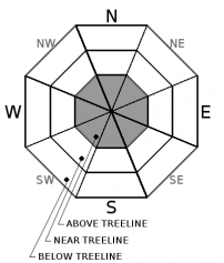
You are here
Avalanche Advisory for 2018-03-09 05:58
- EXPIRED ON March 10, 2018 @ 5:58 amPublished on March 9, 2018 @ 5:58 am
- Issued by Nick Meyers - Shasta-Trinity National Forest
Bottom Line
Three to four inches of moist snow has fallen on top of our old storm snow. Below and near treeline, the new snow is posing few concerns and LOW avalanche danger exists. Shallow buried objects still lurk.
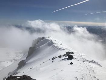
Above treeline terrain has not been observed due to poor visibility. MODERATE danger remains above treeline where temperature and snow has been colder and dryer. Wind slabs may exist on leeward terrain along ridgelines and near the tops of bowls.


Avalanche Problem 1: Wind Slab
-
Character ?

-
Aspect/Elevation ?
-
Likelihood ?CertainVery LikelyLikelyPossible
 Unlikely
 -
Size ?HistoricVery LargeLargeSmall

If you get a break in the weather today and get above treeline, scan the terrain for past and/or present signs of blowing snow. Wind slabs can vary in size and depth. Wind slabs can be recognized by the appearance of the snow surface, changes in snow hardness, hollow drum-like sounds and/or shooting cracks. Identify specific terrain features of concern such as leeward aspects of ridgelines and steep, upper edges of bowls.
Forecast Discussion
Warm temperatures and moist snow has kept avalanche danger LOW for most elevations and aspects. The only uncertainty is for above treeline, alpine terrain on Mount Shasta where we have a lack of observations. Our hunch is that the new snow has pasted onto old snow surfaces well. Use normal caution and watch for isolated areas in steep terrain where a small wind slab might linger.
Recent Observations
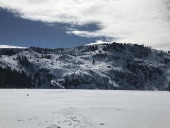
Yesterday, a soggy tour was made on and around the Gray Butte area. Near steady precipitation was experienced for most of the day. Snow levels began near 5,000 feet and slowly crept up over the day. It was raining at the Ski Park parking lot by late afternoon (5,500 ft). Up on Gray Butte, 2-4 inches of moist, new snow had accumulated on top of the old, settled storm snow. We were expecting winds to be blowing harder, but they were fairly light for the time we were up there. No wind slabs, blowing snow, recent avalanches or other signs of instability was observed during our tour. Visibility was poor and we could not catch a peep at Mount Shasta, so it's unknown how things look above treeline.
In the last 24 hours at 8,000 feet on Mount Shasta:
- 2-4 inches of new snow / .42 inches water
- Winds have averaged 11 mi/hr out of the W/SW
- Temperatures have ranged from 20 to 27 deg F at 8,000 feet

Weather and Current Conditions
Weather Summary
Precipitation stretches across Northern California and Southern Oregon this morning. This frontal boundary will remain stationary through much of the morning before it begins to drift south and east. Wind and precipitation will dissipate this afternoon/tonight. By midnight, we should be done. Saturday looks dry. A weak short wave ridge builds over the area Sunday and this will produce dry and unseasonably warm weather, in some areas a solid 10 degrees above normal. Next week, model guidance remains fairly consistent with a period of wet weather starting sometime near Tuesday.
24 Hour Weather Station Data @ 4:00 AM
| Weather Station | Temp (°F) | Wind (mi/hr) | Snow (in) | Comments | ||||||||
|---|---|---|---|---|---|---|---|---|---|---|---|---|
| Cur | Min | Max | Avg | Avg | Max Gust | Dir | Depth | New | Water Equivalent | Settlement | ||
| Mt. Shasta City (3540 ft) | 40 | 35 | 54 | 42.5 | 3 | ESE | ||||||
| Sand Flat (6750 ft) | station down | |||||||||||
| Ski Bowl (7600 ft) | 27 | 21 | 28.5 | 26.5 | 62 | 3 | 0.33 | 0.2 | ||||
| Gray Butte (8000 ft) | 26.5 | 20 | 27.5 | 25.5 | 11 | 37 | W | |||||
| Castle Lake (5870 ft) | 32.5 | 28 | 35 | 32 | 27 | 2 | 2 | |||||
| Mount Eddy (6509 ft) | 30.5 | 25 | 37.5 | 31 | 2 | 12 | SSE | 41 | 2 | 4 | ||
| Ash Creek Bowl (7250 ft) | station down | |||||||||||
| Ash Creek Ridge (7895 ft) | station down |
Two Day Mountain Weather Forecast
Produced in partnership with the Medford NWS
| For 7000 ft to 9000 ft | |||
|---|---|---|---|
|
Friday (4 a.m. to 10 p.m.) |
Friday Night (10 p.m. to 4 a.m.) |
Saturday (4 a.m. to 10 p.m.) |
|
| Weather | Rain and snow. Snow level near 5,700 feet | Mostly cloudy, slight chance of rain and snow. Snow level near 5,800 feet. | Partly cloudy |
| Temperature (°F) | 39 | 30 | 43 |
| Wind (mi/hr) | SW 5-10 mi/hr | S 0-5 mi/hr | SE 5-10 mi/hr |
| Precipitation SWE / Snowfall (in) | / 1-3 | / 0-.5 | / 0 |
| For 9000 ft to 11000 ft | |||
| Friday | Friday Night | Saturday | |
| Weather | Snow showers and breezy | Mostly cloudy, slight chance of snow. | Partly cloudy |
| Temperature (°F) | 22 | 21 | 25 |
| Wind (mi/hr) | W 10-20 mi/hr | W 1-3 | SW 10-20 mi/hr |
| Precipitation SWE / Snowfall (in) | / 1-3 | / 0-.5 | / 0 |
Season Precipitation for Mount Shasta City
| Period | Measured (in) | Normal (in) | Percent of Normal (%) |
|---|---|---|---|
| From Oct 1, 2023 (the wet season) | 12.41 | 31.46 | 39 |
| Month to Date (since Apr 1, 2024) | 1.52 | 1.96 | 78 |
| Year to Date (since Jan 1, 2024) | 6.58 | 16.25 | 40 |

