

You are here
Avalanche Advisory for 2018-03-18 06:25
- EXPIRED ON March 19, 2018 @ 6:25 amPublished on March 18, 2018 @ 6:25 am
- Issued by Andrew Kiefer - Mt Shasta Avalanche Center
Bottom Line
Natural and human triggered avalanches are unlikely, and LOW danger exists at all elevations. If westerly winds increase more than expected over the next 24 hours, fresh wind slabs may form in leeward terrain above treeline. As skies clear throughout the day, intense solar radiation will likely cause roller balls, pinwheels and inconsequential wet loose activity on steep sun exposed slopes.


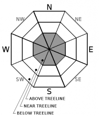
Avalanche Problem 1: Wind Slab
-
Character ?

-
Aspect/Elevation ?
-
Likelihood ?CertainVery LikelyLikelyPossible
 Unlikely
 -
Size ?HistoricVery LargeLargeSmall

Existing wind slabs are shallow, isolated and hard to find. Over the next 24 hours, winds may increase to more favorable speeds for transporting snow and fresh wind slabs may form in leeward terrain above treeline, primarily on the eastern half of the compass (S-SE-E-NE-N aspects). Carefully evaluate leeward slopes 35 degrees and steeper above treeline for the presence of wind slabs.
Wind slabs can be recognized by the appearance of the snow surface, changes in surface snow hardness, hollow, drum-like sounds and/or shooting cracks. Winds that vary in strength and direction can produce complex and unexpected wind slab patterns.
Forecast Discussion
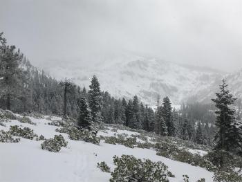
Backcountry conditions are the best they have been all season. Good snow coverage exists above 6,000 ft on Mount Shasta. A total of 162 inches of snow has fallen this season at the Old Ski Bowl weather station (7,600ft) with 75 inches of snow currently on the ground. So far, Mount Shasta City is at 80% of normal for precipitation for the month of March. The Mount Eddy, Ash Creek Butte and Pilgrim Creek Snowmobile Park areas all have good coverage and a useable snowpack. Coverage in the Castle Lake area is still very thin.
Recently, cloudy skies have been protecting snow surfaces from the intense solar radiation that comes this time of year. Just brief periods of sunshine yesterday caused roller balls on steep southerly slopes below treeline. Roller balls and pinwheels will likely occur again today with increasing solar radiation.
Recent Observations
Just over two feet of snow has been added to our snowpack since 03/13. The storm snow is right-side-up and well bonded to itself and the old snow surface. No avalanches or significant signs of instability have been observed recently. Yesterday and overnight, W/NW winds have averaged 10-15 mph with gusts to 21 mph at the Grey Butte weather station. Minor wind loading was observed on S-SE-E aspects above treeline yesterday along Green Butte Ridge, Casaval Ridge and Giddy Giddy Gulch. Small wind lips exist and blowing snow was visible, but wind slabs were hard to find. Plenty of snow is available for transport with about 6-8 inches of ski penetration. Most snow surfaces remained dry and ski quality was good. Roller balls occurred on steep south facing slopes below treeline in response to brief periods of intense solar radiation.
Weather and Current Conditions
Weather Summary
A weak disturbance off the Pacific Northwest coast will continue to send clouds and scattered showers to northern California. Today will be partly sunny with highs in the mid 30s and 10-15 mph winds out of the west. Tonight, winds will increase slightly and shift to the southwest with light snow showers possible above 4,000 ft. Low pressure arrives Tuesday night bringing snowfall through the end of the week.
24 Hour Weather Station Data @ 3:00 AM
| Weather Station | Temp (°F) | Wind (mi/hr) | Snow (in) | Comments | ||||||||
|---|---|---|---|---|---|---|---|---|---|---|---|---|
| Cur | Min | Max | Avg | Avg | Max Gust | Dir | Depth | New | Water Equivalent | Settlement | ||
| Mt. Shasta City (3540 ft) | 30 | 29 | 42 | 33.5 | 0 | N | ||||||
| Sand Flat (6750 ft) | station down | |||||||||||
| Ski Bowl (7600 ft) | 14.5 | 9 | 29.5 | 17.5 | 75.5 | 1 | .02 | 1 | ||||
| Gray Butte (8000 ft) | 14.5 | 11 | 29 | 18.5 | 6 | 21 | WNW | |||||
| Castle Lake (5870 ft) | station down | |||||||||||
| Mount Eddy (6509 ft) | 12 | 11.5 | 26.5 | 19.5 | 1 | 6 | 47.5 | 1 | 3 | |||
| Ash Creek Bowl (7250 ft) | station down | |||||||||||
| Ash Creek Ridge (7895 ft) | station down |
Two Day Mountain Weather Forecast
Produced in partnership with the Medford NWS
| For 7000 ft to 9000 ft | |||
|---|---|---|---|
|
Sunday (4 a.m. to 10 p.m.) |
Sunday Night (10 p.m. to 4 a.m.) |
Monday (4 a.m. to 10 p.m.) |
|
| Weather | Partly sunny | A 30 percent chance of snow showers, mainly before 11pm. Mostly cloudy. | Partly sunny |
| Temperature (°F) | 31 | 21 | 35 |
| Wind (mi/hr) | S 0-5 mi/hr | NW 0-5 mi/hr | S 0-5 mi/hr |
| Precipitation SWE / Snowfall (in) | / 0 | / 0-1 | / 0 |
| For 9000 ft to 11000 ft | |||
| Sunday | Sunday Night | Monday | |
| Weather | Partly sunny and cold, Wind chill values as low as -13. | A 40 percent chance of snow showers, mainly before 11pm. Mostly cloudy. Wind chill values as low as -10. | Partly sunny. Wind chill values as low as -3. |
| Temperature (°F) | 10 | 9 | 17 |
| Wind (mi/hr) | W 15-20 mi/hr | SW 0 | SW 15-20 mi/hr |
| Precipitation SWE / Snowfall (in) | / 0 | / 0-1 | / 0 |
Season Precipitation for Mount Shasta City
| Period | Measured (in) | Normal (in) | Percent of Normal (%) |
|---|---|---|---|
| From Oct 1, 2023 (the wet season) | 14.33 | 33.38 | 43 |
| Month to Date (since Apr 1, 2024) | 3.44 | 3.88 | 89 |
| Year to Date (since Jan 1, 2024) | 8.50 | 18.17 | 47 |

